

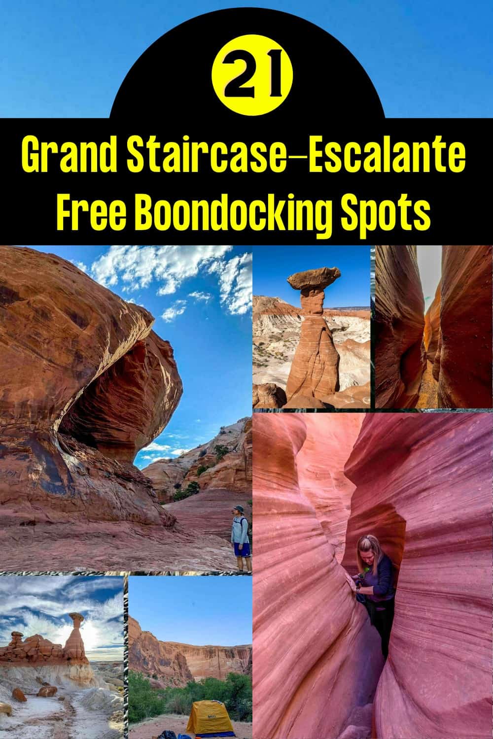
The Grand Staircase-Escalante National Monument is a network of slot canyons with breathtaking rock formations that feel otherworldly and interesting clusters of hoodoos. It is home to awesome archeological finds and geographical formations that are prehistorical and features rock art and cliff dwellings from prehistoric tribes.
Want more ideas to round-out your trip to Utah?
A lot of great ideas are in these posts!
- 24 Amazing Arches National Park Hiking Trails – Easy, Moderate, Hard
- 19 Great NE Utah Boondocking Spots With Maps
- 32 Free North-Central Utah Boondocking Areas Along With Maps
- 24 Top NW Utah Boondocking Locations Including Maps
- 51 Amazing East-Central Utah Boondocking Campsites And Maps
- 33 Best Central Utah Boondocking Sites Also Maps
- 21 Favorite West-Central Utah Boondocking Camp Sites Plus Maps
- 36 Free SE Utah Boondocking Camping Sites And Maps
- 43 Amazing South-Central Utah Boondocking Campgrounds With Maps
- 54 Top SW Utah Boondocking Camping Areas Including Maps
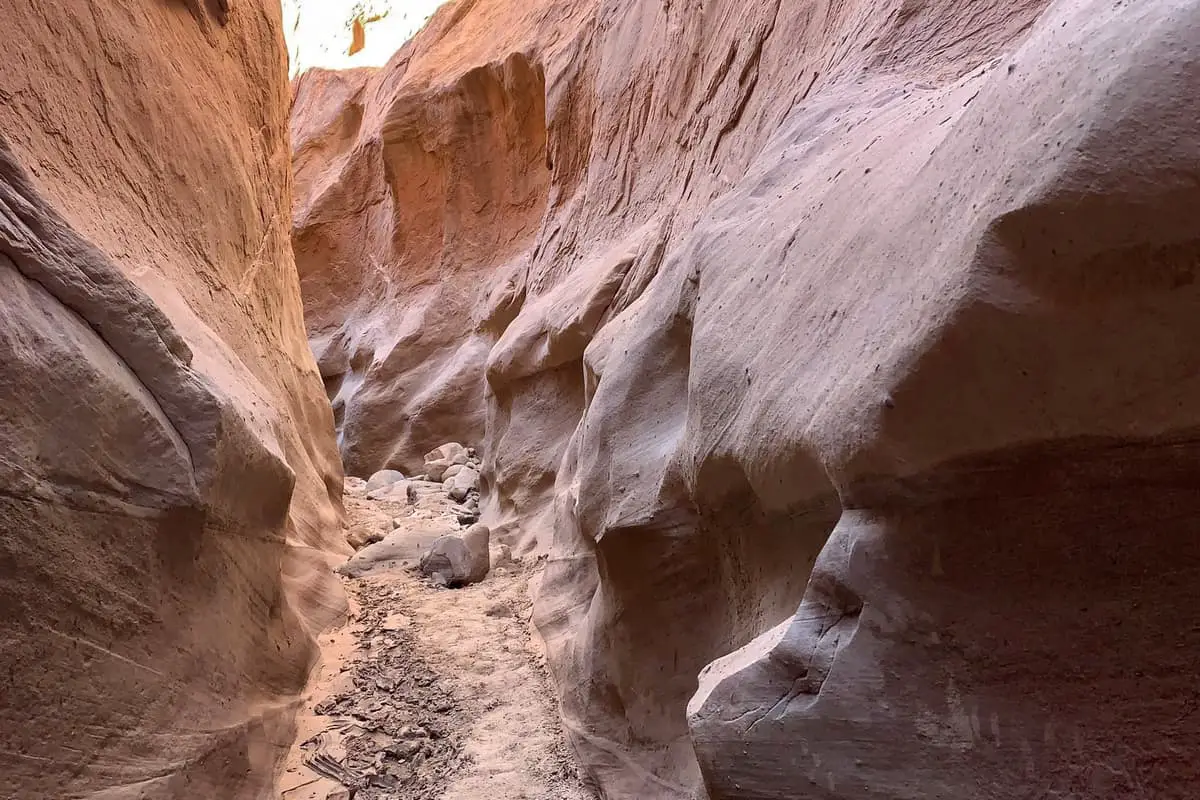
It is an area of Utah in the Gray Cliff region that is not as explored as the White and Pink Cliffs beyond the Grand Staircase-Escalante National Monument, yet has the largest collection of slot canyons. The Grand Staircase-Escalante National Monument features not only diverse rock formations but also offers trails for a variety of skill levels for the whole family.
Stretching from the north rim of the Grand Canyon to the High Plateaus, the Grand Staircase-Escalante National Monument is a series of cliff band in different colors, type of rock, and age. The colorful cliffs get progressively higher as they continue across Utah, and was one of the first national monuments established in 1997 to protect the natural ecosystem.
The slot canyons were formed from erosion and feature striped rock walls throughout as well as waterfalls and pools that create small oasis along the way.
Grand Staircase-Escalante National Monument Information
Grand Staircase-Escalante National Monument covers a vast amount of space, over 1.87 million square acres. Take distance of each boondocking area with a grain of salt since the are measured to the geographic center of the monument.
Going to Grand Staircase means you will surely be visiting other areas such as Bear Ears, Arche National Park, Canyonland and Zion National Parks and more. The America the Beautiful Pass is only $80 a year for the whole family and you can avoid the $35 entrance fee to every National Park in the U.S. You Can Purchase Here.
In addition Utah offers annual passes to its state parks. There are 3 types listed below and You Can Purchase Here.
Annual Day Use Pass – $100
Pass is good only for day use entrance fees at Utah State Parks. Pass cannot be used at the Jordan River OHV Center or at This Is the Place Heritage Park and does not cover the Davis County Causeway fee at Antelope Island State Park. Pass does not provide a discount for camping.
Senior Annual Day Use Pass – $50
Pass is good only for day use entrance fees at Utah State Parks for visitors 65 years of age and over. Pass cannot be used at the Jordan River OHV Center or at This Is the Place Heritage Park and does not cover the Davis County Causeway fee at Antelope Island State Park. Pass does not provide a discount for camping.
Out-of-State Annual Pass – $150
Pass is good only for day use entrance fees at Utah State Parks for visitors that do not reside in the State of Utah. The pass cannot be used at the Jordan River OHV Center or at This Is the Place Heritage Park and does not cover the Davis County Causeway fee at Antelope Island State Park. Pass does not provide a discount for camping.
21 Grand Staircase-Escalante National Monument Boondocking Spots
check out our video
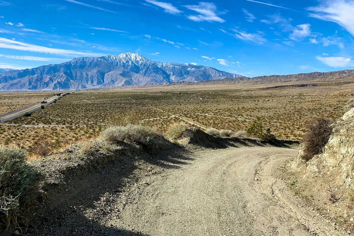
1. Grand Staircase-Escalante National Monument Boondocking Locations – Grand Staircase Dispersed Camping
Click More Details Below for Map
Address
Harris Washington Road
Escalante, Utah
GPS: 37.606059, -111.424887
Elevation: 5413′
Management: National Park Service
The road into this Grand Staircase Escalante Free Campsite is Dirt. Grand Staircase-Escalante National Monument has free dispersed camping throughout the park. This road in is Dirt and 2.5 miles from a paved road. The staircase is open year round. There are 1-5 campsites at this location. You may stay 14 days.
Best Review:
The road in is Dirt. Grand Staircase-Escalante National Monument has free dispersed camping throughout the park. All they ask is that you get a free permit from the visitor center in Escalante and only park in already established pull-outs (don’t just drive off the road anywhere you want). There are many great spots to park for the night and set up a tent or sleep in your car on Hole-In-The-Rock Road, or you can go down one of the side roads. Harris Wash Road has some beautiful spots to camp at, but keep in mind that the side roads are rough and may become unpassable in the rain. Some require high clearance vehicles. I made it all the way down Harris Wash Rd in my Subaru Outback, but conditions could change. Happy Camping!

2. Grand Staircase-Escalante National Monument Boondocking Spots – Harris Wash Campsite
Address
Utah
GPS: 37.63078, -111.347213
Elevation: 5003′
Management: Bureau of Land Management
The road into this Grand Staircase Escalante Free Campsite is Dirt. Harris Wash Campsite is open year round. There are 1-5 campsites at this location. You may stay 20-25 days at Harris Wash Campsite. The Harris Wash road is located 10.4 miles from Highway 12 (1.4 miles south of Reference Marker 15) on the east side of Hole-in-the-Rock Road, and is clearly marked with a BLM sign.
Best Review:
None
3. Grand Staircase-Escalante National Monument Boondocking Locations – Tin Can Flat
Address
2.5 miles from Highway 12
Utah
GPS: 37.696603, -111.508203
Elevation: 5548′
Management: Bureau of Land Management
The road in is Dirt and 2.5 miles from a paved road. Tin Can Flat is open year round. There are 1-5 campsites at this location. You may stay 20-25 days at Tin Can Flat.
Best Review:
Pretty nice , there were somebody on the first spot on the flat area, we got the next one, on the hill. Nice view, rock campfire.
4. Grand Staircase-Escalante National Monument Boondocking Spots – Grand Staircase Escalante NM – Tin Can Flat Dispersed
Address
Hole in the Rock Road
Escalante, Utah
GPS: 37.72025627, -111.5205861
Elevation: 5663′
Management: Bureau of Land Management
Tin can flats is a wide open field with a few trees scattered about. No services. Take it out with you!!! Good spot to boondock, but lots of dust from the road if the wind is blowing west.
The road in is Gravel and 0.2 miles from a paved road. Overnight permits are required within the Monument for all overnight car camping or backpacking. Permits are free of charge and may be obtained at any of our visitor centers or at developed trailheads.
Best Review:
5. Grand Staircase-Escalante National Monument Boondocking Locations – HWY12/Hole in the Rock Road
Address
Escalante, Utah
GPS: 37.723522, -111.527199
Elevation: 5715′
Management: Bureau of Land Management
The road into this Grand Staircase Escalante Free Campsite is Gravel and 0.2 miles from a paved road. Overnight permits are required within the Monument for all overnight car camping or backpacking. Permits are free of charge and may be obtained at any of our visitor centers or at developed trailheads.
Best Review:
We camped here for a week back in May and had a really nice time. It was pretty busy here but the area is just a big open meadow with some roads criss-crossing it. We pulled in on a Sunday and it was crowded but we found a nice place in the middle to tuck between two large junipers and find some ‘privacy in plain site’. Then on Monday when some weekenders cleared out we grabbed a spot on the edge of the meadow that was very quiet and private except for our extremely kind neighbor, who was a retired photographer living out his dream in a tent.
6. Grand Staircase-Escalante National Monument Boondocking Spots – Old Sheffield Road
Address
Escalante, Utah
GPS: 37.722897, -111.437623
Elevation: 6020′
Management: Bureau of Land Management
Old Sheffield Road is open year round. You may stay 20-25 days at Old Sheffield Road. Easy access down all gravel road. I seen several marked sites along the road, and some unmarked. Made it back in a Ford sedan, no problem.
Best Review:
Easy access down all gravel road. I saw several marked sites along the road, and some unmarked. Made it back in a FWD sedan, no problem.
7. Grand Staircase-Escalante National Monument Boondocking Locations – Spencer Flat
Address
Spencer Flat Road
Escalante, Utah
GPS: 37.726656, -111.443787
Elevation: 5935′
Management: Bureau of Land Management
Free Dispersed camping in the Bureau of Land Management N/A District. Reservations are not accepted at this campsite. Great views. There are quite a few spots on this road. I
Best Review:
All the easy ones were full so I had to drive several miles back, across a flat space. Going up the hill on the other side, I needed to engage my 4WD so if you don’t have that, take one of the earlier sites if you can. But I woke to fabulous views of the valley.
8. Grand Staircase-Escalante National Monument Boondocking Spots – Escalante Monument Area
Address
Escalante, Utah
GPS: 37.747888, -111.458359
Elevation: 6309′
Management – Public – Bureau of Land Management
The road into this Grand Staircase Escalante Free Campsite is Dirt. All campsites in the area are open year round. There are 1-5 campsites at this location. You may stay 14 days at any site in the Grand Staircase.
Best Review:
Beautiful right off Hwy 12. There is a relay tower on top of the hill and camp spots for at least a half dozen campers with plenty of privacy. I was there for about a week and had no problems.
9. Grand Staircase-Escalante National Monument Boondocking Locations – Dixie National Forest
Address
Utah
GPS: 37.682508, -111.833474
Management: National Forest Service
There are 1-5 campsites at this location. You may stay 14 days at Dixie National Forest.
Best Review:
We looked for a place and turned off north on 148 in the Dixie National Forest. There was a sign that said not to drive off the road except in the designated areas. We drove a couple miles down the road and found a site with a nice built up fire ring and stopped there.
I don’t know if there were sites further down the road as we didn’t explore further but the one we stayed at was gorgeous… wildflowers everywhere, a view of Escalante National Monument through the trees. I would guess a smaller RV would fit there and the gravel road was a smooth drive.
10. Grand Staircase-Escalante National Monument Boondocking Spots – Smoky Mountain
Address
Utah
GPS: 37.1879, -111.4515
Elevation: 5656′
Management: Bureau of Land Management
The road into this Grand Staircase Escalante Free Campsite is Dirt. All campsites in the area are open year round. There are 1-5 campsites at this location. You may stay 14 days at any site in the Grand Staircase.
Best Review:
Unbelievable cliff views overlooking Utah, Arizona and Lake Powell. You’ll need a pretty capable SUV or 4×4 to get to this site…and you cannot access it during or after a rain.
Beautiful overlook with amazing sun set and rise. The Stars were vibrant all night. Bring firewood, what’s up there from the brush is sporadic. A little windy but nothing dangerous. The drive up was dry in May. The last leg was steep with a big drop off on one side. One way up with few turnarounds. Big rigs not recommended, 4×4 is recommended going up and better suited in case the weather gets soggy.
11. Grand Staircase-Escalante National Monument Boondocking Locations – Henrieville Creek
Address
Henrieville, Utah
GPS: 37.616936, -111.896866
Elevation: 6656′
Management: Bureau of Land Management
The road in is Gravel and .01 miles from a paved road. Henrieville Creek – Escalante NM Grand Staircase is open all year. There are 1-5 campsites at this location and the maximum RV length is 25′. You may stay 14 days at Henrieville Creek – Escalante NM Grand Staircase.
Best Review:
I visited in September last year in a 36ft motorhome. It’s pretty low to the ground but I did not drag bottom. I enjoyed it very much and it is a great place to stay to visit Kodachrome, SP.
12. Grand Staircase-Escalante National Monument Boondocking Spots – Cottonwood Canyon Road
Address
Henrieville, Utah
GPS: 37.480583, -111.922343
Elevation: 6112′
Management: Bureau of Land Management
The road into this Grand Staircase Escalante Free Campsite and 46 miles from a paved road. There are 16-29 campsites at this location.
Best Review:
Free dispersed camping along Cottonwood Canyon Road between Big Water and Kodachrome State Park located inside BLM land under Grand Staircase-Escalante National Monument. No fires unless in stove/pan. Many possible sites right off of main road. Main road is unpaved and very rough at times and definitely impassable when wet.
13. Grand Staircase-Escalante National Monument Boondocking Locations – Pump Canyon Springs
Address
Cottonwood Canyon Road
Kanab, Utah
GPS: 37.3431, -111.8706
Elevation: 5236′
Management: Bureau of Land Management
The road in is Dirt. All campsites in the area are open year round. There are 1-5 campsites at this location. You may stay 14 days at any site in the Grand Staircase.
Best Review:
This is a nice, private site with summer shade off of Cottonwood Canyon Road. There are many other sites, some needing high clearance to get to, this one you can get to with out. There is one site here, but it’s off a large loop where you could fit more vehicles. Great views and close to Lower Hackberry & Yellow Rock trailheads.
14. Grand Staircase-Escalante National Monument Boondocking Spots – Burr Trail Road
Address
Boulder, Utah
GPS: 37.848545, -111.370552
Elevation: 5839′
Management: Bureau of Land Management
The road into this Grand Staircase Escalante Free Campsite is Paved. There are 1-5 campsites at this location and the maximum RV length is 40+. It’s a pretty spot with a few large trees and views of the sand stone formations. There’s enough room for four or five RVs of any size with lots of spaces leftover. A permit for camping, which can be obtained at any Grand Staircase-Escalante
Best Review:
We camped here last week and at the back of the gravel lot, there was a perfect campsite for us! We camped with our 15’ travel trailer. Star gazing was unbelievable. Trail down the stunning wash started at our site. Views and sunset unbelievable. We couldn’t believe others were parked/camped in the lot and left the campsite for us! Little town of Boulder about 10 min. Away. We ATVd right from campsite and headed south on Burr Trail to a fun area. Not many campsites further down Burr Trail, but the drive is stunning steep red walls down to Burr Switchbacks
15. Grand Staircase-Escalante National Monument Boondocking Locations – Calf Creek Overflow
Address
Boulder, Utah
GPS: 37.87515, -111.44858
Elevation: 6654′
Management: Bureau of Land Management
Nice, and Quite. Stayed 3 Nights, BLM Land. Sign said not over 25 Ft, my rig was 27 ft got in with no problems. Pit toilet, no water or Electric.
Best Review:
Nice, and Quite…. Stayed 3 Nights, Mid Nov 2013, $8 with Senior Pass BLM Land
Sign said not over 25 Ft, my rig was 27 ft got in with no problems
Pit toilet, no water or Electric
16. Grand Staircase-Escalante National Monument Boondocking Spots – Rock Springs Bench Campsite
Address
Cannonville, Utah
GPS: 37.496975, -111.97821
Elevation: 5793′
Management: Bureau of Land Management
The road in is Dirt and 1 miles from a paved road. Rock Springs Bench Campsite- Grand Staircase Escalante NM is open all year. There are 1-5 campsites at this location. You may stay 14 at Rock Springs Bench Campsite- Grand Staircase Escalante NM.
Best Review:
This is an official dispersed camping area in the Escalate National Monument, managed by the BLM.
Kodachrome was full so we camped down here. Passed the first obvious site on the left since it was very exposed but there are a couple nice spots on either side of the road about a hundred yards further. We camped at the left which has great sunrise views, but the site on the right has better sunset views and was taken. It was a little windy but using the junipers as anchors and windscreens worked pretty well. I’m sure the road would be a nightmare when wet but it was dry for us.
17. Grand Staircase-Escalante National Monument Boondocking Locations – Cliffside Off Burr Trail Road
Address
Burr Trail Road
Boulder, Utah
GPS: 37.859209, -111.317048
Elevation: 5955′
Management: Bureau of Land Management
The road in is Dirt. About 4 miles down the road (East) of Deer Creek Campground on Burr Trail Road. A dirt road pull off to the left, before the descent into Long Canyon.
Best Review:
Free, primitive, dispersed camping on the cliff looking out over Long Canyon. Site was recommended to me by the rangers in the Boulder Information center (along with others, tons of BLM land out there). Beautiful view, secluded camping.
18. Grand Staircase-Escalante National Monument Boondocking Spots – North New Home Bench
Address
Forest Road 1431
Boulder, Utah
GPS: 37.890785, -111.461945
Elevation: 6814′
Management: National Forest Service
Free dispersed campsite near highway 12, just outside of Boulder, Utah in the Dixie National Forest. This would probably work best as an overnight stop. It is just west of the junction of Hell’s Backbone/Salt Gulch/State Road 12 and Forest Road 1431 and east of the airport/strip.
Best Review:
There are multiple spots the length of hells back bone road (which is paved). It is quiet, there are no amenities, and it’s free.
19. Grand Staircase-Escalante National Monument Boondocking Locations -Hell’s Backbone Road 1
Address
Boulder, Utah
GPS: 37.894285, -111.470232
Elevation: 6870′
Management: National Forest Service
The road in is Dirt. All campsires in the area are open year round. There are 1-5 campsites at this location. You may stay 14 days at any site in the Grand Staircase.
Best Review:
An easily accessible area with lots of different sites suitable for all sized vehicles. Some sites are smaller and a little harder to get to because of the windy road, but some sites are very easy, and most all of them are very flat. Good views of the slickrock wilderness of Calf Creek and that part of Grand Staircase/Escalante National Monument, but this area is just outside the park. No water, tables, or any other amenities, but free, easy access, nice views, and quiet.
20. Grand Staircase-Escalante National Monument Boondocking Spots – Hells Backbone Road 2
Address
Boulder, Utah
GPS: 37.900584, -111.481361
Elevation: 6776′
Management: National Forest Service
The road in is Dirt. There are 6-15 campsites at this location. Spent the night in this general vicinity while visiting Lower Calf Creek Falls. Multiple places to pull in off the road for tent camping, truck camping and maybe a pop-up. Just a free place to spend the night in the cedars.
Best Review:
None
21. Grand Staircase-Escalante National Monument Boondocking – Sooner Rocks Campsite
Address
Utah
GPS: 37.329007, -111.059914
Elevation: 4278′
Management: Bureau of Land Management
The road in is Dirt. All campsites in the area are open year round. There are 1-5 campsites at this location. You may stay 14 days at any site in the Grand Staircase.
Best Review:
Two separate sites are located 40.1 miles from Highway 12 (just past Reference Marker 65) on the right (west) side of Hole-in-the-Rock Road. The first side road in the canyon leads to an open area in a draw with a backdrop of red rock, visible from the Hole-in-the-Rock road. A second side road, one hundred yards further south on Hole-in-the-Rock road and across from the BLM sign identifying “Sooner Wash” leads up a short rise, and drops down to the right into a bowl-shaped open area less visible from the road.
Top 10 Hiking Trails in Grand Staircase-Escalante National Monument
At over 1 million acres, Grand Staircase-Escalante National Monument is one of the largest national monuments in the United States. The majority of the land within the monument is wild, rugged, and much of it is inaccessible except on foot. Ancient cultures inhabited for thousands of years, and extensive ruins and evidence of these thriving civilizations can be found throughout the area.
When planning a hike through the slot canyons in the Grand Staircase-Escalante National Monument, pack plenty of food, water, sunscreen, and bug spray.
1. Dry Fork Slot Trail
Dry Fork Narrows and Brimstone Slot Canyons is a 8 mile lightly trafficked out and back trail located near Escalante, Utah that offers the chance to see wildlife and is rated as moderate. The trail is primarily used for hiking.
Dry Fork Slot Trail in the is a difficult hike starting at the marked trailhead that is a short walk from either parking area. Make the loop to see the Dry Fork Narrows, Peekaboo, and Spooky slot canyons and prepare for challenging climbs that require rope and help from others in your group. Peekaboo canyon has a hard descent with knee deep water and there are some extremely narrow spots in the slot canyons. The canyons seem endless and there are many difficult ones off the designated path for experienced rock climbers. Start early to avoid ascending during the hottest part of the day and camping is allowed with overnight permits available free at the visitor centers.
Length: 8.0 mi
Elevation gain: 616 ft
Route type: Out & back
Hiking, Views, Wildlife, Rocky, Off trail, No shade
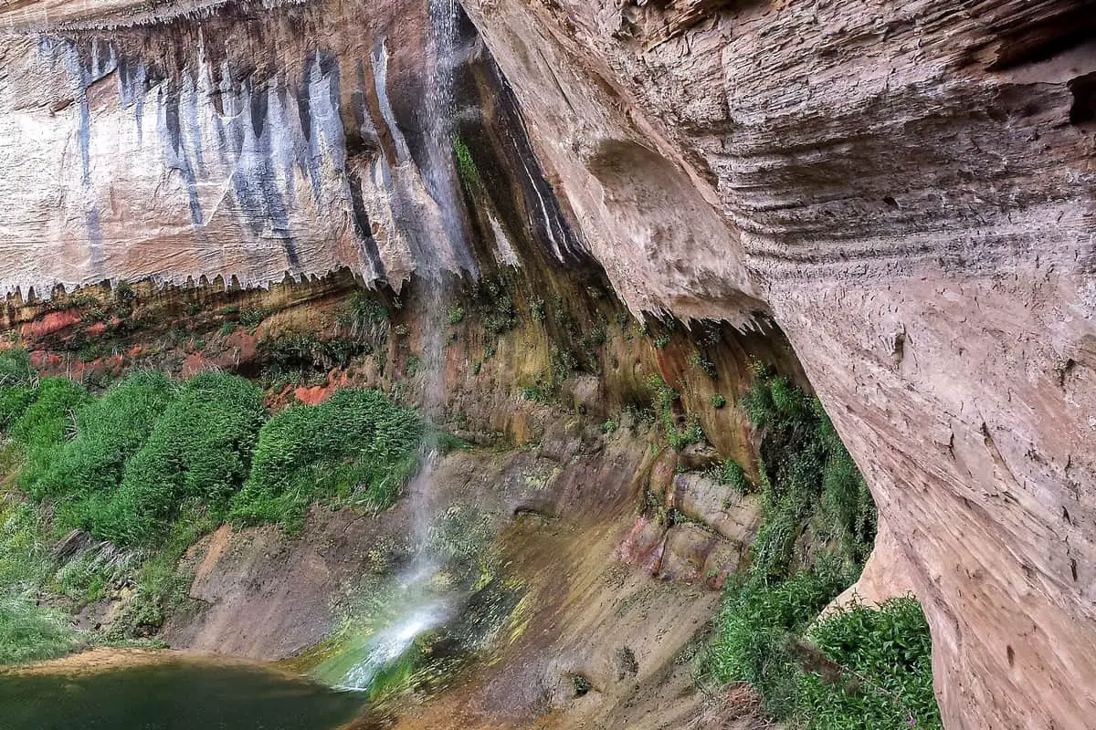
2. Upper Calf Creek Falls Trail
Upper Calf Creek Falls Trail is a 2.1 mile heavily trafficked out and back trail located near Boulder, Utah that features a waterfall and is rated as moderate. The trail is primarily used for hiking, walking, and nature trips and is best used from March until November. Dogs are also able to use this trail.
The Upper Calf Creek Falls trail is a moderate hike starting on slickrock before turning to soil. It is an easy downhill walk to the waterfall with a variety of geological formations, vegetation, and wildlife along the way. The waterfall feeds a nice swimming hole in an oasis environment with thick plants around the swimming hole. It is a nice place to stop, cool off, and eat in shady spots before the difficult uphill climb back. The lower falls are more impressive with better swimming holes; however, the hike further down is even more difficult.
Length: 2.1 mi
Elevation gain: 606 ft
Route type: Out & back
Hiking, Nature trips, Walking, Dog friendly, River, Waterfall, Wildflowers, No shade
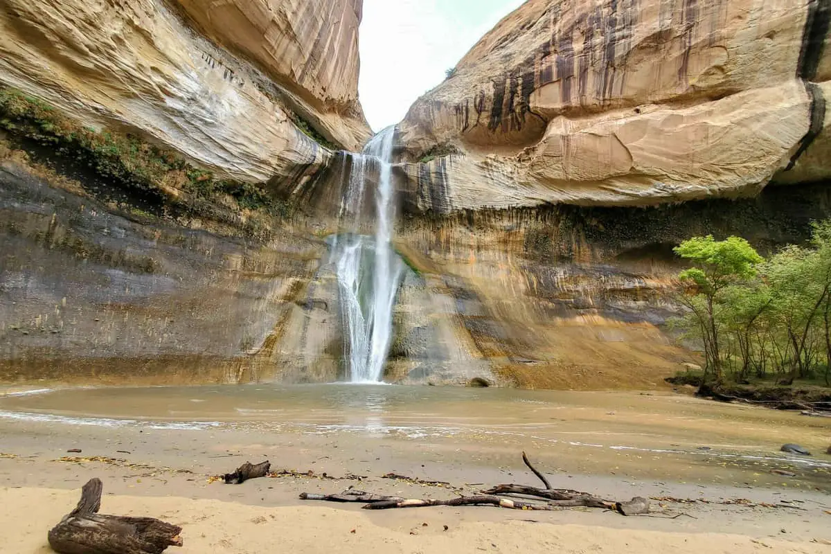
3. Lower Calf Creek Falls Trail
Lower Calf Creek Falls is a 6.7 mile heavily trafficked out and back trail located near Boulder, Utah that features a waterfall and is rated as moderate. The trail is primarily used for hiking, walking, and running and is accessible year-round. Dogs are also able to use this trail but must be kept on leash.
Lower Calf Creek Falls trail in the is a moderate hike that leads to a waterfall. An awesome hike with ponds, marshy areas, and wetlands with ecosystems offering a variety of plant and wildlife along the way. You come across pre-historic rock art and storage granaries on the cliffs used to store food, seeds, and other supplies above any flood water. Enjoy the colorful walls of the canyon that has dark lines known as desert varnish that results from windblown rail and wind causes erosion.
Length: 6.7 mi
Elevation gain: 866 ft
Route type: Out & back
Dogs on leash, Kid friendly, Hiking, Walking, Running, River, Views, Waterfall, Wildflowers, Wildlife, No shade, Fee
4. Toadstool Hoodoo Trail
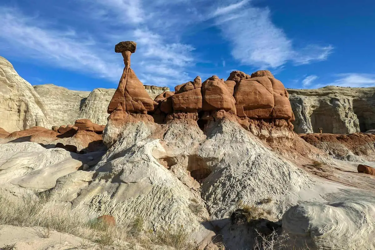
Toadstool Hoodoos Trail is a 1.8 mile heavily trafficked out and back trail located near Kanab, Utah that offers scenic views and is good for all skill levels. The trail offers a number of activity options and is accessible year-round. Dogs are also able to use this trail but must be kept on leash.
Toadstool Hoodoo trail is an easy hike that is perfect for the whole family and dogs with a few small inclines on a sandy path. The trail leads to the Toadstool hoodoo which has a white stem and red cap which is a large boulder sitting on pedestal rock that looks similar to a mushroom. Hoodoos were formed when boulders fall onto softer rocks that create a column underneath caused by protection from erosion. Continue on the trail to the left to see more hoodoos including on cliffs and impressive views of diverse landscapes and rock formations in a short hike.
Length: 1.8 mi
Elevation gain: 141 ft
Route type: Out & back
Dogs on leash, Kid friendly, Hiking, Nature trips, Walking, Bird watching, Running, Views, Rocky, No shade
5. Willis Creek Narrows Trail
Willis Creek Narrows Trail is a 5.8 mile heavily trafficked out and back trail located near Cannonville, Utah that features a waterfall and is good for all skill levels. The trail offers a number of activity options and is best used from April until November. Dogs and horses are also able to use this trail.
Willis Creek Narrows trail is an easy hike for any skill level. Horses are allowed and occasional cattle is seen cooling off in the narrows which is perfect on hot sunny afternoons hiking the creek bed through high stone walls bathed in shadows. Around 20 minutes into the hike is a small waterfall as you go through some slot canyons before following the creek bed to the Sheep Creek Wash. The road to the trail requires vehicle with good ground clearance and there are undeveloped campsites with views of the Pink Cliffs along the road.
Length: 5.8 mi
Elevation gain: 1,227 ft
Route type: Out & back
Kid friendly, Hiking, Horseback riding, Nature trips, Walking, Bird watching, Dog friendly, River, Views, Waterfall, Wildflowers, Wildlife, Rocky, Historic site
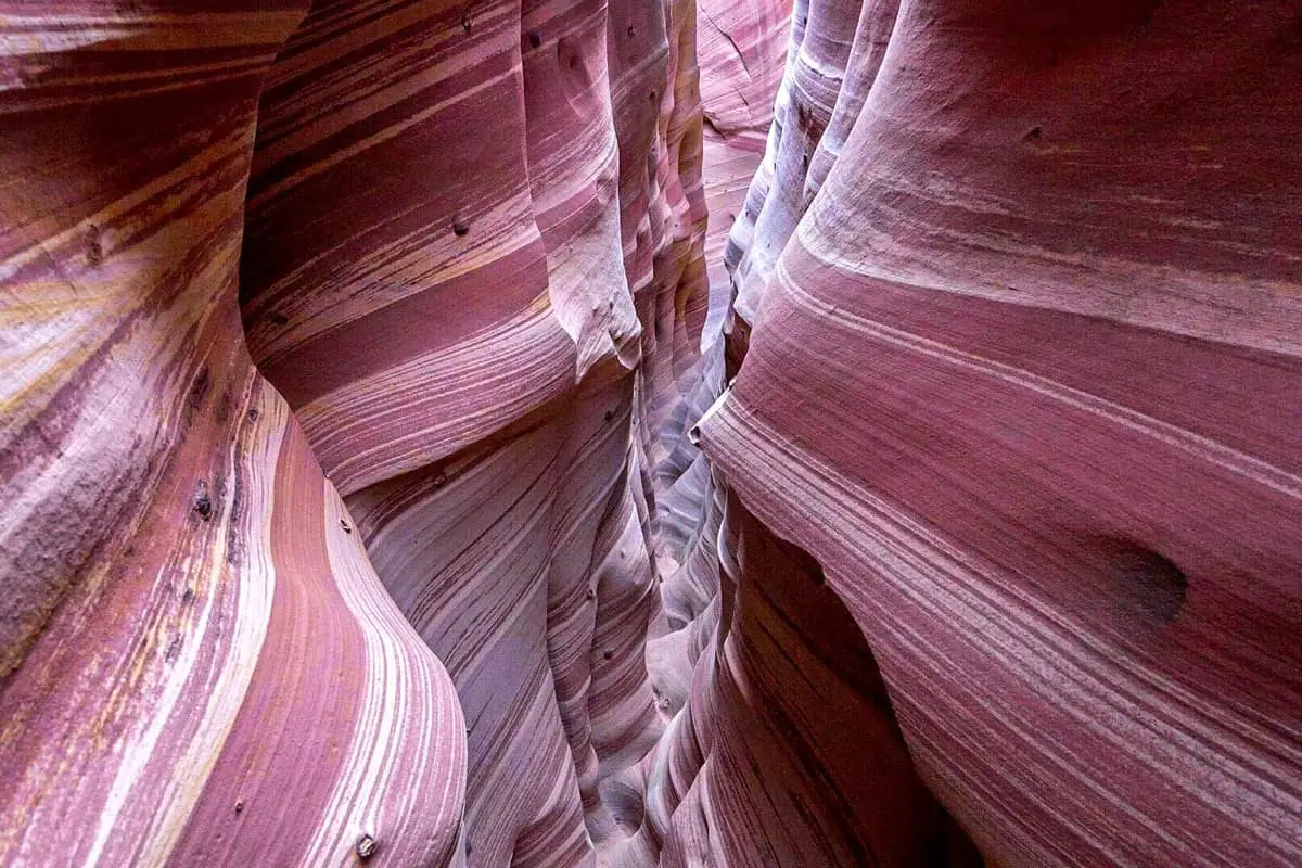
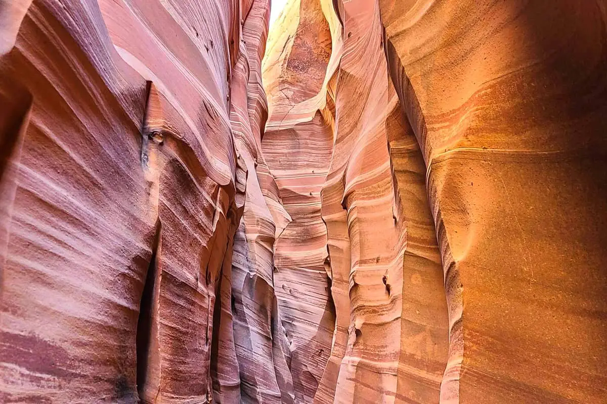
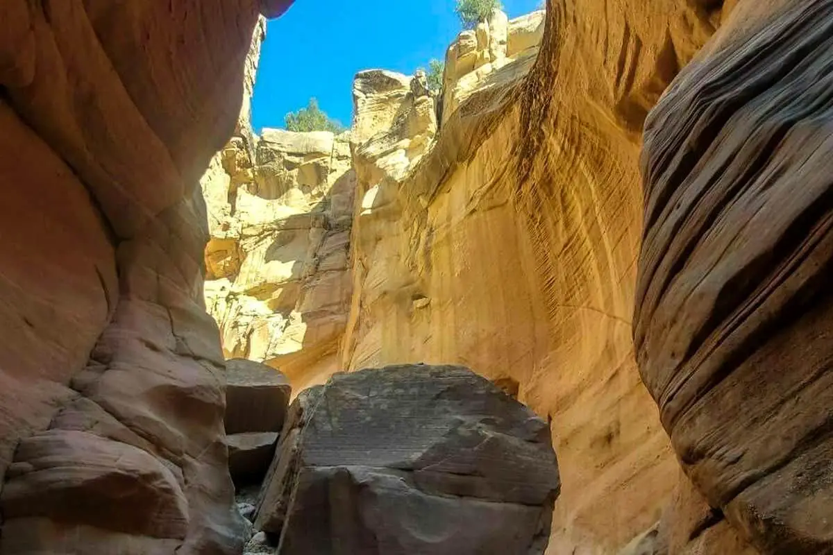
6. Zebra Canyon Trail
Zebra Canyon is a 5.2 mile heavily trafficked out and back trail located near Escalante, Utah that offers scenic views and is rated as moderate. The trail is primarily used for hiking, walking, and nature trips and is best used from April until November. Dogs are also able to use this trail but must be kept on leash.
Zebra Canyon trail is a moderate hike in the full sun to the canyon. Depending on whether it rained recently, the canyon can be full of water and the stream crossing are full as well. The trail goes slightly downhill as it approaches the Harris Wash, and go through the gate into a wide canyon and turn left to follow the west bank as far as possible. Do not follow others steps off the trail and miss the entrance to Zebra Canyon by not immediately crossing the wash. The hike gets more difficult once in Zebra Canyon as it gets fairly tight in the slot canyon and once over the boulder into the deeper parts you see the amazing striped walls. Once through Zebra Canyon, there is an opportunity to take a loop to the Tunnels slots in the opposite direction.
Length: 5.2 mi
Elevation gain: 377 ft
Route type: Out & back
Dogs on leash, Hiking, Nature trips, Walking, Views
7. Zebra and Tunnel Canyons Trail
Zebra and Tunnel Slots is a 6.6 mile heavily trafficked loop trail located near Escalante, Utah that offers the chance to see wildlife and is rated as moderate. The trail is primarily used for hiking, walking, and nature trips and is best used from March until November. Dogs are also able to use this trail but must be kept on leash.
The Zebra and Tunnel Canyons is mostly moderate hiking to the Zebra Canyon and includes the loop trail to the Tunnel Canyon. The walk to the Tunnel Canyon on the sandstone had nice panoramic views along the top of the canyons. Go through a gate and follow another fence down to the Tunnel Canyon for an easy 200 feet walk when it is dry. Zebra Canyon is more challenging for some people; however, the Tunnel Canyon is a wide wash and good for all skill levels.
Length: 6.6 mi
Elevation gain: 442 ft
Route type: Loop
Dogs on leash, Hiking, Nature trips, Walking, Views, Wildlife, Rocky, No shade, Dogs on leash
8. Devil’s Garden Trail
Devils Garden Trail is a 4.1 mile lightly trafficked out and back trail located near Whitewater, California that features beautiful wild flowers and is rated as moderate. The trail is primarily used for hiking, walking, nature trips, and bird watching and is accessible year-round.
Devil’s Garden trail is an easy hike on a loop trail filled with hoodoos, arches, and stone structures. It is a perfect area to visit when you are hiking trails in the area because it is short with grills and picnic tables available. Make lunch and let kids explore the area or end the day there to see the sunset and camp nearby. Wander around to see the awesome Metate Arch, Mano Arch, and Four Hoodoos with beautiful colors and stunning formations. A short fun walk for the whole family to explore the giant hoodoos.
Length: 4.1 mi
Elevation gain: 1,243 ft
Route type: Out & back
Hiking, Nature trips, Walking, Bird watching, Views, Wildflowers, Wildlife, Bugs, No dogs
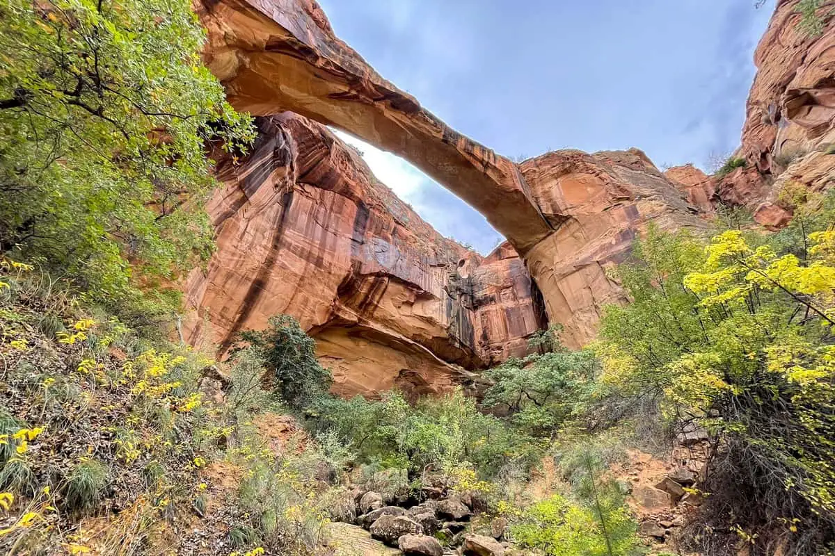
9. Escalante Natural Bridge Trail
Escalante Natural Bridge is a 4.4 mile moderately trafficked out and back trail located near Escalante, Utah that features a river and is good for all skill levels. The trail is primarily used for hiking and is best used from April until November. Dogs are also able to use this trail but must be kept on leash.
Escalante Natural Bridge is an easy hike that crosses a river several times. Take the south side of the canyon to get to the natural bridge after an easy walk in Cottonwood groves. The petroglyphs are to the left of the Pablo ruins up on the rock shelf with plenty of shade and water for dogs or kids to cool off. The trail is not well marked so stay close to the river to avoid getting lost. Continue after the first bridge to see the cliff dwellings and second bridge. Watch for sandspurs getting in dogs; paws and areas of thick brush are tricky, but otherwise a nice easy hike with amazing views. At the southeast corner of the concrete bridge by the trailhead, a storage granary is visible beneath the rock formation Kiva Koffeehouse sits on.
Length: 4.4 mi
Elevation gain: 291 ft
Route type: Out & back
Dogs on leash, Kid friendly, Hiking, River, Views, No shade, Historic site
10. Bull Valley Gorge Trail
Bull Valley Gorge Trail is a 0.9 mile lightly trafficked out and back trail located near Cannonville, Utah that features a river and is rated as difficult. The trail is primarily used for hiking, walking, and rock climbing and is best used from May until October.
Bull Valley Gorge Trail is a difficult hike of almost a mile with an easy walk to the canyon, but is difficult to climb down and ropes may be needed to get to the bottom of the gorge. Hike through narrow passages for most of the path and climb over rocks until reaching a spot with a log to climb over a boulder where you can pass by going under. Just beyond that is the bridge by the parking area, but the canyon goes on further. There is a crushed truck from an accident in the 1950’s about 600 feet from the bottom of the gorge that fell off the one-way bridge when it stalled. The bridge on Skutumpah Road has since been rebuilt and is sturdier but the truck could not be moved.
Length: 0.9 mi
Elevation gain: 75 ft
Route type: Out & back
Hiking, Rock climbing, Walking, River, Views, Rocky, Scramble, No dogs
Activities at the Grand Staircase-Escalante National Monument
There are a variety of activities at the Grand Staircase-Escalante National Monument such as hiking, horseback riding, camping, or fishing through the various trails and slot canyons. Take the proper supplies for desert conditions, swimming, and bug spray for hikes. Check out national parks nearby, Kiva Koffeehouse near the natural bridge trail, or museums in towns, or stargaze at a Dark Park for a variety of things to do while visiting the Grand Staircase-Escalante National Monument. Get an overnight pass for camping and backpacking through different trails, or hike some of the shorter, easier trails with family. The national parks around the Grand Staircase-Escalante National Monument are great places to visit to see more of the area.
You May Want to Join Our Boondocking Group on Facebook For More Information
You May Want to Join Our Campfire Recipes Group on Facebook For More Information