

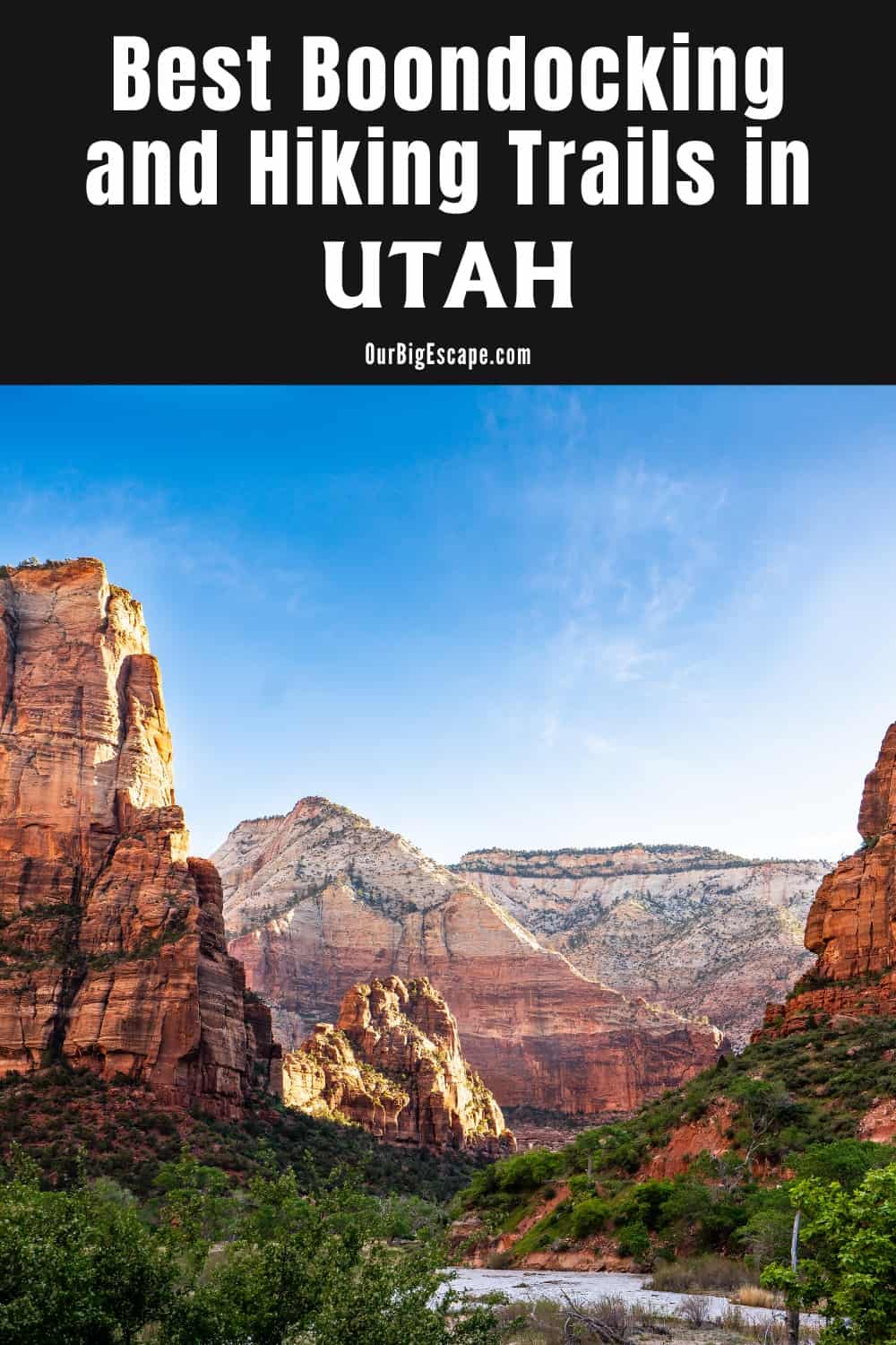
Free camping at Utah boondocking areas, hiking in Utah through spectacularly colored sandstone slot canyons, climbing nearly 12,000-foot peaks, or rafting down the mighty Colorado River are all possibilities. All of this is feasible in Utah, where adventure is at its core. Furthermore, these activities are only a few hours away from one another.
| These Boondocking & Camping Areas are concentrated in the North-Central part of Utah |
Camping in Utah Boondocking Areas
Camping is available for free near Park City and the Wasatch Range. Utah may boast of having “the greatest snow on earth,” but that snow wouldn’t be nearly as beneficial if it weren’t for the breathtaking mountains it is stuck on. Skiers in the winter and adventure-seeking campers in the summer appreciate these mountains.
Beautiful boondocking and tent camping on national forest areas can be found near Salamander Flat and Heber Mountain. Another option near the Wasatch is BLM dispersed camping along Mud Creek Road near Strawberry Reservoir.
32 Free North-Central Utah Boondocking Areas
1. Nebo Loop Rd
Address
Forest Road 164
Nephi, Utah
GPS: 39.732445, -111.7595
Elevation: 6040′
Management: Public – Forest Service
Free Utah boondocking areas in the Uinta-Wasatch-Cache National Forest’s Spanish Fork Ranger District. First come -> first camped. No reservations are accepted.
2. Nebo Loop
Address
Nephi, Utah
GPS: 39.762022, -111.711299
Elevation: 6194′
Management: Public – Bureau of Land Management: (Unofficial)
Utah boondocking campgrounds where there is a toilet and plenty of parking and camping space. Lots to explore around here. If you are tent camping head up the mountain on the road and there are some more secluded primitive spots, just pull off and unload
3. Cottonwood Campground
Address
Nephi, Utah
GPS: 39.781601, -111.723831
Elevation: 6544′
Management: Public – Forest Service (USDA)
Gravel Roads and Spurs, River or Stream, Cottonwood and Maples, Timbered Setting. Utah boondocking areas facilities not modified.
4. Nebo Creek FS
Address
Fairview, Utah
GPS: 39.869455, -111.592335
Elevation: 5965′
Management: Public – Forest Service (Unofficial)
The road in is Gravel and 3.5 miles from a paved road. Nebo Creek FS is open May 1 – Nov 1. There are 1-5 Utah boondocking campgrounds at this location and the maximum RV length is 25 feet. You may stay 14 days at Nebo Creek FS.
5. Bryces Draw
Address
Elk Ridge, Utah
GPS: 39.90039, -111.726
Elevation: 7139′
Management: Public – Forest Service (Official)
Utah boondocking areas approx 1 mile above tinneys flat…santaquin canyon Utah take main st and center street go south up santaquin canyon you will go through trombolt, which has a lot of free sites and sites for tents etc.
6. Jackson Dispersed
Address
Forest Road 149
Utah
GPS: 40.014092, -110.960582
Elevation: 8442′
Management: Public – Forest Service
Free Utah boondocking campgrounds in the Ashley National Forest’s Duchesne Ranger District. First come -> first camped. No reservations are accepted. This is a high elevation location.
7. Sheep Creek Camping Area
Address
Spanish Fork, Utah
GPS: 39.983693, -111.332425
Elevation: 5935′
Management: Public – Forest Service (Official)
The road in is Gravel. There are 16-29 Utah boondocking areas at this location and the maximum RV length is unlimited. You may stay 14 days at Sheep Creek Camping Area. Large open level dispersed camping area. Easy access for larger rigs from highway 6. No amenities other than rock fire rings. Very little shade.
8. Lake Fork
Address
Fairview, Utah
GPS: 39.93871, -111.41755
Elevation: 5994′
Management: Public – Forest Service
The road in is Dirt and Depends on the campsite you choose. miles from a paved road. There are 6-15 Utah boondocking campgrounds at this location and the maximum RV length is 25 feet. You may stay 16 Days at Lake Fork. Lake fork is beautiful! I’ve been going here every summer for the past 25 years. The fires in 2018 took quite a bit out but its still a wonderful place to get away!
9. Hobble Creek Dispersed Camping
Address
Right Fork Hobble Rd
Springville, Utah
GPS: 40.20068, -111.417231
Elevation: 5758′
Management: Public – Forest Service
The road in is Dirt and 1 mile miles from a paved road. You may stay 14 days in Utah boondocking areas at Hobble Creek Dispersed Camping. At about 10 to 12 miles up canyon. Keep to the right. Road will get smaller. Go until you get past the paved road. Go another mile and camp anywhere.
10. Sawmill Hollow
Address
Forest Road 386
Springville, Utah
GPS: 40.141154, -111.340659
Elevation: 6194′
Management: Public – Forest Service (Official)
The road in is Paved. There are 6-15 Utah boondocking campgrounds at this location and the maximum RV length is 35 feet. You may stay 14 days at Sawmill Hollow. This campsite is located within the Uinta-Wasatch-Cache National Forest’s Spanish Fork Ranger District. Small free campground right inside the dispersed camping area. Shirt drive to hot spring trail head. Pit toilet, fire rings, picnic tables. Near the stream. Suitable for rigs under 30ft. and tent campers. We stayed at a nearby dispersed site, but wanted to post this for those need the toilets etc.
11. Diamond Fork Dispersed Camping
Address
Springville, Utah
GPS: 40.112287, -111.337165
Elevation: 6122′
Management: Public – Forest Service (Unofficial)
Utah boondocking areas in Diamond Fork Dispersed Camping is open spring through fall. On the first 12 miles of Diamond Fork Rd, camping is only allowed in designated sites, but past that point there are a lot of distributed camping area between the waterside and the road.
12. Clyde Creek
Address
1.1 mi on Strawberry Rd
Heber, Utah
GPS: 40.228302, -111.191681
Elevation: 7672′
Management: Public – Forest Service (USDA) (Unofficial)
The road in is Gravel and 0-5 miles from a paved road. Clyde Creek is open Summer, Fall. There are 30 or more Utah boondocking campgrounds at this location. You may stay 14 at Clyde Creek.
13. Mud Creek
Address
2.9 mile, Strawberry RD
Heber, Utah
GPS: 40.202477, -111.190048
Elevation: 7637′
Management: Public – Forest Service (USDA) (Unofficial)
The road in is Dirt and 0-5 miles from a paved road. Mud Creek is open Summer, Fall. There are 30 or more Utah boondocking areas at this location. You may stay 14 at Mud Creek.
14. Strawberry Resevior, Mud Creek
Address
Daniel, Utah
GPS: 40.158463, -111.201303
Elevation: 7940′
Management: Public – Forest Service (Official)
Utah boondocking campgrounds have a 14 day limit outside the reservoir fence on forest service lands. All primitive sites, 10+. Cool in the summer.
15. East Portal
Address
Hanna, Utah
GPS: 40.624181, -110.891064
Elevation: 8176′
Management: Public – Forest Service (Unofficial)
The road in is 4×4. Free Utah boondocking areas in the national forest. East Portal is named after a tunnel through a mountain that is used to divert the river into Provo. You can hike down Cataract Gorge when the river is being rerouted.
16. Soapstone Basin
Address
Soapstone Basin RD
Kamas, Utah
GPS: 40.537808, -110.934448
Elevation: 9749′
Management: Public – Forest Service (USDA) (Unofficial)
There are 30 or more Utah boondocking campgrounds at this location. Soapstone Basin in a popular ATV and hunting area in the South Western part of the Uinta Mountain Range which is part of the Wasatch National Forest.
17. Mirror Lake Highway (Mile Marker 10)
Address
Kamas, Utah
GPS: 40.608516, -111.124384
Management: Public – Forest Service (Unofficial)
The road in is Dirt and 500 yards miles from a paved road. There are 1-5 Utah boondocking areas at this location. You may stay 14 days at Mirror Lake Highway (Mile Marker 10). Right hand side at mile marker 10 on the mirror lake highway (route 150). Road goes back a few hundred yards, with space for 5 or 6 campers / RVs.
18. South Cascade Springs Dispersed
Address
Little Deer Creek Road
Provo, Utah
GPS: 40.450184, -111.551641
Elevation: 6102′
Management: Public – Forest Service
Free Utah boondocking campgrounds in the Uinta-Wasatch-Cache National Forest’s Pleasant Grove Ranger District. First come -> first camped. No reservations are accepted.
19. Silver Lake Flat Reservoir Trailhead
Address
Sandy, Utah
GPS: 40.50679, -111.65624
Elevation: 7546′
Management: Public – Forest Service (Official)
Utah boondocking areas have easy access from Alpine area; even the unpaved roads up were smooth. Going farther up towards Noble Camp, road gets very rocky once you cross the creek.
20. Noble Camp
Address
Sandy, Utah
GPS: 40.512665, -111.655415
Elevation: 7746′
Management: Public – Forest Service (Official)
Utah boondocking campgrounds just a half mile from Silver Flat Lake this is an excellent area with 10+ established fire rings. This area can be busy on summer weekends and at some times the forrest road to the sites may not be passable in a vehicle (and no vehicles towing are allowed).
21. Cummings Parkway Dispersed Camping
Address
Salt Lake City, Utah
GPS: 40.559999, -111.555667
Elevation: 8278′
Management: Public – Forest Service (Official)
The road in is Dirt and 6 miles from a paved road. Cummings Parkway Dispersed Camping is open June to November. There are 1-5 Utah boondocking areas at this location. You may stay 14 days at Cummings Parkway Dispersed Camping.
22. Middle Fork Campground Ogden River (hike in only)
Address
Road 7800 East
Eden, Utah
GPS: 41.297284, -111.752948
Management: Public (Official)
Utah boondocking campgrounds in Middle Fork Campground Ogden River (hike in only) is open April 15-December 30. You may stay 10 nights at Middle Fork Campground Ogden River (hike in only).
23. Snowmobile Parking Area
Address
Huntsville, Utah
GPS: 41.409312, -111.583104
Elevation: 7254′
Management: Public – Forest Service
Utah boondocking areas are just past bathrooms on east side of the road, short dirt road leads to two campsites. Medium clearance recommended.
24. Cache Forest Survey Marker
Address
Woodruff, Utah
GPS: 41.470827, -111.47563
Elevation: 8707′
Management: Public – Forest Service (Unofficial)
Free Utah boondocking campgrounds. Great spot right off the highway with amazing views in all directions.
25. Birch Creek
Address
Unnamed Road
Woodruff, Utah
GPS: 41.5059, -111.317232
Elevation: 6834′
Management: Public – Bureau of Land Management
Utah boondocking areas located within the Bureau of Land Management: Salt Lake District. Birch Creek is open May-Oct.
26. Logan Canyon near 2nd Dam
Address
Logan Canyon, just past 2nd dam
Logan, Utah
GPS: 41.746998, -111.733063
Elevation: 5036′
Management: Public – Forest Service (USDA) (Official)
The road in is Gravel and 0.5 miles from a paved road. Logan Canyon near 2nd Dam is open Late spring, summer, fall. There are 6-15 Utah boondocking campgrounds at this location and the maximum RV length is 30+. You may stay 14 days at Logan Canyon near 2nd Dam.
27. Temple Peak
Address
Logan, Utah
GPS: 41.83325, -111.52565
Elevation: 8766′
Management: Public – Forest Service (Official)
Utah boondocking areas all along this area. Take US 89 and turn south onto FR055 there are dispersed campsites all along this road. No hookups. National Forest lands. 14 day limit. Spotty cell phone service. Beautiful views. Love this area and want to share.
28. Logan Canyon, Temple Fork Road
Address
Temple Fork Road (FR007)
Logan, Utah
GPS: 41.829339, -111.579329
Elevation: 5906′
Management: Public – Forest Service (Official)
The road in is Dirt. Logan Canyon, Temple Fork Road is open seasonally. There are 6-15 Utah boondocking campgrounds at this location and the maximum RV length is unlimited. You may stay 14 in 30 days at Logan Canyon, Temple Fork Road.
29. Smithfield Canyon
Address
Richmond, Utah
GPS: 41.87061, -111.75525
Elevation: 5459′
Management: Public – Forest Service (Official)
Free Dispersed camping in the National Forest’s Logan Ranger District. Reservations are not accepted at this campsite. This is a high elevation location. Utah boondocking areas for camping along dirt road by the river.
30. Logan Canyon Summit
Address
FR055
Garden City, Utah
GPS: 41.923295, -111.476502
Elevation: 7802′
Management: Public – Forest Service
Free Utah boondocking campgrounds in the Uinta-Wasatch-Cache National Forest’s Logan Ranger District. Reservations are not accepted at this campsite. This is a high elevation location.
31. Franklin Basin Camp Ground
Address
Richmond, Utah
GPS: 41.933316, -111.567085
Elevation: 6676′
Management: Public – Forest Service (Official)
The road in is Dirt and .5 miles from a paved road. Franklin Basin Camp Ground is open year round. There are 6-15 Utah boondocking areas at this location and the maximum RV length is unlimited. You may stay 14 at Franklin Basin Camp Ground.
32. High Creek
Address
High Creek Canyon Road
Richmond, Utah
GPS: 41.976014, -111.734986
Elevation: 5554′
Management: Public – Forest Service
High Creek is open May-Oct.
Free Utah boondocking campgrounds located within the Uinta-Wasatch-Cache National Forest’s Logan Ranger District. Reservations are not accepted at this campsite.
The majority of the west is made up of public land. There are lots of choices for Utah boondocking campgrounds near Salt Lake City, well into the flat areas of the West Desert, and throughout the southern red rock, with roughly 63 percent of all Utah land still public. Free camping opportunities abound throughout Utah, allowing visitors to see the state’s lesser-known regions.
Antelope Flat (Ashley National Forest)
Antelope Flat Campground is located in the Ashley National Forest within the Flaming Gorge National Recreation Area, on the beaches of the picturesque Flaming Gorge Reservoir at an elevation of 6,000 feet. Antelope Flat is popular with visitors because it provides quick access to boating, water skiing, and fishing.
The Ashley National Forest has 1.3 million acres of recreational activities! The Ashley National Forest manages 276,175 acres of the High Uintas Wilderness Area, which provides serene isolation and access to Kings Mountain, Utah’s highest peak. Utah boondocking campgrounds with RV camping and leisure are beckoning with 1,156 campsites, 8 picnic spots, and 1,151 miles of roads and trails for all-terrain vehicles.
Uinta-Wasatch-Cache National Forest, State Route 150
State Route 150 is one of the greatest locations of Utah boondocking areas if you want to explore the mountains east of Salt Lake City and Park City. It passes through the Uinta-Wasatch-Cache National Forest, where free dispersed camping is permitted within 150 feet of a Forest Service road and 100 feet of water. Take one of the forest roads that branch off of SR-150 for the greatest views; contact the local office for a motor vehicle use map. Two nice places to start are Christmas Meadows Road and FR 036.
You May Want to Join Our Boondocking Group on Facebook For More Information
You May Want to Join Our Campfire Recipes Group on Facebook For More Information
Check Out Our Pictures On Instagram – Our Big Escape.