
Try South Dakota boondocking spaces to ensure that “getting away” is a part of your holiday. Camping for free in South Dakota is a fantastic way to see the area.
South Dakota Boondocking Spaces
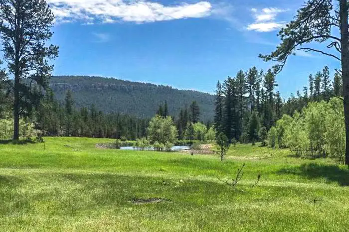
In South Dakota’s rolling hills, stunning mountains, wide canyons, and lush forests, there are plenty of locations to camp. RVing in South Dakota is a fantastic opportunity to completely see the state’s many attractions. And, while you’re there, the abundance of free camping in South Dakota allows you to completely immerse yourself in the state’s outdoors.
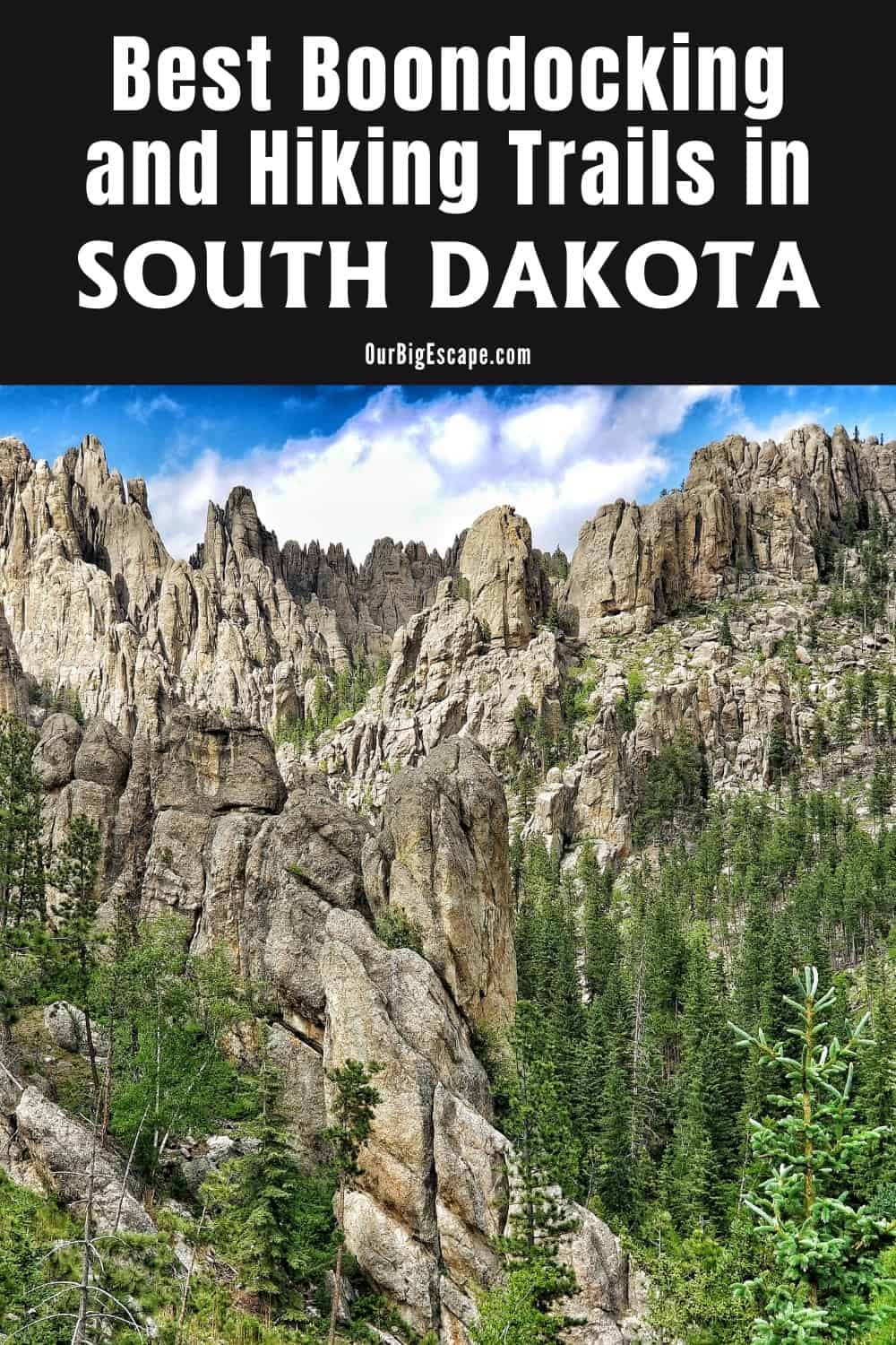
Mount Rushmore, one of the most iconic sights in the United States, is located in South Dakota. Aside from these four well-known faces, there is a breathtakingly magnificent environment to be found. Hike through the Black Hills’ rock formations and woodlands, or visit Badlands National Park to enter a wild and strange environment.
Want more ideas to round-out your trip to the North-Central States?
► Iowa, Minnesota, Nebraska, North Dakota, South Dakota ◄
- 38 Top Iowa Boondocking Campsites With Maps
- 85 Awesome Minnesota Boondocking Areas Plus Maps
- 153 Free Nebraska Boondocking Sites Including Maps
- 106 Best North Dakota Boondocking Spots Along With Maps
- 67 Amazing South Dakota Boondocking Spaces And Maps
21 Eastern Section of South Dakota Boondocking
Jump directly to the 46 Western Section of South Dakota Camping Sites
check out our video
1. Vermillion Rest Area
Address
Burbank, South Dakota
GPS: 42.783525, -96.786883
Elevation: 1198′
Management: Public – Rest Area
South Dakota boondocking spaces with nice clean restrooms.The usual noise from interstate traffic and truckers/campers pulling through but good for an overnighter. Highway Patrol office right there and squad cars frequently in and out. Fuel and coffee on the other side of I29.
2. Valley Springs Information Center (eastbound)
Address
Valley Springs, South Dakota
GPS: 43.60883, -96.4611
Elevation: 1444′
Management: Public – Rest Area (Unofficial)
The road in is Paved. The maximum RV length at Valley springs information center (eastbound) is unlimited. You may stay a couple of hours at Valley springs information center (eastbound). Free South Dakota camping sites.
3. Ward Rest Area I-29 Exit 121
Address
47292 223rd St
Flandreau, South Dakota
GPS: 44.1549, -96.75599
Elevation: 1650′
Management: Public – Rest Area (Unofficial)
The road in is Paved. Ward Rest Area I-29 Exit 121 is open all year. There are 16-29 South Dakota dispersed campsites at this location and the maximum RV length is 45 feet. You may stay a couple of hours at Ward Rest Area I-29 Exit 121.
4. Britton City Park
Address
1201-1209 423rd Ave
Britton, South Dakota
GPS: 45.795718, -97.750618
Elevation: 1358′
Management: Public – City Park
First 2 days free then $14.00 per night. South Dakota boondocking spaces.
5. Buffalo South LUA
Address
County Highway 16
Eden, South Dakota
GPS: 45.607385, -97.316066
Elevation: 1844′
Management: Public – State Park
Free South Dakota camping sites. Reservations are not accepted at this campsite. Nothing more than a boat launch, so stay out of the way. There’s a spot just before the launch area to the left (on the water), but I tucked off to the side of the launch area in my camper van.
6. Waubay City
Address
524 East Lakeshore Drive
Waubay, South Dakota
GPS: 45.34148, -97.296781
Elevation: 1804′
Management: Public – City Park
Waubay City is open all year. Free South Dakota dispersed campsites within a Waubay city managed park. If you arrive during the day don’t let the highway noise deter you from staying. At night there was like little or no traffic, very quiet. Only got one bar on cell (att) and didn’t want to hoist the booster due to the terrific winds blowing. Clean, well manicured grass, new picnic tables and a one holer long drop toilet.
7. Tulare City Park
Address
US Hwy 281
Tulare, South Dakota
GPS: 44.737068, -98.504715
Elevation: 1316′
Management: Public – City Park (Official)
The road in is Paved. There are 1-5 South Dakota boondocking spaces at this location. The City Park is a block off of US Hwy 281 has three campsites with 30amp electrical hookups for camping and lots of room in which to relax or run and play. No dump station or showers. Old-style toilets. There are also horseshoe pits and volleyball poles in the park. GPS approximate.
8. Twin Lakes, SD
Address
Woonsocket, South Dakota
GPS: 43.96584, -98.32927
Elevation: 1318′
Management: Public – Fish and Wildlife Service (Official)
The road in is Paved. There are 6-15 Free South Dakota camping sites at this location and the maximum RV length is 15 feet. You may stay None posted at Twin Lakes, SD. If you really want solitude, 6 miles outside of Woonsocket is Twin Lakes. Nice secluded free grass tree shaded sites, right next to lake. Primitive toilet, no water/no electric. Fish and wild life managed.
9. Armour’s Lions Park
Address
Miltimore St
Armour, South Dakota
GPS: 43.322548, -98.343661
Elevation: 1516′
Management: Public – City Park (Official)
The road in is Paved. There are 6-15 South Dakota dispersed campsites at this location and the maximum RV length is unlimited. Cutest little town with beautiful Lion’s Park. Four pull through spots with 30 and 50 amp connections. 5 or 6 back in, van, or tent spots with electric also. The Lion’s club also offers a couple cabins for rent here also. Showers and toilets available.
10. Running Water Access
Address
5689-5727 Main Street
Springfield, South Dakota
GPS: 42.770813, -97.97922
Elevation: 1211′
Management: Public – State Park
Free South Dakota boondocking spaces. Reservations are not accepted at this campsite.
11. Lesterville LUA
Address
430th Avenue
Yankton, South Dakota
GPS: 42.866689, -97.586036
Elevation: 1283′
Management: Public – State Park
Free South Dakota camping sites. First come -> first camped. No reservations are accepted. Followed the dirt road to the entrance to Lesterville. The gate was closed with a private property sign. Off to the side their is a Lesterville can only be accessed by foot from here sign. I backed out all the way. The road was very soft save for the single path. I did not see any places to pull off and park for the walk in.
12. Gunderson
Address
North Street
Centerville, South Dakota
GPS: 43.122969, -96.96391
Elevation: 1214′
Management: Public – City Park
This park is managed by the city of Centerville. South Dakota dispersed campsites.
13. Fort Thompson Recreation Area
Address
Fort Thompson, South Dakota
GPS: 44.056389, -99.442917
Elevation: 1369′
Management: Public – Corps of Engineers (Official)
Below dam east side of the spillway. There are lots of trees. The sites are large. Nice showers
There are 6-15 South Dakota boondocking spaces at this location.
14. North Shore Recreation Area
Address
Fort Thompson, South Dakota
GPS: 44.066185, -99.475708
Elevation: 1453′
Management: Public – Corps of Engineers (Official)
There are 16-29 Free South Dakota camping sites at this location. 24 sites. primitive. 1 mile to Water and dump site Playground, picnic shelter, swimming beach, boat ramp, fish cleaning table. Gravel road for about 1 mile on east side of Sharpe Lake.
15. Sutton Bay LUA
Address
Sutton Bay Road
Agar, South Dakota
GPS: 44.880033, -100.358527
Elevation: 1627′
Management: Public – State Park
South Dakota dispersed campsites. First come -> first served. No reservations accepted. Nice area down by the lake, but no cell service there. Good cell service up on the plateau.
16. Shaw Creek LUA
Address
Point of View Road
Herreid, South Dakota
GPS: 45.798386, -100.342944
Elevation: 1624′
Management: Public – State Park
Free South Dakota boondocking spaces. This campsite does not use a reservation system. First come, first served.
17. Dodge Draw LUA
Address
Unnamed Road
Gettysburg, South Dakota
GPS: 45.176107, -100.265128
Elevation: 1627′
Management: Public – State Park
Free South Dakota camping sites. First come -> First Camped. Reservations not accepted.
18. LeBeau LUA
Address
Unnamed Road
Selby, South Dakota
GPS: 45.277198, -100.264805
Elevation: 1621′
Management: Public – State Park
South Dakota dispersed campsites. First come -> First Camped. Reservations not accepted.
19. Roscoe City
Address
305 Williams Street
Roscoe, South Dakota
GPS: 45.454404, -99.334373
Elevation: 1818′
Management: Public – City Park
Roscoe City is open May-Sep. Roscoe maintains this city park and free South Dakota boondocking spaces.
20. Herreid City
Address
108th Street
Herreid, South Dakota
GPS: 45.825764, -100.069331
Elevation: 1683′
Management: Public – City Park
Free South Dakota camping sites.
South Dakota Camping Sites
In South Dakota, boondocking allows you to visit vast underground caves, watch archaeologists dig woolly mammoth bones, and soak in a natural hot spring. There are remnants of Native American culture, Gold Rush history, and modern agribusiness everywhere.
Dispersed campers must pitch their tents at least 12 miles away from any built areas, and they must be 100 feet away from any road, stream, or trail. Custer State Park and Mt. Rushmore National Monument are both close to the Black Hills National Forest.
46 Western Section of South Dakota Camping Sites
Jump directly to the 21 Eastern Section of South Dakota Boondocking
1. Lesterville LUA
Address
430th Avenue
Yankton, South Dakota
GPS: 42.866689, -97.586036
Elevation: 1283′
Management: Public – State Park
Free South Dakota boondocking spaces. First come -> first camped. No reservations are accepted. Followed the dirt road to the entrance to Lesterville. The gate was closed with a private property sign. Off to the side their is a Lesterville can only be accessed by foot from here sign. I backed out all the way. The road was very soft save for the single path. I did not see any places to pull off and park for the walk in.
2. Running Water Access
Address
5689-5727 Main Street
Springfield, South Dakota
GPS: 42.770813, -97.97922
Elevation: 1211′
Management: Public – State Park
Free South Dakota camping sites. Reservations are not accepted at this campsite.
3. Dude Ranch
Address
43.782220,-99.426297
Chamberlain, South Dakota
GPS: 43.781316, -99.426738
Elevation: 1374′
Management: Public – Fish and Wildlife Service (Official)
The road in is Gravel and 3 miles from a paved road. Dude Ranch is open ?. There are 6-15 South Dakota dispersed campsites at this location and the maximum RV length is unlimited. You may stay ? at Dude Ranch. Public boat landing and open camping area, picnic tables, fire pits and an out house. Right on the Missouri River. About 3 miles off of Int 90. Road in was gravel and very wash boarded but passable even though it had just rained heavily.
4. Oacoma Flatts
Address
Oacoma, South Dakota
GPS: 43.793259, -99.393535
Elevation: 1365′
Management: Public – County Park (Official)
The road in is Gravel. There are 6-15 South Dakota boondocking spaces at this location and the maximum RV length is unlimited. You may stay 7 at Oacoma Flatts. Free sites (up to 7 nights) along the Missouri River. Walking distance to city park where you can find toilets, picnic tables and fire pits and grills. Peaceful.
5. Chamberlain Riverside Camp
Address
Chamberlain, South Dakota
GPS: 43.79596, -99.34744
Elevation: 1371′
Management: Public (Unofficial)
South side of the bridge (I90). Dirt road down to the riverbank. Depending on road conditions, I would be wary about bringing a trailer. Short but somewhat steep and not straight trail down. May need 4×4. Free South Dakota camping sites.
6. Byre Lake
Address
43.92999 latitude, -99.83372 longitude
Kennebec, South Dakota
GPS: 43.929859, -99.833858
Elevation: 1670′
Management: Public – Fish and Wildlife Service (Official)
The road in is Gravel and 2 miles from a paved road. Byre Lake is open Year Round. There are 6-15 South Dakota dispersed campsites at this location and the maximum RV length is unlimited. You may stay 5 Days at Byre Lake. This is a great camping area. Very peaceful lake. Lots of bird life- water and land birds. We kayaked on the lake. The sunset and stars were amazing.
7. Isabel Lake
Address
Isabel, South Dakota
GPS: 45.436944, -101.417766
Elevation: 2264′
Management: Public – Fish and Wildlife Service
Nice site with trees, picnic tables, boat launch. Free South Dakota boondocking spaces.
8. Little Moreau State Recreation Area
Address
Timber Lake, South Dakota
GPS: 45.346926, -101.094338
Elevation: 2043′
Management: Public (Official)
Little Moreau State Recreation Area is open all year. There are 1-5 Free South Dakota camping sites at this location. You may stay 14 at Little Moreau State Recreation Area.
9. Minneconjou Park LUA
Address
Unnamed Road
Fort Pierre, South Dakota
GPS: 44.752947, -100.905509
Elevation: 1624′
Management: Public – State Park
South Dakota dispersed campsites. This campsite does not use a reservation system. First come, first served.
10. Sherif Dam
Address
Draper, South Dakota
GPS: 44.108388, -100.425776
Elevation: 1916′
Management: Public – Forest Service (Official)
The road in is Dirt. There are 6-15 South Dakota boondocking spaces at this location and the maximum RV length is 25 feet. . Free camping at Sherif Dam in the Ft Pierre National Grasslands. The road going is has some pretty deep ruts but if you are an adventurist you can go around that spot. Not a good place for large RV’s.
11. Richland Dam Rec. Area
Address
Draper, South Dakota
GPS: 44.147008, -100.408344
Elevation: 1888′
Management: Public – Forest Service (Official)
Richland Dam Rec. Area is open year-round. There are 30 or more Free South Dakota camping sites at this location and the maximum RV length is 45 feet. You may stay 14 at Richland Dam Rec. Area. Free camping at Richland Dam in the Ft Pierre National Grassland. Large open field which is mowed several times a year. Access to Richland Dam for fishing.
12. White River
Address
White River, South Dakota
GPS: 43.564464, -100.74144
Elevation: 2146′
Management: Public – City Park (Official)
The road in is Gravel and 150′ miles from a paved road. There are 6-15 South Dakota dispersed campsites at this location and the maximum RV length is 35 feet. No electricity or water at sites, there are 2 pit toilets. Water is available in the middle of the camp area. Clean level grassy sites back in only. (RVs could nose-in) Would be difficult for anything longer than 30 or 35′ pull trailer.
13. Lacreek NWR – Little White River RA
Address
Unnamed Road
Martin, South Dakota
GPS: 43.171299, -101.544893
Elevation: 3015′
Management: Public – Fish and Wildlife
Free South Dakota boondocking spaces. No reservations. First come, first served. There are several spots right on the lake, which is surrounded by cattail. The fields around the lake are all farms. It was beautiful here. The drive in was dirt with tricky spots, Recommend 4 wheel and lifted but a skilled driver could take a sedan. We actually saw one go by.
14. Hodson Memorial Park
Address
Major Allen Street
Martin, South Dakota
GPS: 43.168881, -101.730934
Elevation: 3307′
Management: Public – City Park (Official)
Hi, I’m not sure what services are available. Free South Dakota camping sites.
15. Brooks Memorial Park.
Address
Vetal, South Dakota
GPS: 43.176811, -101.731384
Elevation: 3314′
Management: Public – City Park (Official)
RV parking and hookups available. South Dakota dispersed campsites.
16. Buffalo Gap National Grasslands
Address
708 Main St / PO Box 425 Wall, SD 57790
Oelrichs, South Dakota
GPS: 43.170786, -103.165607
Elevation: 3412′
Management: Public – Forest Service (Official)
The road in is Dirt. There are 30 or more Free South Dakota boondocking spaces at this location and the maximum RV length is unlimited. These National Grasslands are amazing! There’s practically an infinite number of boondocking ‘sites’ available with vast miles and miles of rolling grass hills and meadows. It’s managed by the National Forest Service, and it’s all open to the public (in fact, being national land, we all jointly own it). The full 369-degree views are absolutely stunning, and for me this is as close to a perfect boondocking location that I’ve ever experienced.
17. Sheps Canyon
Address
Hot Springs, South Dakota
GPS: 43.307671, -103.439125
Elevation: 3192′
Management: Public – State Park (Official)
The road in is Gravel and 10 miles from a paved road. Sheps Canyon is open All year. There are 1-5 Free South Dakota camping sites at this location. There are four primitive campsites on the WEST side of the lake which are free.
18. Bombing Range Rd
Address
Bombing Range Road
Scenic, South Dakota
GPS: 43.712661, -102.520852
Elevation: 2805′
Management: Public – Forest Service
Free South Dakota dispersed campsites in the Nebraska National Forest’s Wall Ranger District. This campsite does not use a reservation system. First come, first served.
19. Sage Creek Campground
Address
Sage Creek Road
Wall, South Dakota
GPS: 43.894085, -102.414063
Elevation: 2549′
Management: Public – National Park Service (Official)
The road in is Gravel and 13 miles from a paved road. Sage Creek Campground is open Year Round. There are 1-5 Free South Dakota boondocking spaces at this location and the maximum RV length is 18′. You may stay 14 days at Sage Creek Campground. This “primitive camping” area in Badlands National Park caters to tenters, but it can accommodate smaller RVs. The road makes big loop with parking all around the inside, and tent sites and picnic tables in the middle. Bison wander the area grazing.
20. Badlands National Park
Address
Porcupine, South Dakota
GPS: 43.563956, -102.888019
Elevation: 3196′
Management: Public – National Park Service (Official)
The road in is Dirt. There are 1-5 Free South Dakota camping sites at this location and the maximum RV length is 45 feet. Southwest edge of the Badlands National Park, in a small area where the Park touches BIA-41. There is a small 100′ by 100′ area of mowed grass that over looks the Badlands.
21. French Creek Campground
Address
E French Creek Rd. Fairburn, SD
Fairburn, South Dakota
GPS: 43.6622, -103.0227
Elevation: 2898′
Management: Public – Forest Service
The road in is Dirt. There are 6-15 South Dakota dispersed campsites at this location. Campground has 8-10 tent sites in a fenced area. Vault toilet and garbage cans are in this area. There is parking in front of the tent area for cars/trucks and across the road for RV’s or horse trailers. Very busy spot for rockhounds with agate beds within walking distance.
22. Rifle Pit
Address
U.S. 385
Hot Springs, South Dakota
GPS: 43.598423, -103.52145
Elevation: 4623′
Management: Public – Forest Service
Free South Dakota boondocking spaces located within the Black Hills National Forest’s Hell Canyon Ranger District. This site is not closed! The left side of the road, not the right, is open. Follow the road sign marked “Rifle Pit.” The right side is closed due to sapling growth. A good place to sleep for the night, but that’s about it.
23. FR343.1a
Address
Custer, South Dakota
GPS: 43.716145, -103.570942
Elevation: 5522′
Management: Public – Forest Service
The road in is Dirt. There are 1-5 Free South Dakota camping sites at this location and the maximum RV length is 25 feet. You may stay 14 days at FR343.1a. Dispersed camping at the start of a closed road. Rough road coming in. High clearance. Vans” small trailers and truck campers. Thia is a a seriously beautiful area but due ti a recent thinning there are log lpiles everywhere. Line of sight to att cell tower
24. Little Moreau State Recreation Area
Address
Timber Lake, South Dakota
GPS: 45.346926, -101.094338
Elevation: 2043′
Management: Public (Official)
Little Moreau State Recreation Area is open all year. There are 1-5 South Dakota dispersed campsites at this location. You may stay 14 at Little Moreau State Recreation Area.
25. Lower French Creek
Address
Custer, South Dakota
GPS: 43.754492, -103.52012
Elevation: 5092′
Management: Public – Forest Service (Unofficial)
Just alongside the road with a state park sign in the middle. 4×4 is recommended but my two wheel did just fine. Be careful. Free South Dakota boondocking spaces.
26. Comanche Park National Forest Campground
Address
Custer, South Dakota
GPS: 43.73459, -103.714532
Management: Public – Forest Service (Official)
The road in is Paved. Comanche Park National Forest Campground is open Late October – Mid May. There are 1-5 Free South Dakota camping sites at this location and the maximum RV length is 35 feet. You may stay 14 Days at Comanche Park National Forest Campground. Many Black Hills National Forest Campgrounds are free during the off season. This one is $16/Night for single unit, $2/Night for extra vehicle in season. We stopped at the National Forest Headquarters and the ranger gave us a map of all the campgrounds.
27. Custer State Park Outskirts – A PASS or PERMIT is required at this campsite.
Crazy Horse, South Dakota
GPS: 43.779467, -103.505703
Elevation: 5325′
Get Directions
Management: Private (Official)
South Dakota dispersed campsites in national Forest free no water no services this is a free camp site in Custer state park you must pay fee (20 $ for a week).
28. Wrinkled Rock Climbing Area
Address
Keystone, South Dakota
GPS: 43.887837, -103.469496
Elevation: 5194′
Management: Public – Forest Service (Official)
The road in is Paved. Wrinkled Rock Climbing Area is open all year. There are 6-15 South Dakota boondocking spaces at this location and the maximum RV length is 15 feet. You may stay 14 at Wrinkled Rock Climbing Area. Dispersed tent camping only or place to park a van or somthing, it says “Restrictions: No large vehicles/RVs” on the USFS web site.
29. Spring Creek
Address
Crazy Horse, South Dakota
GPS: 43.86594, -103.65248
Elevation: 5463′
Management: Public – Forest Service (Official)
The road in is Gravel and 1.7 miles from a paved road. Spring Creek is open Year round. There are 1-5 Free South Dakota camping sites at this location and the maximum RV length is 15 feet. You may stay 14 days at Spring Creek. Dispersed camping in the Black Hills National Forest. Several sites along Spring Creek Rd including this one. Nice primitive site beside Spring Creek, private.
30. Bear Mountain Hill Top
Address
Custer, South Dakota
GPS: 43.867203, -103.753686
Elevation: 7011′
Management: Public – Forest Service (Official)
The road in is Gravel and 12 miles from a paved road. There are 1-5 South Dakota dispersed campsites at this location and the maximum RV length is 35 feet. You may stay 14 at Bear Mountain Hill top. Real hard finding this spot, but it worked out for our 37ft 5th wheel. Stayed here 8 nights with no problems. Lots of deer and no one around at night. Real remote. Clear view of sun for solar power.
31. Centennial Trailhead Samulies
Address
US-16
Silver City, South Dakota
GPS: 43.928375, -103.487898
Elevation: 5062′
Management: Public – Forest Service (Unofficial)
Just a quick pull off hwy 16 east of hill city south Dakota. Good one night stop..fit 34ft c class spots for tents just in the forest. Free South Dakota boondocking spaces.
32. Mystic Road and 241
Address
Hill City, South Dakota
GPS: 43.96416, -103.64216
Elevation: 5541′
Management: Public – Forest Service (Unofficial)
You may stay 14 days in Free South Dakota camping sites at Mystic Road and 241. Access from a well maintained gravel road. Last 1/4 mi may get muddy. Level clearing and access to nearby trails and forest service roads. Black Hills National Forest land. 14 day stay limit. No cell service. Nearest facilities about 6 miles away.
33. Taylor Ranch RD
Address
Taylor Ranch RD
Rapid City, South Dakota
GPS: 43.997445, -103.449861
Elevation: 4606′
Management: Public – Forest Service (Official)
The road in is Gravel and .25 miles from a paved road. There are 1-5 South Dakota dispersed campsites at this location and the maximum RV length is unlimited. You may stay none at Taylor Ranch RD. This is a nice grassy meadow only 1/4 mile from paved road. Big rig friendly.
34. Next to Love’s #602
Address
Box Elder, South Dakota
GPS: 44.12134, -103.05511
Elevation: 3081′
Management (Unofficial)
The road in is Paved. Next to Love’s #602 is open year round. There are 30 or more Free South Dakota boondocking spaces at this location and the maximum RV length is unlimited. You may stay overnight at Next to Love’s #602. Next to the Love’s truckstop in Box Elder South Dakota.Reagen St it’s a quiet culdesack right next to the truckstop. No one bothered us and there were a couple other RVer’s and a couple car campers. Nice and quiet unlike the busy truckstop. We slept like babies!
35. Nemo Forest Road 678
Address
Nemo, South Dakota
GPS: 44.203491, -103.517102
Elevation: 4764′
Management: Public – Forest Service (Official)
The road in is Gravel and 3 miles from a paved road. There are 1-5 Free South Dakota camping sites at this location and the maximum RV length is unlimited. Dispersed camping in Black Hills Forest right outside Nemo. About a mile up a dirt road, just past where the Centennial Trail crosses. We made it fine with a 2 WD van, but I wouldn’t recommend a small car as you’ll need some clearance.
36. Castle Peak Rd Campsites
Address
Hill City, South Dakota
GPS: 44.068062, -103.718623
Elevation: 5262′
Management: Public – Forest Service (Official)
The road in is Dirt and 6 miles from a paved road. Castle Peak Rd Campsites is open Year round weather permitting. There are 6-15 South Dakota dispersed campsites at this location and the maximum RV length is 25 feet. You may stay 14 days at Castle Peak Rd Campsites.
37. Long Draw
Address
Lead, South Dakota
GPS: 44.257245, -103.841618
Elevation: 5712′
Management: Public – Bureau of Land Management (Unofficial)
The road in is Gravel and 0.1 miles from a paved road. There are 1-5 Free South Dakota boondocking spaces at this location and the maximum RV length is 35 feet. You may stay 14 at Long Draw. If the other spot on Hanna Road is full or you can’t get in due to the steep entrance here’s another option. Just a few 100 yards further, after a few houses, is Long Draw Rd on the right.
38. Hanna Dispersed Campsite
Address
44.265919,-103.847652
Lead, South Dakota
GPS: 44.265985, -103.847592
Elevation: 5629′
Management: Public – Forest Service (Unofficial)
The road in is Paved. Hanna Dispersed Campsite is open ?. There are 1-5 Free South Dakota camping sites at this location and the maximum RV length is 25 feet. You may stay ? at Hanna Dispersed Campsite. Dispersed campsite in the Black Hills National Forest, just down the road From the Hanna Forest Service Campground and right on a little river.
39. Pull Off Black Hills National Forest
Address
Lead, South Dakota
GPS: 44.38848, -103.75863
Elevation: 5525′
Management: Public – Forest Service (Unofficial)
Primitive, South Dakota dispersed campsites with established stone firering with AMAZING VIEWS OF DEADWOOD! No signs posted. The site also has an area for a little hike for about 10-15 min.
40. MT Roosevelt- Black Hills National Forest.
Address
Deadwood, South Dakota
GPS: 44.395688, -103.745712
Elevation: 5371′
Management: Public – Forest Service (Official)
The road in is Gravel and 2 miles from a paved road. There are 1-5 Free South Dakota boondocking spaces at this location. At the top of the Mt Roosevelt drive there are many pull offs for primitive camping. Signs warn against campfires but no indication camping isn’t allowed. Pot toliet at the trail head.
41. Northern Black Hills General
Address
Spearfish, South Dakota
GPS: 44.394052, -104.012053
Management: Public – Forest Service (Official)
Free South Dakota camping sites in the Black Hills National Forest anywhere unless posted otherwise (typically you can’t camp along paved roads, such as in Spearfish Canyon) but nearly any dirt road leading from Spearfish, Whitewood, Lead, Deadweood, Sturgis and Sundance Wyoming.
42. Tinton Rd
Address
Spearfish, South Dakota
GPS: 44.44739, -103.91734
Elevation: 4869′
Management: Public – Forest Service (Official)
South Dakota dispersed campsites off FS Rd 134/6261K. 14 Day stay limit.
43. Rocky Point Free Zone
Address
Belle Fourche, South Dakota
GPS: 44.700713, -103.72967
Elevation: 2979′
Management: Public – National Park Service (Official)
The road in is Gravel and 1 miles from a paved road. Very basic dirt road Free South Dakota boondocking spaces for overnight or a few days of boondocking. Nothing special at al. The paid section is just up the road if you need water and electric. A short drive into town for supplies. There is a small river next to the road for fishing if desired.
44. Orman Dam
Address
Fruitdale, South Dakota
GPS: 44.73124, -103.72118
Elevation: 2979′
Management: Public – State Reserve Land (Official)
The road in is Gravel and One miles from a paved road. There are 30 or more Free South Dakota camping sites at this location and the maximum RV length is unlimited. There are two areas. One are is past the gatehouse and costs money. If you turn left at the gatehouse and go about a half mile there will be LOTS of free campsites.
45. Reva Gap Campground
Address
Reva, South Dakota
GPS: 45.52578, -103.176628
Elevation: 3261′
Management: Public – Forest Service (Official)
There are 1-5 South Dakota dispersed campsites at this location and the maximum RV length is 30′. Free RV camping in the Custer National Forest. Reva Gap Campground.
46. Isabel Lake
Address
Isabel, South Dakota
GPS: 45.436944, -101.417766
Management: Public – Fish and Wildlife Service
Nice site with trees, picnic tables, boat launch. Free South Dakota boondocking spaces.
You May Want to Join Our Boondocking Group on Facebook For More Information
You May Want to Join Our Campfire Recipes Group on Facebook For More Information
Check Out Our Pictures On Instagram – Our Big Escape.