In Arizona, there are numerous sites where you can camp for free. Because public areas such as national forests and BLM land make up about half of Arizona, there are literally hundreds of dispersed camping and boondocking options throughout the state.
Jump directly to the 95 East Central Section of Arizona Boondocking Locations
Jump directly to the 68 West Central Section of Arizona Dispersed Campsites
Jump directly to the 48 South East Section of Arizona Booondocking Areas
Jump directly to the 38 South West Section of Free Arizona Campsites
Arizona Boondocking Locations
Wherever you travel, free camping is fantastic, but free camping in Arizona is among the best. While many people imagine forested parks, mountain streams, and fields awash with wildflowers, the Arizona desert is just around the corner.
Within the towering Saguaros bathed in the surprising, brilliant colors of the desert terrain, you’ll find surreal beauty. Wide-open vistas of blue skies, sparkling stars, and an entire community of RVers have fallen in love with the austere beauty that only the Arizona desert can provide.
The Grand Canyon State has a reputation for scorching hot summers and a scarcity of water across the majority of the state. You won’t have to look far to discover a great boondocking place in Arizona, which has over 12.2 million acres of public property.
95 East Central Section of Arizona Boondocking Locations
Jump directly to the 68 West Central Section of Arizona Dispersed Campsites
Jump directly to the 48 South East Section of Arizona Booondocking Areas
Jump directly to the 38 South West Section of Free Arizona Campsites
1. Willard Springs Exit West
Address
Munds Park, Arizona
GPS: 34.975292, -111.686516
Elevation: 6693′
Management: Public – Forest Service (USDA) (Unofficial)
You may stay 14 nights in Arizona boondocking locations at Willard Springs Exit West.
2. Schnebly Hill Rd. FR226 Dispersed
Address
Munds Park, Arizona
GPS: 34.899088, -111.624227
Elevation: 6706′
Management: Public – Forest Service (Official)
The road in is Dirt and 3 miles from a paved road. Schnebly Hill Rd. FR226 Dispersed is open Spring to fall. There are 16-29 Arizona dispersed campsites at this location and the maximum RV length is 35 feet. You may stay 14 days at Schnebly Hill Rd. FR226 Dispersed.
3. Bell Trail Overflow
Address
Rimrock, Arizona
GPS: 34.67906, -111.71762
Elevation: 3901′
Management: Public – Forest Service (Official)
The road in is Paved. There are 6-15 Arizona booondocking areas at this location and the maximum RV length is unlimited. You may stay 14 at Bell Trail overflow and horse trailer parking.
4. FS Rd 618G
Address
Lake Montezuma, Arizona
GPS: 34.653767, -111.73365
Management: Public – Forest Service
The road in is Dirt. There are 6-15 Arizona boondocking locations at this site and the maximum RV length is 15 feet.
5. SR 179 East Dispersed Camping
Address
Forest Road 618
Lake Montezuma, Arizona
GPS: 34.6614, -111.713219
Elevation: 3899′
Management: Public – Forest Service (USDA) (Unofficial)
Free Arizona dispersed campsites in Coconino National Forest. No facilities – true boondocking. If you pack it in – pack it out!!! SR 179 East Dispersed Camping is open Year-round.
6. Agua Fria BLM
Address
Mayer, Arizona
GPS: 34.313595, -112.071297
Elevation: 3526′
Management: Public – Bureau of Land Management (Official)
The road in is 4×4 and 3 miles from a paved road. There are 1-5 Arizona booondocking areas at this location and the maximum RV length is 35 feet. You may stay 14 days at Agua Fria BLM.
7. Bumblebee BLM Horsethief Basin
Address
Black Canyon City, Arizona
GPS: 34.137554, -112.147808
Elevation: 2723′
Management: Public – Bureau of Land Management (Official)
The road in is Dirt and 5 miles from a paved road. There are 1-5 Arizona boondocking locations at this site and the maximum RV length is unlimited. You may stay 14 days at Bumblebee BLM Horsethief Basin.
8. Little Pan Staging and Camping Area
Address
Table Mesa Road
New River, Arizona
GPS: 34.004028, -112.161278
Elevation: 1929′
Management Unknown
The road in is Dirt. There are 30 or more Arizona dispersed campsites at this location and the maximum RV length is unlimited. You may stay 14 days at Little Pan Staging and Camping Area.
9. Marshall Lake
Address
FR 128 Flagstaff, AZ
Flagstaff, Arizona
GPS: 35.113169, -111.534233
Elevation: 7142′
Management: Public – Forest Service (Official)
The road in is Gravel and 1 miles from a paved road. Marshall Lake is open Early May-Mid Oct. There are 30 or more Arizona booondocking areas at this location and the maximum RV length is unlimited. You may stay 14 days at Marshall Lake.
10. Forest Service Road 135
Address
Happy Jack, Arizona
GPS: 34.797699, -111.408716
Elevation: 7651′
Management: Public – Forest Service (Official)
The road in is Dirt and 5 miles from a paved road. There are 1-5 Arizona boondocking locations at this site and the maximum RV length is 35 feet.
11. Chevelon Crossing
Address
Heber, Arizona
GPS: 34.590748, -110.787834
Elevation: 6167′
Management: Public – Forest Service (USDA) (Official)
Chevelon Crossing is open Year Round – May be inaccessible in winter. You may stay 14 Days in Arizona dispersed campsites at Chevelon Crossing.
12. Fossil Creek Rd
Address
Fossil Creek
Camp Verde, Arizona
GPS: 34.503315, -111.75045
Elevation: 3358′
Management: Public – Forest Service (USDA) (Unofficial)
The road in is Dirt and >1 miles from a paved road. Fossil Creek Rd is open Year Round. There are 1-5 Arizona booondocking areas at this location. You may stay 14 Nights at Fossil Creek Rd.
13. Chevelon Canyon Lake Campground
Address
Heber, Arizona
GPS: 34.509678, -110.840294
Elevation: 6958′
Management: Public – Forest Service (USDA) (Official)
Chevelon Canyon Lake Campground is open May – October. You may stay 14 Days in Arizona boondocking locations at Chevelon Canyon Lake Campground.
14. Chevelon Canyon Overview
Address
Arizona
GPS: 34.50603, -110.82823
Elevation: 6667′
Management: Public – Forest Service (Unofficial)
The road in is Dirt and 3 miles from a paved road. There are 1-5 Arizona dispersed campsites at this location and the maximum RV length is 15 feet.
15. Fr 9350
Address
Payson, Arizona
GPS: 34.340141, -110.982342
Elevation: 7621′
Management
Public – Forest Service (Official)
The road in is Dirt. Fr 9350 is open year round. There are 30 or more Arizona booondocking areas at this location and the maximum RV length is unlimited. You may stay 14 days at Fr 9350.
16. Control Rd Tonto Village
Address
Payson, Arizona
GPS: 34.35453, -111.19287
Elevation: 5630′
Management: Public – Forest Service (Official)
The road in is Paved. Control Rd Tonto Village is open Any. There are 6-15 Arizona boondocking locations at this site and the maximum RV length is unlimited. You may stay Any at Control Rd Tonto Village.
17. Flowing Spring – Tonto National Forest
Address
Payson, Arizona
GPS: 34.302837, -111.352394
Elevation: 4574′
Management: Public – Forest Service (USDA) (Official)
Flowing Spring – Tonto National Forest is open Year Round. The maximum RV length at Flowing Spring – Tonto National Forest is 20′ Trailers. You may stay 14 Days in Arizona dispersed campsites at Flowing Spring – Tonto National Forest.
18. Alderwood
Address
Nf-329
Young, Arizona
GPS: 34.205875, -110.980537
Elevation: 5230′
Management: Public – Forest Service
Alderwood is open May-Oct. The maximum RV length at Alderwood is 16 feet. This moderately-used campground is appreciated for its solitude. Arizona booondocking areas well-shaded. No drinking water available.
19. Dispersed camping on NF 375B
Address
Payson, Arizona
GPS: 34.182451, -111.323247
Management: Public – Forest Service (Official)
The road in is Dirt and Less than 5 miles from a paved road. There are 6-15 Arizona boondocking locations at this site.
20. Mt Ord
Address
Sunflower, Arizona
GPS: 33.912159, -111.407761
Elevation: 6720′
Management: Public – Forest Service (USDA) (Unofficial)
The road in is Gravel and 6 miles from a paved road. You may stay 14 days in Arizona dispersed campsites at Mt Ord.
21. Juniper Dispersed
Address
North Seven Springs Road
Scottsdale, Arizona
GPS: 33.978089, -111.865581
Elevation: 3396′
Management: Public – Forest Service
Free Arizona booondocking areas in the Tonto National Forest’s Cave Creek Ranger District. First come -> first served. No reservations accepted. The maximum RV length at Juniper Dispersed is 16 feet.
22. Alderwood
Address
Nf-329
Young, Arizona
GPS: 34.205875, -110.980537
Elevation: 5230′
Management: Public – Forest Service
Arizona boondocking locations, well-shaded. No drinking water available. Alderwood is open May-Oct. The maximum RV length at Alderwood is 16 feet
23. Colcord Ridge
Address
Nf-33
Young, Arizona
GPS: 34.262218, -110.843776
Elevation: 7635′
Management: Public – Forest Service
Arizona dispersed campsites on Colcord Ridge is open May-Oct. The maximum RV length at Colcord Ridge is 32 feet.
24. Upper Canyon Creek
Address
Nf-33
Young, Arizona
GPS: 34.288335, -110.803312
Elevation: 6555′
Management: Public – Forest Service
Arizona booondocking areas at Upper Canyon Creek is open May-Oct. The maximum RV length at Upper Canyon Creek is 16 feet.
25. Airplane Flat
Address
Nf-33
Young, Arizona
GPS: 34.283394, -110.809602
Elevation: 6565′
Management: Public – Forest Service
Arizona boondocking locations at Airplane Flat is open May-Oct. The maximum RV length at Airplane Flat is 16 feet.
26. Valentine Ridge
Address
Nf-188
Young, Arizona
GPS: 34.243941, -110.798405
Elevation: 6640′
Management: Public – Forest Service
Arizona dispersed campsites on Valentine Ridge is open May-Oct. The maximum RV length at Valentine Ridge is 16 feet.
27. Cottonwood Camp OHV
Address
Fort McDowell, Arizona
GPS: 33.623351, -111.448141
Elevation: 1905′
Management: Public – Forest Service (Official)
The road in is Dirt. There are 6-15 Arizona booondocking areas at this location and the maximum RV length is unlimited.
28. Horse Trails Boondock
Address
Apache Junction, Arizona
GPS: 33.486552, -111.467494
Elevation: 2178′
Management: Public – Forest Service (Official)
Horse Trails Boondock is open year round. You may stay 14 days in Arizona boondocking locations at Horse Trails Boondock.
29. Apache Trail
Address
Mesa, Arizona
GPS: 33.535549, -111.378433
Elevation: 1867′
Management: Public – Forest Service (USDA) (Official)
The road in is Paved. Apache Trail is open Year Round. There are 1-5 Arizona dispersed campsites at this location. You may stay 14 days at Apache Trail.
30. Rose Creek
Address
Globe-Young Highway
Young, Arizona
GPS: 33.829693, -110.979597
Elevation: 5469′
Management: Public – Forest Service
Arizona booondocking areas located within the Tonto National Forest’s Pleasant Valley Ranger District.Rose Creek is open May-Oct. The maximum RV length at Rose Creek is 16 feet.
31. Sawmill Flats
Address
Globe-Young Highway
Young, Arizona
GPS: 33.813688, -110.983456
Elevation: 5797′
Management: Public – Forest Service
Arizona boondocking locations in Sawmill Flats is open May-Oct. The maximum RV length at Sawmill Flats is 16 feet.
32. Hog Canyon Overlook
Address
Young, Arizona
GPS: 33.74339, -110.967214
Elevation: 4144′
Management: Public – National Park Service (Unofficial)
The road in is Paved. Hog Canyon Overlook is open Always open, winter storms Can cause problems, but unlikely.. There are 1-5 Arizona dispersed campsites at this location and the maximum RV length is 35 feet. You may stay 14 days at Hog Canyon Overlook.
33. Jones water Campground
Address
17 Miles NE of Globe on US 60
Globe, Arizona
GPS: 33.592162, -110.642896
Elevation: 4190′
Management: Public – Forest Service (Official)
The road in is Gravel and less than 1 miles from a paved road. Jones water Campground is open All Year. There are 6-15 Arizona booondocking areas at this location and the maximum RV length is 15 feet. You may stay 14 Days at Jones water Campground.
34. H – Z Wash
Address
Globe-Young Highway
Roosevelt, Arizona
GPS: 33.624193, -110.934556
Elevation: 2254′
Management: Public – Forest Service
H – Z Wash is open all year. Free Arizona boondocking locations in the Tonto National Forest’s Tonto Basin Ranger District. First come -> first camped. No reservations are accepted.
35. Concho Lake, AZ Fish & Wildlife Site
Address
Concho, Arizona
GPS: 34.44129, -109.63173
Elevation: 6302′
Management: Public – Fish and Wildlife Service (Official)
The road in is Gravel and 1/4 mile miles from a paved road. Concho Lake, AZ Fish & Wildlife Site is open All Year. There are 6-15 Arizona dispersed campsites at this location and the maximum RV length is 35 feet. You may stay 7 at Concho Lake, AZ Fish & Wildlife Site.
36. Show Low Mogollon Rim Developmental
Address
Show Low, Arizona
GPS: 34.206696, -110.098562
Elevation: 6808′
Management: Public – Forest Service (Unofficial)
The road in is Dirt and 2 miles from a paved road. Show Low Mogollon Rim Developmental is open April-November. There are 30 or more Arizona booondocking areas at this location and the maximum RV length is 25 feet. You may stay 14 Days at Show Low Mogollon Rim Developmental.
37. Scott Reservoir
Address
Lakeside
Show Low, Arizona
GPS: 34.173465, -109.963188
Elevation: 6732′
Management: Public – Forest Service (Official)
The road in is Gravel and 1 miles from a paved road. Scott Reservoir is open April 1st through November 1st. There are 6-15 Arizona boondocking locations at this site. You may stay 5 days at Scott Reservoir.
38. Los Burros Campground
Address
Apache Sitgreaves National Forest, Arizona
GPS: 34.141178, -109.776392
Elevation: 7863′
Management: Public – Forest Service (Official)
The road in is Gravel and 7 miles from a paved road. Los Burros Campground is open May – Oct. There are 6-15 Arizona dispersed campsites at this location and the maximum RV length is unlimited. You may stay 14 at Los Burros Campground.
39. Dispersed camping near Big Lake
Address
Alpine, Arizona
GPS: 33.866893, -109.384101
Elevation: 8914′
Management: Public – Forest Service (Official)
The road in is Gravel. There are 1-5 Arizona booondocking areas at this location and the maximum RV length is 35 feet. You may stay 14 days at Dispersed camping near Big Lake.
40. Hulsey Lake
Address
Fr 8056
Nutrioso, Arizona
GPS: 33.93205, -109.161816
Elevation: 8602′
Management: Public – Forest Service
The maximum RV length at Hulsey Lake is 30 feet. Arizona boondocking locations.
41. Apache Trail
Address
Mesa, Arizona
GPS: 33.535549, -111.378433
Elevation: 1867′
Management: Public – Forest Service (USDA) (Official)
The road in is Paved. Apache Trail is open Year Round. There are 1-5 Arizona dispersed campsites at this location. You may stay 14 days at Apache Trail.
42. Mesquite Flats
Address
Apache Junction, Arizona
GPS: 33.545986, -111.337306
Elevation: 2860′
Management: Public – Forest Service (Unofficial)
The road in is Gravel and .1 miles from a paved road. There are 1-5 Arizona booondocking areas at this location and the maximum RV length is 25 feet. You may stay 14 days at Mesquite Flats.
43. Horse Trails Boondock
Address
Apache Junction, Arizona
GPS: 33.486552, -111.467494
Elevation: 2178′
Management: Public – Forest Service (Official)
Horse Trails Boondock is open year round. You may stay 14 days in Arizona boondocking locations at Horse Trails Boondock.
44. Jones Water Campground
Address
17 Miles NE of Globe on US 60
Globe, Arizona
GPS: 33.592162, -110.642896
Elevation: 4190′
Management: Public – Forest Service (Official)
The road in is Gravel and less than 1 miles from a paved road. Jones water Campground is open All Year. There are 6-15 Arizona dispersed campsites at this location and the maximum RV length is 15 feet. You may stay 14 Days at Jones water Campground.
45. Hewitt Canyon
Address
Arizona
GPS: 33.311903, -111.239671
Management: Public – Forest Service (Unofficial)
The road in is Dirt and 10 or so miles from a paved road. Hewitt Canyon is open Year Round. There are 1-5 Arizona booondocking areas at this location and the maximum RV length is 25 feet.
46. Sulphide Del Ray
Address
Unnamed Road
Globe, Arizona
GPS: 33.292745, -110.8679
Elevation: 6007′
Management: Public – Forest Service
Arizona boondocking locations at Sulphide Del Ray is open all year. The maximum RV length at Sulphide Del Ray is 20 feet.
47. Lower Pinal
Address
Forest Service Road 651
Globe, Arizona
GPS: 33.287362, -110.830314
Elevation: 7539′
Management: Public – Forest Service
Arizona dispersed campsites at Lower Pinal is open May-Nov. The maximum RV length at Lower Pinal is 20 feet.
48. Pinal & Upper Pinal
Address
Forest Road 651
Globe, Arizona
GPS: 33.284497, -110.822055
Elevation: 7680′
Management: Public – Forest Service
Pinal & Upper Pinal is open May-November. There are 16-29 Arizona booondocking areas at this location and the maximum RV length is 20 feet. You may stay 14 days at Pinal & Upper Pinal.
49. Pioneer Pass
Address
FR 112
Globe, Arizona
GPS: 33.28062, -110.796776
Elevation: 5810′
Management: Public – Forest Service (Official)
The road in is Gravel and 5.6 miles from a paved road. Pioneer Pass is open May. There are 16-29 Arizona boondocking locations at this site and the maximum RV length is 18 feet. You may stay 14 days at Pioneer Pass.
50. Shores Recreation Site
Address
Winkelman, Arizona
GPS: 33.021727, -110.738928
Elevation: 2002′
Management: Public – Bureau of Land Management (Official)
Facilities include parking, fire pits, and vault toilets. The Arizona dispersed campsites are not suitable for motor homes bigger than a small pickup camper. You may stay 14 days at Shores Recreation Site.
51. Christmas Recreation Site
Address
Winkelman, Arizona
GPS: 33.059946, -110.721704
Elevation: 2023′
Management: Public – Bureau of Land Management (Official)
Christmas Recreation Site is open Year Round. The maximum RV length at Christmas Recreation Site is 25 feet. You may stay 14 days in Arizona booondocking areas at Christmas Recreation Site.
52. Strayhorse Campground
Address
Highway 191
Clifton, Arizona
GPS: 33.550286, -109.317656
Elevation: 7774′
Management: Public – USDA Forest Service (Official)
The road in is Paved. Strayhorse Campground is open year round depending on the snow depth.. There are 6-15 Arizona boondocking locations at this site and the maximum RV length is 15 feet.
53. Honeymoon Campground – Apache-Sitgreaves NF
Address
Clifton, Arizona
GPS: 33.475349, -109.481209
Elevation: 5454′
Management: Public – Forest Service (USDA) (Official)
Honeymoon Campground – Apache-Sitgreaves NF is open May – September. You may stay 14 Days in Arizona dispersed campsites at Honeymoon Campground – Apache-Sitgreaves NF.
54. Lower Juan Miller Campground
Address
Clifton, Arizona
GPS: 33.267717, -109.340392
Elevation: 5730′
Management: Public – USDA Forest Service
Lower Juan Miller Campground is open unless access road is closed by snow. There are 1-5 Arizona booondocking areas at this location and the maximum RV length is 15 feet.
55. Granville Campground
Address
Highway 191
Clifton, Arizona
GPS: 33.187083, -109.381769
Elevation: 6729′
Management: Public – USDA Forest Service (Official)
Granville Campground is open April through November. There are 6-15 Free Arizona campsites at this site and the maximum RV length is 15 feet.
56. Bear Track Camp
Address
Clifton, Arizona
GPS: 33.10524, -109.09266
Elevation: 6198′
Management: Public – Forest Service (Official)
The road in is Gravel and 2.8 miles from a paved road. Bear Track Camp is open always. There are 6-15 Arizona dispersed campsites at this location and the maximum RV length is 25 feet.
57. Coal Creek Campground
Address
AZ 78
Clifton, Arizona
GPS: 33.103031, -109.060387
Elevation: 5696′
Management: Public – Forest Service (USDA) (Official)
The road in is Paved. Coal Creek Campground is open Year Round. The maximum RV length at Coal Creek Campground is 16′. You may stay 14 Days in Free Arizona campsites at Coal Creek Campground.
58. Blackjack Campground
Address
Clifton, Arizona
GPS: 33.059792, -109.079971
Elevation: 6237′
Management: Public – Forest Service (USDA) (Official)
Arizona boondocking locations in Blackjack Campground is open Year round weather permitting. The maximum RV length at Blackjack Campground is 16 feet.
59. FR618 Dispersed Camping
Address
Camp Verde, Arizona
GPS: 34.683243, -111.726266
Elevation: 3894′
Management: Public – Forest Service (Official)
Arizona dispersed campsites allowed when up to 300 feet from the road as long as you are 1 mile past the Day Use camping area.
60. Sunset Point Rest Area
Address
Black Canyon City, Arizona
GPS: 34.1858, -112.13465
Elevation: 3409′
Management: Public – Rest Area (Official)
Many Free Arizona campsites to park: overnight permitted just no camping. Multiple picnic spots with covered tables, restrooms, and vending machines. Beautiful view in the morning
61. Agua Fria National Monument Badger Springs Rec Area
Address
Black Canyon City, Arizona
GPS: 34.07609, -112.16223
Elevation: 2077′
Management: Public – Bureau of Land Management
Arizona boondocking locations right off Highway 17 in Black Canyon City, AZ. Large gravel area with trails. Can fit many RVs. Several had their slides out and were running generators.
62. North Little Grand Canyon Rd Site 1
Address
North Little Grand Canyon
New River, Arizona
GPS: 33.98958, -112.173981
Elevation: 1890′
Management: Public – Bureau of Land Management
Free Arizona dispersed campsites in the Bureau of Land Management Hassayampa District. First come -> first served. No reservations accepted.
63. W. Table Mesa Rd.
Address
Phoenix, Arizona
GPS: 33.985572, -112.149149
Elevation: 1988′
Management: Public – Bureau of Land Management (Official)
Free Arizona campsites on BLM LAND and State trust land. Stayed here in a SUV n Camper. Very BUSY, lots of shooting and heavy OHV usage.
64. Ashurst Lake Dispersed
Address
Happy Jack, Arizona
GPS: 35.024555, -111.449219
Elevation: 6941′
Management: Public – Forest Service (USDA) (Unofficial)
Free Arizona boondocking locations just before you reach the top of the hill on the way to Ashurst Lake. Call Mormon Lake Ranger District for more information. 928-774-1147
65. Anderson Meadow
Address
Arizona Trail
Flagstaff, Arizona
GPS: 34.982252, -111.484425
Elevation: 7244′
Management: Public – Forest Service
Free Arizona dispersed campsites within the Coconino National Forest’s Mormon Lake Ranger District. This is a high elevation location.
66. Gooseberry Springs Dispersed
Address
Fire Road 92
Happy Jack, Arizona
GPS: 34.821636, -111.431885
Elevation: 7466′
Management: Public – Forest Service (USDA) (Unofficial)
Free Arizona campsites in a meadow about 300 yards across, covered with dry grass and ringed with large ponderosa. A beautiful area (no facilities).
67. Stoneman Lake
Address
Stoneman Lake Road
Munds Park, Arizona
GPS: 34.777647, -111.524998
Elevation: 6841′
Management: Public – Forest Service
Arizona boondocking locations within the Coconino National Forest’s Red Rock Ranger District.
68. Apache Maid Mountain
Address
Forest Service Road 83
Happy Jack, Arizona
GPS: 34.735316, -111.52813
Elevation: 6447′
Management: Public – Forest Service
Free Arizona dispersed campsites located within the Coconino National Forest’s Red Rock Ranger District.
69. Jack’s Canyon
Address
Coconino, Arizona
GPS: 34.755798, -111.061531
Elevation: 6234′
Management: Public – Forest Service (USDA) (Unofficial)
Free Arizona campsites and unimproved at the canyon rim, where a 10 minute trail gets you to the routes. Please camp at obvious sites. Jack’s Canyon is open Year Round.
70. Cedar Flats Dispersed Camping
Address
Camp Verde, Arizona
GPS: 34.584919, -111.642599
Elevation: 5971′
Management: Public – Forest Service (Official)
4×4 recommended. State Road 260 to Forest Service Rd 618 to Cedar Flats Road (National Forest Rd 214). Arizona boondocking locations when you go past bald hill tank number 2.
71. Roundup Corral
Address
Happy Jack, Arizona
GPS: 34.51179, -111.540477
Elevation: 6293′
Management: Public – Forest Service (Official)
Arizona dispersed campsites just off highway, no bathrooms on BLM land. Can be a bit muddy after rain or snow.
72. Twentynine Mile Butte
Address
Flagstaff, Arizona
GPS: 34.48215, -111.42474
Elevation: 6919′
Management: Public
Area north of 260, west of the 87. Lots of Free Arizona campsites throughout this area with many OHV trails. Access to Clear Creek if you’re a hiker. Most roads are pretty well maintained – don’t require high clearance.
73. Larson Ridge
Address
Unnamed Road
Heber, Arizona
GPS: 34.386263, -110.859389
Elevation: 7398′
Management: Public – Forest Service
Free Arizona boondocking locations in the Apache-Sitgreaves National Forests’s Black Mesa Ranger District. This campsite does not use a reservation system. First come, first served. This is a high elevation location.
74. FR 169
Address
Forest Service Road 169
Payson, Arizona
GPS: 34.378526, -110.9552
Elevation: 7740′
Management: Public – Forest Service
Free Arizona dispersed campsites in the Apache-Sitgreaves National Forests’s Black Mesa Ranger District. This campsite does not use a reservation system. First come, first served. This is a high elevation location.
75. Control Road
Address
Payson, Arizona
GPS: 34.32142, -111.15145
Elevation: 5863′
Management: Public – Forest Service (Official)
Off hwy 260 north on control rd many Free Arizona campsites most with fire rings. this is on NFS land and marked on map provided bu ranger station
76. Diamond Point Dispersed Camping
Address
FR 64 – Diamond Point Road
Payson, Arizona
GPS: 34.292465, -111.194852
Elevation: 6227′
Management: Public – Forest Service (Official)
Free Arizona boondocking locations in the Tonto National Forest. The road in is Dirt
77. Little Green Valley Dispersed Camping
Address
FR405A
Payson, Arizona
GPS: 34.280369, -111.139412
Elevation: 5291′
Management: Public – Forest Service (USDA) (Unofficial)
Arizona dispersed campsites – No facilities. Suitable for RV, car, and tent camping. Larger rigs should be mindful of low branches in campsites. Area is often used by OHV enthusiasts.
78. Barnhardt Trailhead
Address
Payson, Arizona
GPS: 34.087665, -111.357929
Elevation: 3074′
Management: Public – Forest Service (Unofficial)
Free Arizona campsites at the Barnhardt trail head. You’ll see 5 or 6 fire rings made from rocks but plenty of room. A few other decent sites as you approach the trailhead. Great spot for tent camping before you hike in the Mazatzals.
79. Sheeps Bridge
Address
Unnamed Road
Carefree, Arizona
GPS: 34.07725, -111.708506
Elevation: 2057′
Management: Public – Forest Service
Sheeps Bridge is open all year. Free Arizona boondocking locations in the Tonto National Forest’s Cave Creek Ranger District. First come -> First Camped. Reservations not accepted.
80. Ocotillo
Address
Horseshoe Dam Road
Carefree, Arizona
GPS: 33.986096, -111.720894
Elevation: 2080′
Management: Public – Forest Service
Free Arizona dispersed campsites in the Tonto National Forest’s Cave Creek Ranger District. This campsite does not use a reservation system. First come, first served. The maximum RV length at Ocotillo is 40 feet.
81. Forest Road 171
Address
Payson, Arizona
GPS: 34.29412, -110.87687
Elevation: 7569′
Management: Public – Forest Service (Official)
14 day camping about 20 Free Arizona campsites numbered. Has a camp host that drives thru everyday and the Ranger too. It’s Dirt road. Has hiking, fire rings, pine trees, cell and Wi-Fi signal.
82. Young Road FR512 South
Address
Payson, Arizona
GPS: 34.28276, -110.85795
Elevation: 7625′
Management: Public – Forest Service (Official)
There is campsites all along Young Road or Forest Road 512. Arizona boondocking locations all along the road. You have to be 300 feet from the road. There are some fire rings made at some areas. 14 day stay you pack in you pack out.
83. Four Peaks OHV
Address
Fort McDowell, Arizona
GPS: 33.675444, -111.499214
Elevation: 2497′
Management: Public – Forest Service (Unofficial)
Most Arizona dispersed campsites have a fire ring. and the views are great. the weather is comparable to Phoenix. its a good place. lots of shooting though. most of that is off the second and first parking areas.
84. Carnero Lake
Address
Fs 117A
Greer, Arizona
GPS: 34.114423, -109.530786
Elevation: 9045′
Management: Public – State Park
Free Arizona campsites. This campsite does not use a reservation system. First come, first served. This is a high elevation location.
85. Whitewater Draw NWA
Address
Unnamed Road
Springerville, Arizona
GPS: 34.132573, -109.425711
Elevation: 7451′
Management: Public – Fish and Wildlife
Free Arizona boondocking locations. First come -> first served. No reservations accepted. This is a high elevation location.
86. FSR 117
Address
Unnamed Road
Greer, Arizona
GPS: 34.067523, -109.54546
Elevation: 9160′
Management: Public – Forest Service
Free Arizona dispersed campsites in the Apache-Sitgreaves National Forests’s Springerville Ranger District. Reservations are not accepted at this campsite. This is a high elevation location.
87. Road 118
Address
Forest Road 118
Greer, Arizona
GPS: 34.077373, -109.48521
Elevation: 8409′
Management: Public – Forest Service (Official)
Plenty of Free Arizona campsites on forest lands, less than a mile off the highway.
88. Road 112
Address
Greer, Arizona
GPS: 33.992299, -109.506749
Elevation: 9272′
Management: Public – Bureau of Land Management (Official)
Road 112 is a well maintained dirt road. Plenty of Arizona boondocking locations along the mountain overlooking a meadow. Some areas you can get cell service (Verizon).
89. West Fork
Address
Unnamed Road
Alpine, Arizona
GPS: 33.790062, -109.413184
Elevation: 7743′
Management: Public – Forest Service
Free Arizona dispersed campsites in the Apache-Sitgreaves National Forests’s Alpine Ranger District. No reservations. First come, first served. This is a high elevation location. West Fork is open May-Oct.
90. Four Peaks OHV
Address
Fort McDowell, Arizona
GPS: 33.675444, -111.499214
Elevation: 2497′
Management: Public – Forest Service (Unofficial)
Its bumpy. after that there are two more parking areas. the third one on the right has a state forest road that attaches to it, take that and there are miles of dirt roads and TONS of Free Arizona campsites. Pretty quiet during the week.
91. Mineral Mountian
Address
Gold Canyon, Arizona
GPS: 33.22795, -111.26085
Elevation: 2178′
Management: Public – Bureau of Land Management (Official)
Arizona boondocking locations on BLM and public land. The public land part there will be ATVs and people shooting practice targets etc. But not too bad and it is dispersed. The forat part is good for campers/rvs but the public land is only good for 4/all wheel drives overall a nice littke getaway under the stars and free place away from the city.
92. Apache Jct Dispersed
Address
East Hewitt Station Road
Gold Canyon, Arizona
GPS: 33.280078, -111.2681
Elevation: 2126′
Management: Public – Forest Service
Free Arizona dispersed campsites in the Tonto National Forest’s Mesa Ranger District. First come -> First Camped. Reservations not accepted.
93. Mescal Mountain OHV Area
Address
Unnamed Road
Kearny, Arizona
GPS: 33.062356, -110.896152
Elevation: 2047′
Management: Public – State Park
Free Arizona campsites. First come -> First Camped. Reservations not accepted.
94. Kelly Canyon
Address
Interstate 17
Flagstaff, Arizona
GPS: 35.059173, -111.68195
Elevation: 6837′
Management: Public – Forest Service
This free Arizona boondocking locations within the Coconino National Forest’s Mormon Lake Ranger District.
95. Rocky Park
Address
Forest Service Road 239
Munds Park, Arizona
GPS: 34.824855, -111.591109
Elevation: 6686′
Management: Public – Forest Service
Free Arizona dispersed campsites within the Coconino National Forest’s Mormon Lake Ranger District.
Arizona Dispersed Campsites
Hundreds of free campsites can be found along dirt roads and in established campgrounds from the Coconino National Forest to the Kofa National Wildlife Refuge, thanks to all of the public and federal acreage across the Grand Canyon State. Hundreds of thousands of people visit Arizona every year for free camping, which includes both desert and woodland.
Stay limits for most free camping in Arizona are 14 days within a 25-mile radius at any time during a 28-day period. You can stay at another campsite for another 14 days, but it must be at least 25 miles away from your prior location to avoid receiving a ticket.
Boondocking in Arizona is also a great way to tour the national parks of the United States. Grand Canyon, Petrified Forest, and Saguaro are the three in the state. There are about a dozen national monuments in Arizona. When you factor in the fifty or so Bureau of Land Management (BLM) wilderness areas, it’s practically hard not to find a fun boondocking spot.
68 West Central Section of Arizona Dispersed Campsites
Jump directly to the 95 East Central Section of Arizona Boondocking Locations
Jump directly to the 48 South East Section of Arizona Booondocking Areas
Jump directly to the 38 South West Section of Free Arizona Campsites
1. BLM South of Kingman Arizona
Address
Kingman, Arizona
GPS: 35.024675, -114.096434
Elevation: 2589′
Management: Public – Bureau of Land Management (Unofficial)
The road in is Dirt and 2 miles from a paved road. There are 1-5 Arizona boondocking locations at this site.
2. Hualapai Mountain Road BLM
Address
Kingman, Arizona
GPS: 35.162607, -113.960452
Elevation: 4318′
Management: Public – Bureau of Land Management (Unofficial)
The road in is Dirt and A few hundred yards miles from a paved road. Hualapai Mountain Road Blm is open Year round. There are 1-5 Arizona dispersed campsites at this location and the maximum RV length is 15 feet.
3. County Road 193
Address
County Highway 193
Kingman, Arizona
GPS: 35.148324, -113.810056
Elevation: 4656
Management: Public – Bureau of Land Management
The maximum RV length at County Road 193 is 30 feet. Arizona booondocking areas.
4. FR 680 Prescott NF
Address
Paulden, Arizona
GPS: 34.973997, -112.396971
Elevation: 4721′
Management: Public – Forest Service (Official)
The road in is Dirt. You may stay 14 days in Arizona boondocking locations at FR 680 Prescott NF.
5. Thumb Butte Loop Dispersed Campsites
Address
Prescott, Arizona
GPS: 34.534459, -112.548964
Elevation: 6300′
Management: Public – Forest Service (Official)
The road in is Dirt and 1.5 miles miles from a paved road. There are 16-29 Arizona dispersed campsites at this location and the maximum RV length is 25 feet. You may stay 7 days at Thumb Butte Loop Dispersed Campsites.
6. Pumphouse Wash
Address
Forest Road 237
Flagstaff, Arizona
GPS: 35.061531, -111.719769
Elevation: 6342′
Management: Public – Forest Service (Official)
The road in is Gravel and 1 miles from a paved road. There are 30 or more Arizona booondocking areas at this location and the maximum RV length is unlimited. You may stay 14 at Pumphouse Wash.
7. Coconino Forest Road 535
Address
Sedona, Arizona
GPS: 35.048872, -111.735229
Elevation: 6604′
Management: Public – Forest Service (Unofficial)
The road in is Gravel. Coconino Forest Road 535 is open weather permitting. There are 6-15 Arizona boondocking locations at this site and the maximum RV length is 25 feet. You may stay 14 days at Coconino Forest Road 535.
8. Harding Point
Address
Sedona, Arizona
GPS: 35.019447, -111.747032
Elevation: 6959′
Management: Public – Forest Service (USDA) (Official)
The road in is Dirt. Harding Point is open Closed in winter. You may stay 14 days in Arizona dispersed campsites at Harding Point.
9. Fr 525 – Loy Butte Road
Address
Sedona, Arizona
GPS: 34.865956, -111.906091
Elevation: 4421′
Management: Public – Forest Service
The road in is Gravel and 3-10 miles from a paved road. There are 6-15 Arizona booondocking areas at this location. You may stay 14 at Fr 525 – Loy Butte Road.
10. Schnebly Hill Road – East of Sedona
Address
Schnebly Hill Rd
Sedona, Arizona
GPS: 34.884144, -111.691895
Elevation: 6281′
Management: Public – Forest Service (USDA) (Official)
The road in is Dirt. Schnebly Hill Road – East of Sedona is open weather permitting. You may stay 14 Nights in Arizona boondocking locations at Schnebly Hill Road – East of Sedona.
11. FR525 & FR525C – West of Sedona
Address
FR525 & FR525C
Sedona, Arizona
GPS: 34.833159, -111.908447
Elevation: 3986′
Management: Public – Forest Service (USDA) (Official)
The road in is Dirt. FR525 & FR525C – West of Sedona is open Year Round. There are 30 or more Arizona dispersed campsites at this location and the maximum RV length is 45 feet. You may stay 14 Days at FR525 & FR525C – West of Sedona.
12. Mingus Mountain Upper FR413
Address
Forest Road 413
Jerome, Arizona
GPS: 34.694496, -112.144356
Elevation: 7445′
Management: Public – Forest Service (USDA) (Unofficial)
The road in is Gravel and 1.5 miles from a paved road. There are 6-15 Arizona booondocking areas at this location. You may stay 14 Nights at Mingus Mountain Upper FR413.
13. Powell Springs Campground
Address
Cherry Creek Road
Cherry, Arizona
GPS: 34.578415, -112.068726
Elevation: 5300′
Management: Public – Forest Service (USDA) (Official)
The road in is Dirt and 4.5 miles from a paved road. Powell Springs Campground is open Year Round. There are 6-15 Arizona boondocking locations at this site and the maximum RV length is 30′. You may stay 14 days at Powell Springs Campground.
14. Near Montezuma Castle
Address
Camp Verde, Arizona
GPS: 34.607353, -111.851341
Elevation: 3300′
Management: Public – Forest Service (USDA) (Unofficial)
The road in is Dirt. You may stay 14 nights in Arizona dispersed campsites at Near Montezuma Castle.
15. Bell Trail Overflow
Address
Rimrock, Arizona
GPS: 34.67906, -111.71762
Elevation: 3901′
Management: Public – Forest Service (Official)
The road in is Paved. There are 6-15 Arizona booondocking areas at this location and the maximum RV length is unlimited. You may stay 14 at Bell Trail overflow and horse trailer parking.
16. SR 179 East Dispersed Camping
Address
Forest Road 618
Lake Montezuma, Arizona
GPS: 34.6614, -111.713219
Elevation: 3899′
Management: Public – Forest Service (USDA) (Unofficial)
Free, Arizona boondocking locations in Coconino National Forest. No facilities – true boondocking. If you pack it in – pack it out!!! SR 179 East Dispersed Camping is open Year-round.
17. BLM Lone Tree North
Address
Lake Havasu City, Arizona
GPS: 34.627505, -114.33077
Elevation: 1481′
Management: Public – Bureau of Land Managment (Official)
The road in is Paved. BLM Lone Tree North is open Year Round. You may stay 14 Days in Arizona dispersed campsites at BLM Lone Tree North.
18. Craggy Wash
Address
Lake Havasu City, Arizona
GPS: 34.5863, -114.364586
Elevation: 800′
Management: Public – Bureau of Land Managment (Unofficial)
The road in is Dirt. You may stay 14 Days in Arizona booondocking areas at Craggy Wash.
19. Standard Wash
Address
Havasu, Arizona
GPS: 34.419613, -114.19883
Elevation: 1053′
Management (Official) Unknoqn
The road in is Dirt. You may stay 14 Days in Arizona boondocking locations at Standard Wash.
20. The Sand Pit
Address
Lake Havasu City, Arizona
GPS: 34.41186, -114.18836
Elevation: 1073′
Management: Public – Bureau of Land Management (Official)
The road in is Gravel and Quarter mile off road. miles from a paved road. The Sand pit is open Year round. There are 30 or more Arizona dispersed campsites at this location and the maximum RV length is unlimited. You may stay 14 days at The Sand pit.
21. Shea Rd BLM
Address
Parker, Arizona
GPS: 34.148354, -114.180336
Elevation: 725′
Management: Public – Bureau of Land Managment (Unofficial)
The road in is Paved. Shea Rd BLM is open Year Round. You may stay 14 Days in Arizona booondocking areas at Shea Rd BLM.
22. Signal Road
Address
Wikieup, Arizona
GPS: 34.604919, -113.54319
Elevation: 1988′
Management: Public – Bureau of Land Management
The road in is Dirt. The maximum RV length at Signal Road is unlimited. You may stay 14 days in Arizona boondocking locations at Signal Road.
23. 17 Mile Road
Address
US 93 and 17 Mile Road
Yucca, Arizona
GPS: 34.506835, -113.415107
Elevation: 2234′
Management: Public – Bureau of Land Management
The road in is Dirt and .5 miles from a paved road. There are 1-5 Arizona dispersed campsites at this location and the maximum RV length is 45 feet. You may stay 14 days at 17 Mile Road.
24. Swansea Ghost Town
Address
Swansea Rd
Parker, Arizona
GPS: 34.169926, -113.846115
Elevation: 1291′
Management: Public – Bureau of Land Managment (Official)
The road in is Dirt. Swansea Ghost Town is open year-round. There are 1-5 Arizona booondocking areas at this location.
25. Alamo Lake (northwest side)
Address
Yucca, Arizona
GPS: 34.26388, -113.58537
Elevation: 1138′
Management: Public – Bureau of Land Management (Unofficial)
The road in is Gravel and 45 miles from a paved road. There are 16-29 Arizona boondocking locations at this site. You may stay 14 at Alamo Lake (northwest side).
26. Alamo Lake
Address
Wenden, Arizona
GPS: 34.264903, -113.563072
Elevation: 1237′
Management: Public – Fish and Wildlife Service (Official)
The road in is Gravel and 12 miles from a paved road. Alamo Lake is open year round. There are 30 or more Arizona dispersed campsites at this location. You may stay 14 days at Alamo Lake.
27. La Paz Fairgrounds Developmental
Address
Parker, Arizona
GPS: 34.01291, -114.22583
Elevation: 722′
Management: Public – Mix of State Trust, BLM, and unposted Private (Unofficial)
The road in is Dirt and .25 miles from a paved road. La Paz Fairgrounds Developmental is open Year Round. There are 30 or more Free Arizona campsites at this location and the maximum RV length is 25 feet. You may stay 14 Days at La Paz Fairgrounds Developmental.
28. Bonanza Road BLM
Address
Wenden, Arizona
GPS: 33.994156, -113.590851
Elevation: 2028′
Management: Public – Bureau of Land Managment (Unofficial)
Bonanza Road BLM is open Year Round. You may stay 14 Days in Arizona boondocking locations at Bonanza Road BLM.
29. Colorado River BLM
Address
Ehrenberg, Arizona
GPS: 33.595105, -114.536763
Elevation: 262′
Management: Public – Bureau of Land Management (Official)
The road in is Dirt and 3 miles from a paved road. Colorado River BLM is open All Year. There are 30 or more Arizona dispersed campsites at this location and the maximum RV length is 35 feet. You may stay 14 Days at Colorado River BLM.
30. Ehrenberg-Cibola Road
Address
Ehrenberg, Arizona
GPS: 33.592929, -114.486405
Elevation: 489′
Management: Public – Bureau of Land Management
The road in is Dirt. Ehrenberg-Cibola Road is open year round. There are 30 or more Free Arizona campsites at this location and the maximum RV length is unlimited. You may stay 14 days at Ehrenberg-Cibola Road.
31. Tom Wells Road
Address
Quartzsite, Arizona
GPS: 33.62096, -114.43406
Elevation: 646′
Management: Public – Bureau of Land Management
The road in is Dirt. Tom Wells Road is open year round. There are 30 or more Arizona boondocking locations at this site and the maximum RV length is unlimited. You may stay 14 days at Tom Wells Road.
32. Dome Rock Road BLM
Address
Dome Rock Road
Quartzsite, Arizona
GPS: 33.647373, -114.289406
Elevation: 1063′
Management: Public – Bureau of Land Managment (Official)
The road in is Dirt and 0 miles from a paved road. Dome Rock Road BLM is open year-round. There are 30 or more Arizona dispersed campsites at this location and the maximum RV length is Any. You may stay 14 nights at Dome Rock Road BLM.
33. Camping and Boondocking at Quartzsite
Address
Quartzsite, Arizona
GPS: 33.666733, -114.217133
Elevation: 879′
Management: Public – Bureau of Land Managment (Official)
The road in is Dirt. You may stay 14 days in 28 day period in Free Arizona campsites at Camping and Boondocking at Quartzsite.
34. Hi Jolly BLM
Address
Highway 95
Quartzsite, Arizona
GPS: 33.709599, -114.216148
Elevation: 842′
Management: Public – Bureau of Land Managment (Official)
The road in is Gravel and 0 miles from a paved road. Hi Jolly BLM is open Year Round. There are 30 or more Arizona boondocking locations at this site and the maximum RV length is any. You may stay 14 days at Hi Jolly BLM.
35. Scaddan Wash
Address
Dome Rock Road East
Quartzsite, Arizona
GPS: 33.664253, -114.183507
Elevation: 974′
Management: Public – Bureau of Land Management (Official)
The road in is Dirt. Scaddan Wash is open year rund. There are 30 or more Arizona dispersed campsites at this location and the maximum RV length is unlimited. You may stay 14 days at Scaddan Wash.
36. Vicksburg BLM
Address
Vicksburg, Arizona
GPS: 33.747917, -113.74781
Elevation: 1421′
Management: Public – Bureau of Land Managment (Unofficial)
Vicksburg BLM is open Year Round. You may stay 14 Days in Free Arizona campsites at Vicksburg BLM.
37. Outside Kingman
Address
Kingman, Arizona
GPS: 35.157283, -113.891532
Elevation: 4780′
Management: Public – Bureau of Land Management
There are Arizona boondocking locations all along the road on the western side. Right as you exit the interstate, there’s a big spot where you might overnight in an rv. The next spot is near the BLM sign. It’s good for medium rigs. The road in is Dirt.
38. Williamson Valley Dispersed
Address
Williamson Valley Road
Seligman, Arizona
GPS: 35.080911, -112.852992
Elevation: 5607′
Management: Public – Forest Service
Free Arizona dispersed campsites in the Prescott National Forest’s Chino Valley Ranger District. This campsite does not use a reservation systerm. First come, first served.
39. FR702 near Yolo Ranch
Address
Prescott, Arizona
GPS: 34.785114, -112.960878
Elevation: 5876′
Management: Public – Forest Service (Official)
Free Arizona campsites all along FR702 is free. Their are no restrooms, tables, FS fire rings, but their are plenty of fire rings left by other campers.
40. FR 930 Prescott NF
Address
Paulden, Arizona
GPS: 35.017511, -112.391544
Elevation: 4751′
Management: Public – Forest Service (Official)
Arizona boondocking locations on Natl Forest road near northwest corner of Prescott NF. Just off the 89 Cattle gate then 100-200 ft of road good level site with new fire pit we built.
41. Oak Creek
Address
County Road 535
Sedona, Arizona
GPS: 35.045561, -111.754196
Elevation: 7287′
Management: Public – Forest Service
Arizona dispersed campsites located within the Coconino National Forest’s Peaks Ranger District. This is a high elevation location.
42. Rincon Road
Address
Wickenburg, Arizona
GPS: 34.03665, -112.741748
Elevation: 2215′
Management: Public – Bureau of Land Management
Pass through private land to several sites along the riverbottom. Large and small Free Arizona campsites. Area seems to be very well known for dirtbikes/quads/atvs as well as the poor horseback riders that have to yield to all of it. Great canyon riding with trails to choose from. The road in is Dirt.
43. End of the World – Sedona
Address
Sedona, Arizona
GPS: 34.97968, -111.79097
Elevation: 6824′
Management: Public – Forest Service
This is a well-known Arizona boondocking locations overlooking the red rock valley around Sedona. The views are spectacular from many of the spots that dot the area along the rim. It’s about a 90-minute drive from Flagstaff on a very bumpy, dusty road.
44. FR – 9549
Address
9549
Sedona, Arizona
GPS: 34.896537, -111.912251
Elevation: 4564′
Management: Public – Forest Service
Free Arizona dispersed campsites in the Coconino National Forest’s Red Rock Ranger District. First come -> First Camped. Reservations not accepted.
45. FR – 9845B
Address
7500 Arizona 89A
Cornville, Arizona
GPS: 34.831715, -111.88757
Elevation: 4091′
Management: Public – Forest Service
Free Arizona campsites in red rock country. About halfway between Sedona and Cottonwood. Better suited for tents than RVs. Scout ahead!
46. FR618 Dispersed Camping
Address
Camp Verde, Arizona
GPS: 34.683243, -111.726266
Elevation: 3894′
Management: Public – Forest Service (Official)
Arizona boondocking locations allowed up to 300 feet from the road as long as you are 1 mile past the Day Use camping area.
47. Havasu Heights
Address
Havasu Heights Road
Lake Havasu City, Arizona
GPS: 34.664853, -114.308924
Elevation: 1401′
Management: Public – Bureau of Land Management
Free Arizona dispersed campsites located within the Bureau of Land Management Lake Havasu District.
48. Camping and Boondocking at Lake Havasu
Address
Lake Havasu City, Arizona
GPS: 34.483901, -114.322455
Elevation: 738′
Management Unknown
Free Arizona campsites, fishing, boating, jet skiing, golfing, and OHVing are some of the top outdoor activities in the area. With miles of beach front along the placid Lake Havasu, swimming, paddle boarding and kayaking are great ways to spend the afternoon.
49. Havasu Road Campground
Address
Lake Havasu City, Arizona
GPS: 34.433919, -114.217258
Elevation: 1142′
Management: Public – Bureau of Land Management (Official)
Not sure what the official name is but I pulled off on this road and there are signs indicating 14 day Arizona boondocking locations available.
50. Gibraltar Mt
Address
41501-42981 Swansea Mine Road
Parker, Arizona
GPS: 34.121311, -114.061887
Elevation: 1037′
Management: Public – Bureau of Land Management
Arizona dispersed campsites located within the Bureau of Land Management Lake Havasu District.
51. Plomosa Road
Address
40573-40589 Arizona 95
Quartzsite, Arizona
GPS: 33.747531, -114.21608
Elevation: 827′
Management: Public – Bureau of Land Management
One of the many free 14 day Arizona campsites around Quartzsite. Lost of room for boondocking.
52. Gold Nugget Road Dispersed
Address
Gold Nugget Road
Quartzsite, Arizona
GPS: 33.675522, -114.078044
Elevation: 1522′
Management: Public – Bureau of Land Management
Free Arizona boondocking locations in the Bureau of Land Management Yuma District. Reservations are not accepted at this campsite.
53. Ramsey Mine Road Disbursed
Address
Ramsey Mine Road
Salome, Arizona
GPS: 33.674671, -113.961107
Elevation: 1388′
Management: Public – Bureau of Land Management
Free Arizona dispersed campsites in the Bureau of Land Management Lake Havasu District. No reservations. First come, first served.
54. Harquahala Mountains – Eagle Eye Road
Address
Eagle Eye Road
Aguila, Arizona
GPS: 33.729528, -113.296888
Elevation: 1847′
Management: Public – Bureau of Land Management
Free Arizona campsites located within the Bureau of Land Management Hassayampa District.
55. Thumb Butte Rd – Camp 21
Address
Prescott, Arizona
GPS: 34.499847, -112.548897
Management: Public – Forest Service (Official)
The road in is Dirt and 5 miles from a paved road. There are 1-5 Arizona boondocking locations at this location. You may stay 7 at Thumb Butte Rd – Camp 21.
56. Copper Basin Dispersed Campsites
Address
Prescott, Arizona
GPS: 34.499059, -112.540558
Elevation: 6628′
Management: Public – National Park Service (Official)
The road in is Dirt and 4 miles from a paved road. Copper Basin Dispersed Campsites is open closed during snow. There are 16-29 Arizona dispersed campsites at this location and the maximum RV length is 35 feet. You may stay 7 days at Copper Basin Dispersed Campsites.
57. Senator Highway Dispersed Campsites
Address
Senator Highway
Prescott, Arizona
GPS: 34.452058, -112.437638
Elevation: 6404′
Management: Public – Forest Service (Official)
The road in is Dirt. There are 6-15 Free Arizona campsites at this location. You may stay 7 in 30 days at Senator Highway Dispersed Campsites.
58. Enchanted Forest Trail
Address
FR 23
Prescott, Arizona
GPS: 34.495525, -112.377419
Elevation: 5890′
Management: Public – Forest Service (USDA) (Official)
Enchanted Forest Trail is open Year-round. You may stay 7 days in 30 in Arizona boondocking locations at Enchanted Forest Trail.
59. Ghost Town Rd BLM
Address
Congress, Arizona
GPS: 34.188824, -112.854225
Elevation: 3201′
Management: Public – Bureau of Land Managment (Unofficial)
The road in is Dirt and <1 miles from a paved road. The maximum RV length at Ghost Town Rd BLM is Any. You may stay 14 Nights in Arizona dispersed campsites at Ghost Town Rd BLM.
60. Sophie Flats
Address
Blue Tank Road
Wickenburg, Arizona
GPS: 34.006211, -112.694925
Elevation: 2507′
Management: Public – Bureau of Land Management (Official)
The road in is Dirt and approximately 3-4 miles from a paved road. There are 30 or more Free Arizona campsites at this location and the maximum RV length is 45 feet. You may stay 14 at Sophie Flats.
61. Boulders Staging OHV Area
Address
Peoria, Arizona
GPS: 33.84468, -112.442376
Elevation: 2025′
Management: Public – Bureau of Land Management (Official)
The road in is Dirt and 1 miles from a paved road. Boulders Staging OHV Area is open year-round. There are 16-29 Arizona boondocking locations at this location and the maximum RV length is unlimited. You may stay 14 Days at Boulders Staging OHV Area.
62. Old Airstrip
Address
Morristown, Arizona
GPS: 33.9508, -112.311258
Elevation: 1886′
Management: Public – Bureau of Land Management (Official)
The road in is Gravel and 7 miles from a paved road. Old AirStrip is open 365. There are 6-15 Arizona dispersed campsites at this location and the maximum RV length is unlimited. You may stay 14 days at Old AirStrip.
63. Prescott Basin Dispersed Camping
Address
Copper Basin Road
Prescott, Arizona
GPS: 34.487553, -112.586977
Elevation: 5249′
Management: Public – Forest Service
Free Arizona campsites in the Prescott National Forest’s Bradshaw Ranger District. No reservations. First come, first served.
64. Prescott Basin Dispersed Camping – Maripai Rd
Address
3699-3935 South Ponderosa Park Road
Prescott, Arizona
GPS: 34.486444, -112.485093
Elevation: 6007′
Management: Public – Forest Service
This free, Arizona boondocking locations within the Prescott National Forest’s Bradshaw Ranger District.
65. Prescott Basin Dispersed Camping – Groom Creek Cutoff Rd
Address
East Wolf Creek Road
Prescott, Arizona
GPS: 34.457994, -112.485076
Elevation: 5528′
Management: Public – Forest Service
Arizona dispersed campsites located within the Prescott National Forest’s Bradshaw Ranger District.
66. Prescott Basin Dispersed Camping – Big Pine Rd
Address
Fr 79
Prescott, Arizona
GPS: 34.436396, -112.447845
Elevation: 6056′
Management: Public – Forest Service
Free Arizona campsites located within the Prescott National Forest’s Bradshaw Ranger District.
67. Bannie Mine Campground
Address
Prescott, Arizona
GPS: 34.485176, -112.371932
Management: Public – Forest Service (Official)
Arizona boondocking locations off Walker Rd, and a short distance from Enchanted Forest Campground. Pdf for National Forest Campsites in Prescott area.
68. Mayer Camp Area
Address
Mayer, Arizona
GPS: 34.37066, -112.27099
Elevation: 4774′
Management: Public – Forest Service (Official)
There are no amenities, Arizona dispersed campsites, pack it in, pack it out. It’s on Jefferson Road just past the Mayer cemetery. Dirt road and although a sign recommends 4 wheel drive, the four camp areas are easily accessed with any vehicle.
Arizona Booondocking Areas
In Arizona, true free camping is usually found on Bureau of Land Management or United States Forest Service land. There are also some spaces accessible on a National Refuge or Army Corps of Engineers-managed land. Regardless of the service, it’s critical to do some preliminary investigation. You’ll ensure that the campground is free, open, and accessible to specific cars this way.
Every year, campers from all over the world flock to the Arizona desert in search of the area’s dependably warm winter temperatures. Another reason for its popularity is that BLM camping in Arizona is some of the best in the country. Add plenty of sunshine to charge your solar panels, and you’ve got yourself a happy recipe.
You’ll find yourself amid green foothills, rugged Coronado National Forest, and the strange hoodoos of Chiricahua National Monument if you travel to the state’s southeast corner. Harshaw Road in Patagonia is wonderful for birdwatching and dirt biking, while Forest Road 687 near Tombstone is great for hiking and rock climbing, and Indian Bread Rocks is close to Chiricahua and the Cochise Stronghold.
48 South East Section of Arizona Booondocking Areas
Jump directly to the 95 East Central Section of Arizona Boondocking Locations
Jump directly to the 68 West Central Section of Arizona Dispersed Campsites
Jump directly to the 38 South West Section of Free Arizona Campsites
1. E96 Ranch Road 9
Address
Florence, Arizona
GPS: 32.856133, -111.210133
Elevation: 2329′
Management: Public – Bureau of Land Management (Official)
The road in is Dirt and 5 miles from a paved road. There are 1-5 Arizona boondocking locations at this site and the maximum RV length is unlimited.
2. E96 Ranch Road 8
Address
Florence, Arizona
GPS: 32.850967, -111.1939
Elevation: 2395′
Management: Public – Bureau of Land Management (Official)
The road in is Dirt and 6 miles from a paved road. There are 1-5 Arizona dispersed campsites at this location and the maximum RV length is 35 feet.
3. E96 Ranch Road 5
Address
Florence, Arizona
GPS: 32.859153, -111.180875
Elevation: 2467′
Management: Public – Bureau of Land Management (Official)
The road in is Dirt and 6 miles from a paved road. There are 1-5 Arizona booondocking areas at this location and the maximum RV length is 35 feet.
4. E96 Ranch Road 4
Address
Florence, Arizona
GPS: 32.861583, -111.159617
Elevation: 2582′
Management: Public – Bureau of Land Management (Official)
The road in is Dirt and 6 miles from a paved road. There are 6-15 Arizona boondocking locations at this site and the maximum RV length is unlimited.
5. East Freeman Rd
Address
Florence, Arizona
GPS: 32.77985, -111.1108
Elevation: 2812′
Management: Public – Bureau of Land Management (Official)
The road in is Dirt and 3.3 miles from a paved road. There are 1-5 Arizona dispersed campsites at this location and the maximum RV length is unlimited.
6. Park Link BLM
Address
Marana, Arizona
GPS: 32.612345, -111.209754
Elevation: 2310′
Management: Public – Bureau of Land Management (Official)
The road in is Dirt and 1 miles from a paved road. Park Link BLM is open Year ’round. There are 1-5 Arizona booondocking areas at this location and the maximum RV length is 35 feet.
7. Christmas Recreation Site
Address
Winkelman, Arizona
GPS: 33.059946, -110.721704
Elevation: 2023′
Management: Public – Bureau of Land Management (Official)
Christmas Recreation Site is open Year Round. The maximum RV length at Christmas Recreation Site is 25 feet. You may stay 14 days in Arizona boondocking locations at Christmas Recreation Site.
8. Shores Recreation Site
Address
Winkelman, Arizona
GPS: 33.021727, -110.738928
Elevation: 2002′
Management: Public – Bureau of Land Management (Official)
Facilities include parking, fire pits, and vault toilets. Arizona dispersed campsites are not suitable for motor homes bigger than a small pickup camper. You may stay 14 days at Shores Recreation Site.
9. Park Link BLM
Address
Marana, Arizona
GPS: 32.612345, -111.209754
Elevation: 2310′
Management: Public – Bureau of Land Management (Official)
The road in is Dirt and 1 miles from a paved road. Park Link BLM is open Year ’round. There are 1-5 Arizona booondocking areas at this location and the maximum RV length is 35 feet.
10. Bigelow Road – Santa Catalina Mountains
Address
Bigelow Rd.
Mount Lemmon, Arizona
GPS: 32.413776, -110.720987
Elevation: 8383′
Management: Public – Forest Service (Official)
Free dispersed camping all along Bigelow Rd. No facilities but bathroom just down the road a piece if you want to jump in your car The road in is Dirt and 1 miles from a paved road. There are 16-29 Arizona boondocking locations at this site.
11. Incinerator Ridge
Address
865 Mount Lemmon Highway
Mount Lemmon, Arizona
GPS: 32.409167, -110.701334
Elevation: 8140′
Management: Public – Forest Service
Free Arizona dispersed campsites in the Coronado National Forest’s Santa Catalina Ranger District. No reservations. First come, first served. This is a high elevation location. Incinerator Ridge is open May – Nov.
12. Blackjack Campground
Address
Clifton, Arizona
GPS: 33.059792, -109.079971
Elevation: 6237′
Management: Public – Forest Service (USDA) (Official)
Blackjack Campground is 14 miles east of Clifton, AZ, via State Road 78. Arizona booondocking areas in Blackjack Campground is open Year round weather permitting. The maximum RV length at Blackjack Campground is 16 feet.
13. Jacobson Overlook
Address
Safford, Arizona
GPS: 32.68129, -109.78484
Elevation: 5325′
Management: Public – Forest Service (Official)
The road in is Dirt and 1 miles from a paved road. There are 1-5 Arizona boondocking locations at this site. You may stay 14 at Jacobson Overlook. 0It is a rough road but I made it all the way to the end in my 2wheel drive truck camper. There are several spots along the way up to camp and at the top there is a fire ring and trash can. Spectacular views.
14. Stockton Pass Campground
Address
Safford, Arizona
GPS: 32.591667, -109.850334
Elevation: 5689′
Management: Public – Forest Service (Official)
The road in is Dirt and <1 miles from a paved road. Stockton Pass Campground is open Unknown. There are 6-15 Arizona dispersed campsites at this location and the maximum RV length is 25 feet. You may stay 14 days at Stockton Pass Campground.
15. Tanque Rd. National Forrest
Address
Safford, Arizona
GPS: 32.60849, -109.67819
Elevation: 3865′
Management: Public – Forest Service (Official)
The road in is Gravel. There are 6-15 Arizona booondocking areas at this location and the maximum RV length is 45 feet. You may stay 14 Days at Tanque Rd. National Forrest.
16. Tanque Rd. National Forrest
Address
Safford, Arizona
GPS: 32.60804, -109.53881
Elevation: 3255′
Management: Public – Bureau of Land Management (Unofficial)
The road in is Dirt and 10 miles from a paved road. Tanque Rd. National Forrest is open Year round. There are 1-5 Arizona boondocking locations at this site and the maximum RV length is 45 feet. You may stay 14 Days at Tanque Rd. National Forrest.
17. E Redington Rd – Santa Catalina Mountains
Address
Tucson, Arizona
GPS: 32.261879, -110.649788
Elevation: 3766′
Management: Public – Forest Service (USDA) (Unofficial)
Non Stop Traffic. Few parking spots and continous automatic weapon fire at least on weekends. The road in is Dirt. There are 16-29 Arizona dispersed campsites at this location and the maximum RV length is 32′. You may stay 14 Nights at E Redington Rd – Santa Catalina Mountains.
18. Exit 297 off I 10
Address
Benson, Arizona
GPS: 31.99294, -110.43501
Elevation: 4091′
Management: Public (Unofficial)
The road in is Dirt and 50 ft miles from a paved road. Exit 297 off I 10 is open all. There are 1-5 Arizona booondocking areas at this location and the maximum RV length is unlimited. You may stay overnight at Exit 297 off I 10.
19. Mt. Hopkins Rd
Address
Amado, Arizona
GPS: 31.70093, -111.00367
Elevation: 3507′
Management: Public – Bureau of Land Management (Official)
The road in is Paved. Mt. Hopkins Rd is open all year. The maximum RV length at Mt. Hopkins Rd is 35 feet. You may stay no limit in Arizona boondocking locations at Mt. Hopkins Rd.
20. Madera Canyon – Proctor Rd
Address
Green Valley, Arizona
GPS: 31.74021, -110.893487
Elevation: 4321′
Management: Public – Forest Service (Official)
The road in is Dirt and 1/2 mile to 2 miles miles from a paved road. Madera Canyon – Proctor Rd is open year round. There are 6-15 Arizona dispersed campsites at this location and the maximum RV length is 25 feet. You may stay 14 days at Madera Canyon – Proctor Rd.
21. Gardner Canyon
Address
Patagonia, Arizona
GPS: 31.706682, -110.775327
Management: Public – Forest Service (Official)
There are 5 large Marked Sites closer to the beginning of the road. There are numerous Dispersed Camping sites all along Gardner Canyon Road and Upper Gardner Canyon road (785). The road in is Gravel. Gardner Canyon is open 365. There are 16-29 Arizona booondocking areas at this location.
22. Gardner Canyon – Coronado National Forest
Address
Sonoita, Arizona
GPS: 31.734566, -110.67701
Elevation: 4755′
Management: Public – Forest Service (USDA) (Official)
Gardner Canyon – Coronado National Forest is open Year Round. There are 1-5 Arizona boondocking locations at this site. You may stay 14 Days at Gardner Canyon – Coronado National Forest.
23. Cieneguita Primitive Camp Area
Address
Yucca Ash Farm Rd
Sonoita, Arizona
GPS: 31.76661, -110.62722
Elevation: 4607′
Management: Public – Bureau of Land Managment (Official)
The road in is Dirt. Cieneguita Primitive Camp Area is open year round. There are 6-15 Arizona dispersed campsites at this location. You may stay 14 days at Cieneguita Primitive Camp Area.
24. Harshaw Road – Coronado National Forest
Address
Patagonia, Arizona
GPS: 31.497801, -110.680893
Elevation: 4514′
Management: Public – Forest Service (USDA) (Official)
The road in is Gravel. Harshaw Road – Coronado National Forest is open Year Round. You may stay 14 Days in Arizona booondocking areas at Harshaw Road – Coronado National Forest.
25. San Rafael Rd
Address
Patagonia, Arizona
GPS: 31.456747, -110.664439
Elevation: 4849′
Management: Public – Forest Service (Official)
The road in is Dirt and 6 miles from a paved road. San Rafael Rd is open Year Round. There are 1-5 Arizona boondocking locations at this site and the maximum RV length is unlimited. You may stay 1 at San Rafael Rd.
26. Charleston Road
Address
Sierra Vista, Arizona
GPS: 31.626433, -110.173432
Elevation: 3993′
Management: Public – Bureau of Land Management (Official)
Arizona dispersed campsites – A parking lot by an old bridge, along the San Pedro River. I was told by Tombstone police that it was okay to park here overnight. Its right by the road, but if you’re desperate there’s not much else around here. You may stay overnight at Charleston Road.
27. Indian Bread Rocks
Address
Happy Camp Canyon Road
Bowie, Arizona
GPS: 32.238617, -109.500099
Elevation: 4183′
Management: Public – Bureau of Land Managment (Official)
The road in is Dirt. Indian Bread Rocks is open year-round. There are 1-5 Free Arizona campsites at this location and the maximum RV length is 35′. You may stay 14 nights at Indian Bread Rocks.
28. Fort Bowie
Address
Willcox, Arizona
GPS: 32.156612, -109.461052
Elevation: 4874′
Management: Public – National Park Service (Unofficial)
Fort Bowie National Historic Site is 8 miles from highway 186. The primary draw to the area is an interpretive trail (1.5 miles one way). The road in is Dirt and 5+ miles from a paved road. Fort Bowie is open Year Round. There are 1-5 Arizona boondocking locations at this site and the maximum RV length is Any.
29. Outside Chiricahua National Monument
Address
Willcox, Arizona
GPS: 32.006203, -109.38913
Elevation: 5146′
Management: Public – Forest Service (USDA) (Unofficial)
This rig was parked here at least 2 days. I’m not sure how long you could get away with it, but I think it’s the closest free camping spot to Chiricahua you can get. The road in is Paved. There are 1-5 Arizona dispersed campsites at this location and the maximum RV length is Any.
30. Pinery Canyon Road
Address
Pinery Canyon Road
Willcox, Arizona
GPS: 31.979858, -109.36499
Elevation: 5388′
Management: Public – Forest Service (USDA) (Official)
The road in is Dirt and 5+ miles from a paved road, it is one of the worst washboarded roads I have experienced this year but the time in the monument makes it worthwhile. Pinery Canyon Road is open Year Round. There are 6-15 Free Arizona campsites at this location and the maximum RV length is 41′. You may stay 14 Days at Pinery Canyon Road.
31. John Hands
Address
42A Forest Road
San Simon, Arizona
GPS: 31.878019, -109.221981
Elevation: 5630′
Management: Public – Forest Service
Streamside Arizona boondocking locations. is located on the banks of Cave Creek at the end of the road that leads into Cave Creek CanyonJohn Hands is open all year
32. Herb Martyr
Address
West Herb Martyr Road
San Simon, Arizona
GPS: 31.872267, -109.234686
Elevation: 5814′
Management: Public – Forest Service
Small streamside Arizona dispersed campsites located on the banks of Cave Creek at the end of the road that leads into Cave Creek Canyon. Herb Martyr is open all year.
33. Kuykendall Cutoff (Coronado National Forest)
Address
Willcox, Arizona
GPS: 31.817806, -109.463051
Elevation: 5210′
Management: Public – Forest Service (USDA) (Official)
The road in is Dirt and 5+ miles from a paved road. Kuykendall Cutoff (Coronado National Forest) is open Year Round. There are 30 or more Free Arizona campsites at this location and the maximum RV length is Any. You may stay 14 Days at Kuykendall Cutoff (Coronado National Forest).
34. Rucker Canyon Road (Coronado National Forest)
Address
Douglas, Arizona
GPS: 31.693525, -109.329323
Elevation: 5416′
Management: Public – Forest Service
The road in is Dirt and 7+ miles from a paved road. Rucker Canyon Road (Coronado National Forest) is open Year Round. There are 30 or more Arizona boondocking locations at this site and the maximum RV length is Any. You may stay 14 Days at Rucker Canyon Road (Coronado National Forest).
35. W Hunt Rd Dispersed Campsites
Address
Cochise, Arizona
GPS: 31.94142, -109.959748
Management: Public – Forest Service (Official)
The road in is Dirt and 2.5 miles from a paved road. There are 16-29 Arizona dispersed campsites at this location and the maximum RV length is unlimited. You may stay 14 at W Hunt Rd Dispersed Campsites.
36. Cochise Stronghold West
Address
Toombstone, Arizona
GPS: 31.898001, -110.038483
Elevation: 4937′
Management: Public – Forest Service (USDA) (Unofficial)
Many Free Arizona campsites on the west side of the stronghold. 2WD accessible, no facilities. Cochise Stronghold West is open year round.
37. Middlemarch Canyon
Address
Pearce, Arizona
GPS: 31.873039, -109.937958
Elevation: 5319′
Management: Public – Forest Service (USDA) (Unofficial)
The road in is Dirt and 4 miles from a paved road. Middlemarch Canyon is open Year-round. There are 1-5 Arizona boondocking locations at this site and the maximum RV length is 32′. You may stay 14 Nights at Middlemarch Canyon.
38. Whitewater Draw WMA
Address
McNeal, Arizona
GPS: 31.5613, -109.720032
Elevation: 4071′
Management: Public – Fish and Wildlife Service (Official)
A real birder’s paradise. As many as 30,000 Sandhill Cranes use the area for roosting from approximately mid-October through February. You may stay 3 days in Arizona dispersed campsites at Whitewater Draw WMA.
39. N Juniper Flats
Address
Bisbee, Arizona
GPS: 31.46838, -109.9403
Elevation: 6716′
Management: Public – Bureau of Land Management (Unofficial)
Free Arizona campsites – beautiful pull-off-road unofficial sites surrounded by granite outcrops and juniper with views 1000ft above Bisbee and breathtaking stars. The road in is Dirt and ~1 miles from a paved road.
40. Mescal Mountain OHV Area
Address
Unnamed Road
Kearny, Arizona
GPS: 33.062356, -110.896152
Elevation: 2047′
Management: Public – State Park
Arizona boondocking locations. First come -> First Camped. Reservations not accepted.
41. Empirita Road
Address
Vail, Arizona
GPS: 31.97814, -110.50993
Elevation: 3855′
Management: Public – A dead end road. (Unofficial)
Arizona dispersed campsites on the north side of I-10 about 30 miles east of Tucson at the Empirita Road exit there is a large empty lot. We stayed there for 3 nights when we were broke down.
42. White House Ruins
Address
South Madera Canyon Road
Green Valley, Arizona
GPS: 31.741184, -110.886011
Elevation: 4452′
Management: Public – Forest Service
The Whitehouse area is named for the nearby ruins of an old white adobe house built at the mouth of Madera Canyon in the 1880’s. Free Arizona campsites with tables and charcoal grills here are tucked under mesquite and oak trees a short distance from Madera Creek.
43. Kentucky Camp
Address
Arizona Trail
Sonoita, Arizona
GPS: 31.747933, -110.740999
Elevation: 5236′
Management: Public – Forest Service
Free Arizona boondocking locations in the Coronado National Forest’s Nogales Ranger District. First come -> first camped. No reservations are accepted.
44. Joiner Camp
Address
Unnamed Road
Elgin, Arizona
GPS: 31.482805, -110.433543
Elevation: 5709′
Management: Public – Forest Service
Free Arizona dispersed campsites in the Coronado National Forest’s Sierra Vista Ranger District. No reservations. First come, first served.
45. Miller Canyon Road
Address
Hereford, Arizona
GPS: 31.42494, -110.26086
Elevation: 5233′
Management: Public – Forest Service (Official)
Free Arizona campsites up Miller Canyon road. Road can be a little rough for a large rig but I have seen small 19 foot travel trailer, vans, trucks with campers and tents. 14 day limit signs posted.
46. West Turkey Creek
Address
13114 East Turkey Creek Road
Douglas, Arizona
GPS: 31.864595, -109.359273
Elevation: 5909′
Management: Public – Forest Service
West Turkey Creek is a dispersed campsite for Tents Only. Arizona boondocking locations.
47. Rucker Canyon Rd
Address
East Rucker Canyon Road
Douglas, Arizona
GPS: 31.76914, -109.340359
Elevation: 5889′
Management: Public – Forest Service
Free Arizona dispersed campsites in the Coronado National Forest’s Douglas Ranger District. Reservations are not accepted at this campsite.
48. Gordon Camp
Address
North 3 Sisters Road
Cochise, Arizona
GPS: 31.874192, -109.980996
Elevation: 6014′
Management: Public – Forest Service
Free Free Arizona campsites in the Coronado National Forest’s Douglas Ranger District. First come -> first camped. No reservations are accepted.
Free Arizona Campsites
Because the majority of these campgrounds and campsites are located on public land, they are frequently accessible through pothole-infested dirt roads. To get to several of them, you’ll need 4WD or at the very least a high-clearance vehicle. All of these campgrounds are government-owned, and there is a field office to call ahead of time.
From the Sonoran Desert in the south to the San Francisco mountain range in the north, the Grand Canyon State is rich of wide-open landscapes. There are plenty of fantastic areas to go off-the-beaten-path camping no matter where you are in the state. Arizona is an excellent destination to spend your winter vacation.
Typically, you will boondock on public lands or another open, public area. Boondockers live off the resources they bring with them, without hookups or other luxuries. Camping in a self-contained vessel such as an RV, van, or converted school bus is known as boondocking.
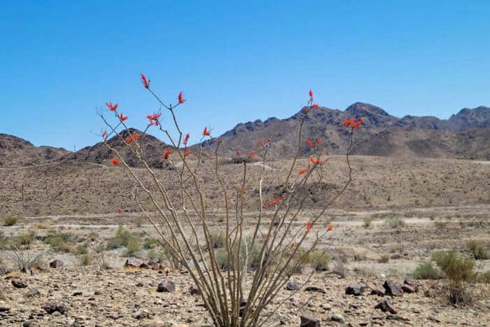
38 South West Section of Free Arizona Campsites
Jump directly to the 95 East Central Section of Arizona Boondocking Locations
Jump directly to the 68 West Central Section of Arizona Dispersed Campsites
Jump directly to the 48 South East Section of Arizona Booondocking Areas
1. Levee Road
Address
Ehrenberg, Arizona
GPS: 33.511639, -114.565392
Elevation: 265′
Management: Public – Bureau of Land Managment (Unofficial)
Numerous free, Arizona boondocking locations along the Colorado River. Some spots are on the east side of the road, others on the west. Busy on the weekends.The road in is Dirt and >5 miles from a paved road.
2. Road Runner BLM
Address
Highway 95 South
Quartzsite, Arizona
GPS: 33.585434, -114.220093
Elevation: 1063′
Management (Official)
The road in is Gravel and 0 miles from a paved road. Road Runner BLM is open year-round. There are 30 or more Free Arizona campsites at this location and the maximum RV length is any. You may stay 14 in 28 at Road Runner BLM.
3. Kofa – King Road
Address
Yuma, Arizona
GPS: 33.236859, -114.161381
Management: Public – Bureau of Land Management
Kofa Wildlife Management Refuge has many roads going in that have dispersed camping. The best sites, the most sites, and the more isolated sites can be found on King Road. The road in is Gravel. There are 30 or more Arizona booondocking areas at this location.
4. Crystal Hill Kofa
Address
Quartzsite, Arizona
GPS: 33.524468, -114.119072
Elevation: 1487′
Management: Public – Fish and Wildlife Service (Unofficial)
The road in is Dirt and 6mi miles from a paved road. There are 16-29 Arizona boondocking locations at this site and the maximum RV length is Any. You may stay 14days in 1yr at Crystal Hill Kofa.
5. Palm Canyon KoFA
Address
Palm Canyon Drive
Quartzsite, Arizona
GPS: 33.371105, -114.163918
Elevation: 1565′
Management: Public – Fish and Wildlife Service (Official)
The road in is Dirt and 5 miles from a paved road. Palm Canyon KoFA is open year-round. There are 6-15 Free Arizona campsites at this location and the maximum RV length is any. You may stay 14 nights at Palm Canyon KoFA.
6. Kofa Castle Dome
Address
Castle Dome Road
Yuma, Arizona
GPS: 33.036144, -114.181236
Elevation: 1288′
Management: Public – Fish and Wildlife Service (Official)
The road in is Dirt and 7 miles miles from a paved road. Kofa Castle Dome is open Year Round. The maximum RV length at Kofa Castle Dome is unlimited. You may stay 14 days in Arizona booondocking areas at Kofa Castle Dome.
7. Mittry Lake
Address
Yuma, Arizona
GPS: 32.819515, -114.480419
Management: Public – Bureau of Land Management (Unofficial)
Mittry Lake Wildlife Area lies in and adjacent to the floodplain of the Colorado River between Laguna and Imperial Dams. You may stay 10 days 1 year in Arizona boondocking locations at Mittry Lake.
8. Kool Corner
Address
Yuma, Arizona
GPS: 32.802849, -114.49424
Elevation: 182′
Management: Public – Bureau of Land Managment (Unofficial)
The road in is Dirt and 0.1 miles from a paved road. There are 6-15 Free Arizona campsites at this location and the maximum RV length is any.
9. Fortuna Pond
Address
Yuma, Arizona
GPS: 32.724342, -114.452873
Elevation: 156′
Management: Public – Bureau of Land Managment (Official)
The road in is Dirt and 3.2 miles miles from a paved road. Fortuna Pond is open Year round. There are 30 or more Arizona booondocking areas at this location and the maximum RV length is Any. You may stay 14 days at Fortuna Pond.
10. BLM near VFW
Address
7150 S Hwy 95
Yuma, Arizona
GPS: 32.729523, -114.423424
Elevation: 172′
Management: Public – Bureau of Land Managment (Official)
The road in is Dirt and <1 miles from a paved road. BLM near VFW is open Year round. There are 30 or more Arizona boondocking locations at this site and the maximum RV length is Any. You may stay 14 days at BLM near VFW.
11. Gravel Lot- Tacna, AZ
Address
near 39880 Old US 80, Tacna, AZ 85352
Wellton, Arizona
GPS: 32.69761, -113.95367
Elevation: 348′
Management: Private – Empty Lot (Unofficial)
The road in is Paved. Gravel Lot- Tacna, AZ is open year-round. There are 1-5 Free Arizona campsites at this location and the maximum RV length is unlimited. You may stay unknown at Gravel Lot- Tacna, AZ.
12. Saddle Mountain BLM
Address
Tonopah, Arizona
GPS: 33.458626, -113.055023
Elevation: 1250′
Management: Public – Bureau of Land Managment (Official)
The road in is Dirt and 1 miles from a paved road. You may stay 14 day standard BLM in Arizona booondocking areas at Saddle Mountain BLM.
13. Agua Caliente/Fourth of July Butte
Address
Agua Caliente Road
Dateland, Arizona
GPS: 33.279765, -112.995586
Elevation: 1012′
Management: Public – Bureau of Land Management (Unofficial)
The road in is Dirt and depends on how far into the area you go miles from a paved road. Agua Caliente/Fourth of July Butte is open year round although best in fall/winter/spring . The maximum RV length at Agua Caliente/Fourth of July Butte is unlimited. You may stay 14 days in Arizona boondocking locations at Agua Caliente/Fourth of July Butte.
14. Darby Wells Road – BLM
Address
Ajo, Arizona
GPS: 32.350246, -112.829964
Elevation: 1738′
Management: Public – Bureau of Land Managment (Official)
Darby Wells Road – BLM is open Year Round. There are 30 or more Free Arizona campsites at this location. You may stay 14 Days at Darby Wells Road – BLM.
15. Abandon Truckstop – Why, AZ
Address
Why, Arizona
GPS: 32.26464, -112.73955
Elevation: 1788′
Management: Private
Very large gravel area as well as large concrete pad under cover where the old pumps used to be. Arizona booondocking areas with convenience store and diner are directly across the street. Most suitable for RV’s for an overnight while passing through. The road in is Paved. The maximum RV length at Abandon Truckstop – Why, AZ is unlimited.
16. Gunsite Wash – BLM
Address
Why, Arizona
GPS: 32.238056, -112.751396
Elevation: 1798′
Management: Public – Bureau of Land Managment (Official)
Gunsite Wash – BLM is open Year Round. You may stay 14 Days in Arizona boondocking locations at Gunsite Wash – BLM. Dispersed camping near Why, AZ in the Sonoran Desert. Much of the surrounding Sonoran Desert area was closed by the BLM in 2003. Gunsite Wash is not included in the closures.
17. Ironwood Forest NM Dispersed
Address
Pipeline Road
Marana, Arizona
GPS: 32.45514, -111.45866
Elevation: 2280′
Management: Public – Bureau of Land Management (Official)
There are no developed campsites with facilities within the national monument. Visitors can pick their own campsite, but please camp at least 200 feet from water sources and use biodegradable soap. You may stay 14 days in Free Arizona campsites at Ironwood Forest NM Dispersed.
18. Ironwood Forest
Address
Marana, Arizona
GPS: 32.451147, -111.375582
Management: Public – Bureau of Land Management (Unofficial)
Just off a many times patched, paved road. Desert, but you can pitch a tent or park a rig. No facilities. Quiet at night, on national Forest I believe. The road in is Paved. There are 1-5 Arizona booondocking areas at this location.
19. Ironwood Forest National Monument
Address
Marana, Arizona
GPS: 32.44358, -111.37506
Elevation: 2005′
Management: Public – Bureau of Land Management (Unofficial)
Don’t let the name make you avoid it. This land is BLM so you can camp here. The road in is Dirt and 10 miles from a paved road. There are 6-15 Arizona boondocking locations at this site and the maximum RV length is 45 feet.
20. Buenos Aires National Wildlife Refuge
Address
Buenos Aires National Wildlife Refuge
Sasabe, Arizona
GPS: 31.637128, -111.448013
Elevation: 3416′
Management: Public – Fish and Wildlife Service (Official)
The road in is Dirt. Buenos Aires National wildlife refuge is open year round. There are 30 or more Free Arizona campsites at this location and the maximum RV length is unlimited. You may stay 14 days at Buenos Aires National wildlife refuge.
21. Hippy Hole Camp
Address
Cibola, Arizona
GPS: 33.37708, -114.70565
Elevation: 230′
Management: Public – Fish and Wildlife Service
Cibola Free River Camping Area. Large area with plenty of parking and a nice beach. Vault toilet on site. The road in is Paved. There are 16-29 Arizona booondocking areas at this location and the maximum RV length is unlimited.
22. Cibola
Address
South Cibola Lake Road
Cibola, Arizona
GPS: 33.363257, -114.662301
Elevation: 282′
Management: Public – Bureau of Land Management
Free Arizona boondocking locations in the Bureau of Land Management Yuma District. First come -> First Camped. Reservations not accepted.
23. Boondock and Target Shoot
Address
Ehrenberg, Arizona
GPS: 33.477098, -114.602598
Elevation: 259′
Management: Public – Bureau of Land Management (Unofficial)
Free Arizona campsites near Colorado River. Room for multiple RV’s and you’ll also have your very own shooting range 100 ft away.
24. BLM Old Yuma Road
Address
Quartzsite, Arizona
GPS: 33.552636, -114.22492
Elevation: 1112′
Management: Public – Bureau of Land Management (Official)
Free very large BLM Arizona booondocking areas 9 miles south of Quartzite,AZ on Hwy 95. Verizon hotspot worked well up to about 1/2 from highway. Very quiet,dark area that was flat and hard packed rock ground.
25. Kofa Queen Canyon
Address
Yuma, Arizona
GPS: 33.385278, -114.102466
Elevation: 2228′
Management: Public – Fish and Wildlife Service (Unofficial)
The best and easiest Arizona boondocking locations are on the hilltop just before the road enters Kofa Queen Canyon and becomes quite a bit more rugged.
26. Telegraph BLM
Address
Yuma, Arizona
GPS: 32.66702, -114.36828
Elevation: 446′
Management: Public – Bureau of Land Management (Official)
Free Arizona campsites in BLM dispersed camping area. Enter from Telegraph Pass N Lot and back to W on power line road about 1/2 mile. BLM area N of road 100 yds or so. Remote and quiet.
27. Foothills East BLM 14-day
Address
Yuma, Arizona
GPS: 32.63792, -114.35686
Elevation: 545′
Management: Public – Bureau of Land Management (Official)
Free BLM 14-day Arizona booondocking areas behind the Arizona State Lands. No Arizona State Lands permit required! Just follow any of the numerous roads past the State Land.
28. Cabeza Prieta NWR – Christmas Pass
Address
Unnamed Road
Ajo, Arizona
GPS: 32.277221, -113.694111
Elevation: 994′
Management: Public – Fish and Wildlife
Free Arizona boondocking locations. First come -> first camped. No reservations are accepted.
29. Cabeza Prieta NWR – Tule Well
Address
El Camino Del Diablo
Ajo, Arizona
GPS: 32.226391, -113.749748
Elevation: 1178′
Management: Public – Fish and Wildlife
Free Arizona campsites. This campsite does not use a reservation system. First come, first served.
30. Buenos Aires NWR
Address
Aguirre Lake Road
Sasabe, Arizona
GPS: 31.584502, -111.503513
Elevation: 3481′
Management: Public – Fish and Wildlife
Arizona booondocking areas. First come -> First Camped. Reservations not accepted.
31. Agua Caliente Road
Address
Agua Caliente Road
Arlington, Arizona
GPS: 33.254024, -112.889744
Elevation: 984′
Management: Public – Bureau of Land Management
Free Arizona boondocking locations located within the Bureau of Land Management Lower Sonoran District.
32. Cabeza Prieta NWR – Papago Well
Address
El Camino Del Diablo
Ajo, Arizona
GPS: 32.099108, -113.286984
Elevation: 912′
Management: Public – Fish and Wildlife
Free Arizona campsites. First come -> first served. No reservations accepted.
33. New Cornelia Mine Campsite
Address
Ajo, Arizona
GPS: 32.340847, -112.843688
Elevation: 1781′
Management: Public – Bureau of Land Management (Official)
Arizona booondocking areas have an existing concrete pad large enough to park 2 cars, plus a fire pit, and plenty of trees to hide your tent in.
34. Wild Woman
Address
Unnamed Road
Ajo, Arizona
GPS: 32.241257, -112.765267
Elevation: 1762′
Management: Public – Bureau of Land Management
Free Arizona boondocking locations in the Bureau of Land Management Lower Sonoran District. First come -> first camped. No reservations are accepted.
35. Old Ajo Highway Campground
Address
Tucson Estates, Arizona
GPS: 32.1614, -111.1038
Elevation: 2507′
Management: Public – Bureau of Land Management (Official)
There is LOTS of Free Arizona campsites, access is easy – we are almost 60′ long and were able to navigate in with ease, the land is level and the area is clean. We felt totally safe here and did not see any long term residents.
36. Mountain Road 684
Address
Amado, Arizona
GPS: 31.653048, -111.081249
Elevation: 3284′
Management: Public – Bureau of Land Management (Official)
Assorted Arizona booondocking areas along the gravel mountain road running through the high Sonoran Desert near Tubac, Arizona
37. Diablo Mountain – Coronado National Forest
Address
Amado, Arizona
GPS: 31.635432, -111.106454
Elevation: 3619′
Management: Public – Forest Service (Official)
Google maps will try to take you to a road with a locked gate. The actual turnoff is before that. Arizona boondocking locations.
38. Arivaca Lake
Address
FR 4130
Arivaca, Arizona
GPS: 31.526234, -111.25428
Elevation: 3817′
Management: Public – Forest Service (USDA) (Official)
Free Arizona campsites in Arivaca Lake is located in an area of rolling grasslands set against a backdrop of rocky bluffs and distant mountains. This area is home to a number of cattle ranches, and much of the land in the vicinity of the lake is private property. Take that into consideration if you go strolling across the landscape. Arivaca Lake is open Year-round.
You May Want to Join Our Boondocking Group on Facebook For More Information
You May Want to Join Our Campfire Recipes Group on Facebook For More Information
Check Out Our Pictures On Instagram – Our Big Escape.