

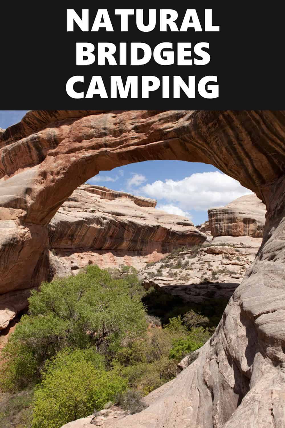
My husband and I decided to take a trip to the Natural Bridges National Monument in Utah, and it was quite the experience. It is amazing to see what water can do over the course of thousands of years, and how it managed to sculpt what is now this national park with three natural bridges and what seems to be never ending, beautiful landscape.
Whether you’re looking to take a break away from the fast-paced lifestyle, or you’re just someone who wants to be surrounded by natural scenery with a rich history, I highly recommend planning a trip to this park. Visit the Natural Bridges National Monument visitor center for more information.
Want more ideas to round-out your trip to Utah?
A lot of great ideas are in these posts!
- 24 Amazing Arches National Park Hiking Trails – Easy, Moderate, Hard
- 19 Great NE Utah Boondocking Spots With Maps
- 32 Free North-Central Utah Boondocking Areas Along With Maps
- 24 Top NW Utah Boondocking Locations Including Maps
- 51 Amazing East-Central Utah Boondocking Campsites And Maps
- 33 Best Central Utah Boondocking Sites Also Maps
- 21 Favorite West-Central Utah Boondocking Camp Sites Plus Maps
- 36 Free SE Utah Boondocking Camping Sites And Maps
- 43 Amazing South-Central Utah Boondocking Campgrounds With Maps
- 54 Top SW Utah Boondocking Camping Areas Including Maps
The Natural Bridges National Monument is a place that has been inhabited and abandoned by people time and time through history, and the people who lived there definitely left their marks on the territory. Traces of tools and rocks indicate that people first began using the area during what is known as the Archaic Era (as far back as 7000 BC).
200 years after this group left, around 700 CE, the ancestors of the Puebloan people lived along the Mesa tops and left when they saw changes occur in the environment of the area. Puebloan farmers returned a few hundred years later and built the homes out of sandstone and mud that you can see the ruins of today.
Other artifacts that were discovered in the area indicate that the land was also inhabited by people from the Mesa Verde region, the Kayenta region, the Fremont culture, the Navajos and Paiutes tribes, and more. The Natural Bridges National Monument now stands as a remarkable place to preserve and honor the history of people who lived on this land.
16 Free Natural Bridges National Monument Boondocking Locations
check out our video
1. Natural Bridges National Monument Boondocking – Human Panted Rocks in Burch Canyon
Address
Lake Powell, Utah
GPS: 37.610409, -109.929119
Elevation: 6811′
Management: Bureau of Land Management
The road in is Dirt and 6 miles from a paved road. There are 1-5 campsites at this location. Cool little prepared spot on public lands great for tent camping (and you can pull your RV in Nearby)
Best Review:
My friend and I car camped here for just one night on our way in to Natural Bridges National Monument. It was a great spot! The road in was just over a mile and we had no problems in our minivan. Found a nice flat spot to park and sleep. Noticed a few fire pits around the location but didn’t use them. It’s nice and quiet and away from the road but I imagine in the summer it might get more crowded.

2. Natural Bridges National Monument Boondocking Locations – Burch Canyon Road
Address
Road 254
Utah
GPS: 37.601438, -109.923472
Elevation: 6998′
Management: Bureau of Land Management
You may stay 14 days at Burch Canyon Road. About 3 miles outside of Natural Bridges National Monument UT, look for a sign for Deer Flat Rd. Turn onto that road. Smaller sites on the left in the trees just as you turn into the road (Burch Canyon) and a larger site (large turnaround area) about a half mile up the road.
Best Review:
We found a cozy nook for ourselves among the PJ forest and red soil. Easy access to Natural Bridges! Not busy at all when we were there in late October.
3. Natural Bridges National Monument Camping Spots – Grand Gulch
Address
Utah 95
Blanding, Utah
GPS: 37.582931, -109.893541
Elevation: 6772′
Management: Bureau of Land Management
The road in is 4×4. Free Dispersed camping in the Bureau of Land Management Monticello District. No reservations. First come, first served. It is recommended that you have 4×4 and high clearance to reach this free camping area.
Best Review:
None
4. Natural Bridges National Monument RV Parking – Jct 95 – 261
Address
Unnamed Road
Blanding, Utah
GPS: 37.570671, -109.882549
Elevation: 6801′
Management: Bureau of Land Management
Free Dispersed camping in the Bureau of Land Management Monticello District. No reservations. First come, first served.
Best Review:
About a half mile off of the paved road. Downhill going in, not bad. I made it fine with my jeep liberty and homemade utility trailer camper. comes out a a large flat area covered in pea gravel. Plenty of room.
5. Natural Bridges National Monument Hiking – Salvation Knoll
Address
Blanding, Utah
GPS: 37.561635, -109.813721
Elevation: 7021′
Management: Bureau of Land Management
The road in is Dirt and 1 miles from a paved road. There are 6-15 campsites at this location and the maximum RV length is 35 feet.
Best Review:
This campsite is just east of Salvation Knoll on the south side of highway 95. This is about 4 miles east of highway 261. Lots of campsites along the road starting close to highway 95 and then much further in. Will accommodate everything from tents, campers, and RVs.
6. Natural Bridges National Monument Boondocking – Manti-Salal National Forest
Address
Utah
GPS: 37.5859, -109.785
Elevation: 6936′
Management: National Forest Service
You may stay 14 days at Manti-Salal National Forest. Lots of sites throughout the park, easily visible from road. This particular location shows several sites with fire rings overlooking the canyon. Very scenic.
Best Review:
None
7. Natural Bridges National Monument Boondocking Locations – County Road 236 Boondock
Address
Blanding, Utah
GPS: 37.524635, -109.748459
Elevation: 6100′
Management: Bureau of Land Management
The road in is Dirt and 1.5 miles from a paved road. There are 1-5 campsites at this location and the maximum RV length is 30. You may stay 14 days at County Road 236 Boondock.
Best Review:
Great spot, much better than Arch Canyon about 10 minutes east on the 95. As Arch Canyon is in a wash between two ridges, there is little to no mobile connectivity, but I was able to maintain connectivity at my site (which is nice for emergency concerns). If heading west on the 95, turn left about 1-3 minutes after passing the Mule Canyon Ruins site (this location is a paved road/parking lot and has pit toilets if necessary). The dirt road is actually road 236, there is not a sign for “236” when leaving the 95 but you can see the sign along the dirt road when turning onto it. There will be 4-5 spots within the first mile.
8. Natural Bridges National Monument Camping Spots – Hammond Canyon Overlook
Address
Utah
GPS: 37.681236, -109.767778
Elevation: 8058′
Management: National Forest Service
The road in is Dirt and 15 miles from a paved road. Hammond Canyon Overlook is open April to early December. There are 6-15 campsites at this location and the maximum RV length is 15 feet. Elk Ridge Road itself is a good quality gravel road.
Best Review:
One of the highest elevation camps in the area at 8000 feet with ok+ plus views of Hammond Canyon. One large site with easy access near corrals, several along Canyon rim with high clearance access. As I recall this was at the limit of 3g smartphone access. You can see the worst of the road from the corrals and there are plenty of alternatives in the area. Elk Ridge Road itself is a good quality gravel road.
9. Natural Bridges National Monument RV Parking – Edge of the Beyond
Address
Blanding, Utah
GPS: 37.560255, -109.658227
Elevation: 5745′
Management: Bureau of Land Management
The road in is Dirt and -10 miles from a paved road. Edge of the Beyond is open All Year. There are 6-15 campsites at this location and the maximum RV length is 35 feet. You may stay 14 days at Edge of the Beyond. Choice cliff edge spots on the crest of the northern portion of the iconic Comb Ridge. Hiking with ruins in upper Butler Wash.
Best Review:
Absolutely beautiful and secluded. Not too far off of UT 95 and about a 30 minute drive from the campsite to Blanding. You take Elk Mountain Rd (partly paved to gravel road) turn right, go about 1/4 mile to Posey Trail, turn left. The you will go about 3 miles to the campsite marked by the coordinates list at top of this campsite listing. Posey Trail is OK for the most part. It’s dirt and some rough rocky areas. The roughest part of this road is just before you get to the campsite.
10. Natural Bridges National Monument Hiking – Arch Canyon
Address
Comb Wash Rd.
Blanding, Utah
GPS: 37.50959, -109.654022
Elevation: 4840′
Management: Bureau of Land Management
Arch Canyon has Pit Toilets. Access through Comb Wash, 2 miles from UT-95.
Best Review:
This place was excellent to us. Stayed for 5 nights for day trips to Natural Bridges, Cedar Mesa (we recommend Kane Gulch hike), and Valley of the God’s. We had a drop toilet all to ourselves and nice views of Comb Ridge every morning and night. No cell service or LTE, but spotty connection could be found on the high points of the road towards Natural Bridges. Road was sandy and could be a problem if wet.
11. Natural Bridges National Monument Hiking – Fry Mesa
Address
Lake Powell, Utah
GPS: 37.622705, -110.083528
Elevation: 5843′
Management: Bureau of Land Management
The road in is Dirt and .2 miles from a paved road. There are 1-5 campsites at this location. Just off the 95 down a short dirt road, there were a few fire rings set up.
Best Review:
None
12 Free Natural Bridges National Monument Boondocking Locations – Jacob’s Chair
Address
Utah 95
Lake Powell, Utah
GPS: 37.706954, -110.23939
Elevation: 4849′
Management: Bureau of Land Management
Free Dispersed camping in the Bureau of Land Management Monticello District. First come -> First Camped. Reservations not accepted.
Best Review:
I was parked on the rim of the canyon with great views in all directions! I had the site to myself most of the time with the occasional motorcycle or jeep going up the trail to Jacobs Chair.
13. Natural Bridges National Monument Boondocking – Blue Notch Road BLM Boondock
Address
Hanksville, Utah
GPS: 37.763397, -110.293869
Elevation: 4823′
Management: Bureau of Land Management
The road in is Dirt and .5 miles from a paved road. There are 1-5 campsites at this location and the maximum RV length is 40+. You may stay 14 days at Blue Notch Road BLM Boondock.
Best Review:
It’s a 4 wheel drive road that leads to the lake but the first half mile is in good condition and can be driven by any vehicle. The camping spot is 1/2 mile in on the left hand side in a cleared area with a stone fire ring.
14. Natural Bridges National Monument Boondocking Locations – White Canyon Overlook
Address
Lake Powell, Utah
GPS: 37.798324, -110.304595
Elevation: 4610′
Management: Bureau of Land Management
West of Natural Bridges National Monument on Hwy 95, just a large pullover site at MP 62.5, but beautiful views of the canyon and not much traffic on Hwy 95 so pretty quiet. There is another larger area about 5 miles east of here as well – both on the canyon side of the road.
Best Review:
None
15. Natural Bridges National Monument Camping Spots – Muley Point Overlook
Address
Muley Point Road
Bluff, Utah
GPS: 37.235187, -109.992233
Elevation: 6343′
Management: National Park Service
The road in is Dirt. The maximum RV length at Muley Point Overlook is 15 feet. This is a dispersed campsite and not a campground. No facilities (toilets, water, trash) provided. If that’s your kind of thing, prepare to be amazed! The views here are stunning. On a good day, you can see Monument Valley, the Four Corners, Valley of the Gods, and the Goosenecks.
Best Review:
Couldn’t have asked for a better FREE place to lay your head. The views are insane! If you can deal with the wind (tent campers beware, bring stuff sacks to use as anchors and fill with rocks!) there are plenty of spots along the edge to set up your tent or rig. We came in later in the afternoon the week before Memorial Day and still had plenty of room. Aside for the jacka$$ passing our SUV on the Moki Dugway at 50mph, the road up was a piece of cake for our Hyundai Santa Fe. Waking up to a view like this is an opportunity you do not want to miss.
16. Natural Bridges National Monument RV Parking – Valley Of The Gods, Bluff & Mexican Hat, Utah
Address
Valley Of The Gods Road
Bluff, Utah
GPS: 37.316864, -109.850533
Elevation: 5034′
Management: Bureau of Land Management
Website The Valley Of The Gods is a personal favorite. It is called “the little Monument Valley”, and it is, but with very few visitors in contrast to the big valley to the south. This is desert boondocking at it best! It is a great boondocking site for an overnight between Monument Valley/Grand Canyon/ Canyon Lands/Arches Nat’l Parks.
Best Review:
This is one of my favorite boondocking campsites of all time. In late September, I stayed at the foot of a giant butte near the turn in the road at its northeastern-most point – about halfway in from either highway. A few cars came through during the day, but it was deathly quiet all night. The road in from the west off highway 261 was fun with no less than 20 dry washes to cross. Big rigs will have trouble with that route as the road drops steeply into the gullies and then climbs steeply back up the other side
Top 10 Trails to Hike at Natural Bridges National Monument
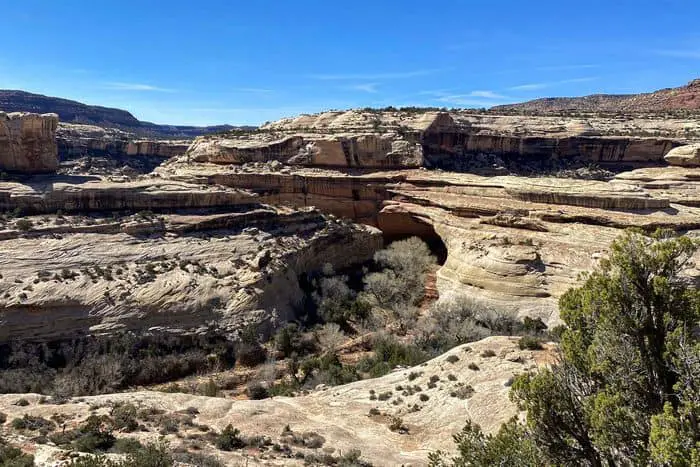
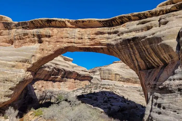
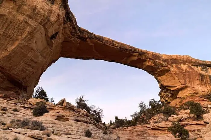
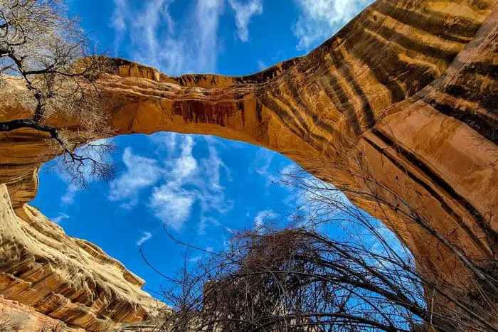
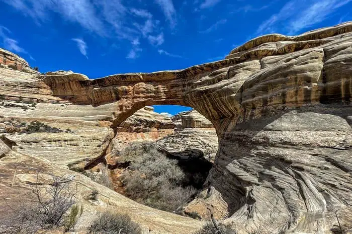
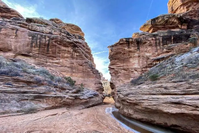
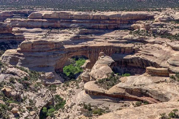
Natural Bridges National Monument (6,200-ft), situated high atop Cedar Mesa, illustrates the power of water in shaping a high desert landscape. Intermittent streams have cut two deep canyons and three massive bridges in sandstone formed from what was once the shore of an ancient sea that covered the area.
Trails, starting on the mesa, descend into the canyons to the bridges, named “Kachina,” “Owachomo” and “Sipapu” in honor of the Native Americans that once lived in the area.
Natural Bridges National Monument Hiking #1. Sipapu Bridge
This trail was a little challenging, yet still an incredible hiking experience for us. The combination of ladders, railings, and steps helped with the climb quite a bit, especially with the possibility of having to walk through water. It was a gorgeous trail with at least a dozen different wildflower species to get a glimpse at. No matter which side of the trail you choose to hike, it seems both sides pose a challenge of their own.
If you don’t pay close attention while in route, you may overlook the Horsecollar ruin; we almost walked right past it. Overall, the experience was thrilling, and I would love to be able to visit again when it’s a little drier and easier to walk through. If you can handle the trail, it is a “must hike” when visiting the Natural Bridges National Monument.
Length: 5.8 mi
Elevation gain: 990 ft
Route type: Loop
Natural Bridges National Monument Camping, Hiking, Walking, River, Views, Wildlife, Rocky, Fee, No dogs
Natural Bridges National Monument Hiking #2. Sipapu Bridge to Kachina Bridge Loop
This hiking trail was fantastic! The path is very well maintained, and the hike was only moderately challenging. There are two steel ladders along the hike, but aside from those two there were stairs and handrails to assist along the way of the trail. It did rain before we began our hike, so the canyon was muddy during our walkthrough, and some of the trail was washed away, but the presence of running water in the area made everything that much more beautiful.
This may be one of the best hikes I’ve ever been on, and I plan to return to the National Bridges National Monument to hike it again. Perhaps in a different season so that I can see the trail in a different element.
Length: 5.8 mi
Elevation gain: 990 ft
Route type: Loop
Natural Bridges National Monument Camping, Hiking, Walking, River, Views, Wildlife, Rocky, Fee, No dogs
Natural Bridges National Monument Hiking #3. Owachomo Bridge Trail
This bridge was the easiest of all to access and the trail was fairly short. We hiked this trail on the last day of our stay and enjoyed the descent down, as well as the view from under the bridge itself. It seems to be a popular spot in the evening for pictures of the Milky Way galaxy and we actually saw a few photographers preparing to take some shots of the views. Worth the hike.
Length: 0.7 mi
Elevation gain: 216 ft
Route type: Out & back
Kid friendly, Hiking, Walking, Bird watching, Views, Wildflowers, Wildlife, Rocky, Snow, Fee, No dogs
Natural Bridges National Monument Hiking #4. Under the Natural Bridges Loop
First off, this was a spectacular trail to hike. However, secondly, I find it hard to believe that this trail was only 8.2 miles. According to my tracker, the trail is at least 9 miles in distance. Spikes come in handy during the initial descent into the trial, but they aren’t really needed after that. By the time you reach the steep part, there are handrails leading you to the second ladder, and you’re fine to hike the rest of the way.
The trail was marked well despite not necessarily being maintained. It took us six hours to complete the trail, and I would not recommend going in the summer. Thankfully, we went during spring, and the weather was perfect. My only warning is if it rains, the rocks may be a little slick, so be careful! Nevertheless, it was a fantastic hike and if you feel up to the challenge, you should give it a try.
Length: 8.2 mi
Elevation gain: 994 ft
Route type: Loop
Hiking, Views, Wildflowers, Wildlife, Rocky, No shade, Fee, No dogs
Natural Bridges National Monument Hiking #5. Kachina Bridge Trail
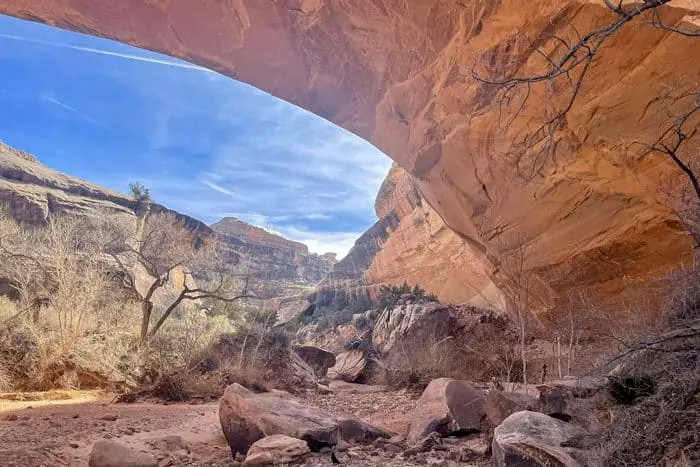
For this hike, we had the option of seeing the bridge from the overlook or descending into the canyon to see it from underneath. The trail has a fork in it. The right path takes you to the overlook, which is flat, and it looks paved over with concrete. The left path is the one that takes you down into the canyon. It starts out with some pretty steep steps, and as your make your way around a huge boulder that appears to be shaped like a mushroom, the path will start to level out.
This boulder in particular is the one you stand on for the overlook. The trail then turns back into a steep decline, which we decided not to go any further down due to how slippery and wet the area was. As we made our way back up the trail, we tried to get as many great pictures as we could from the more leveled area. I would love to go back when it’s not so wet to get the full experience.
Length: 1.3 mi
Elevation gain: 406 ft
Route type: Out & back
Hiking, Walking, Bird watching, Views, Wildflowers, Wildlife, Rocky, Fee, No dogs
Natural Bridges National Monument Hiking #6. Horsecollar Ruin Trial
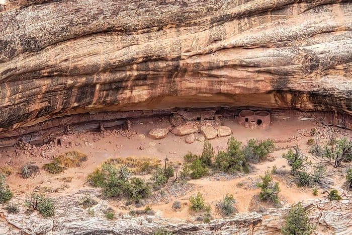
There wasn’t much that was special about the trail itself. The hiking path was relatively flat, until you started to get to the viewpoint. It’s a little rocky and there is a small descent, but there is railing, and the view at the end is what made it special. This path leads to a viewpoint of the Pueblo Ruins, and what we saw was worth every step!
Length: 0.6 mi
Elevation gain: 55 ft
Route type: Out & back
Kid friendly, Hiking, Walking, Views, Historic site, Fee, No dogs
Natural Bridges National Monument Hiking #7. Kachina Bridge Overlook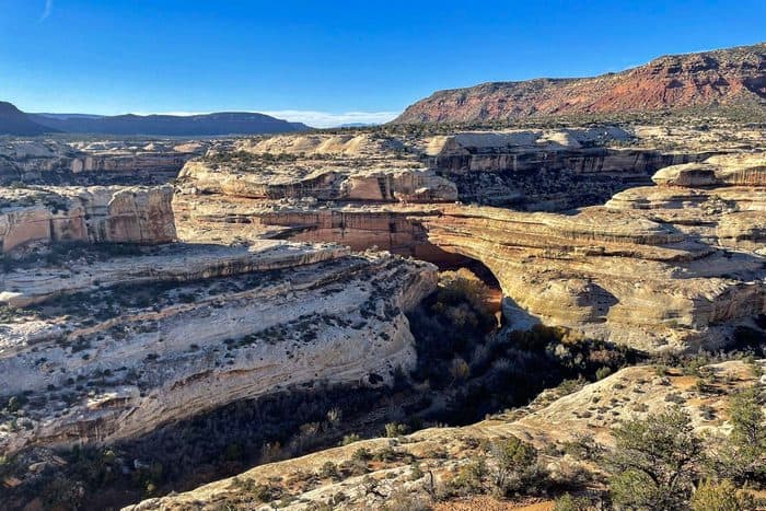
We came here after hiking through the White Canyon from the Sipapu Bridge. It is a nice flat area that is easily accessible, and it has a great overlook of the surrounding landscapes and distant bridge. It’s perfect for those with limited time or limited abilities. However, if you are able to, I insist you hike through the area and experience it up close.
Length: 0.3 mi
Elevation gain: 42 ft
Route type: Out & back
Wheelchair friendly, Kid friendly, Stroller friendly, Walking, Paved, Views, Wildflowers, Wildlife, No shade, Fee
Natural Bridges National Monument Hiking #8. Natural Bridges National Monument Drive
This is the nine-mile one way loop that is considered the main road, and it is most commonly driven, so my husband and I decided to spend a day driving it. It is $20 per car, but the drive was definitely worth it! The area is remote, and the crowds are smaller.
The main road does have pull-off as mentioned earlier, and the park ranger that we met suggested that we stop at every pull-off that had a rock with a name on it, so we did. If you’re going to visit, I highly recommend that you take the time to do the same! Being that this is a one-way road, if you decide to pass a pull-off, you cannot turn around to go back to it.
Length: 9.0 mi
Elevation gain: 761 ft
Route type: Loop
Scenic driving, Views, Fee
Natural Bridges National Monument Hiking #9. Collins Spring to The Narrows
Technically this trail is not within the boundaries of the Natural Bridges National Monument. However, it was still a great hike, even in the midst of the rainy season. The trail seems to be a little difficult to find at times, but we managed. There are some beautiful views of the canyons on this path. There’s also a river that flows along the path that contributes to the beauty of the hike, and it’s easy enough for someone new to hiking to enjoy.
Length: 3.9 mi
Elevation gain: 544 ft
Route type: Out & back
Kid friendly, Hiking, Walking, Bird watching, Running, River, Views, Wildflowers, Wildlife, Fee, No dogs
Natural Bridges National Monument Hiking #10. Sipapu Bridge Viewpoint
Well, I’m not sure if I would call this a hike. It was a very short walk, but I will say that it leads to a beautiful view of the Sipapu Bridge. It is the second largest natural bridge in the world, and the rock coloring is quite unique.
Length: 0.1 mi
Elevation gain: 3 ft
Route type: Out & back
Walking, Views, Fee
Places and Things to Do and See with Descriptions in Natural Bridges National Monument
Hiking/Auto-Touring
Of course, the most obvious and natural thing to do while visiting the Natural Bridges National Monument would be to hike a trail, or two or three. There are several trails and viewpoints to walk through along the nine-mile loop that is the park’s main road, which counts as a trail worth experiencing itself.
Some people also like to do what is called auto-touring when it comes to this road, which is driving and sightseeing, as opposed to hiking through the area. The main road is a nine-mile long, one way route that consists of pull-offs for you to stop and sight-see or walk around.
It was recommended to us to drive through every pull-off that we encounter along the way because it is a one-way road, so you cannot go back to any that you pass along the route without going back to the start point.
Bird Watching
I’m not sure if the Natural Bridges National Monument is known for its variety of bird species, but there are over 200 different birds that live in or travel through the monument. If you keep your eyes peeled, you may be able to find some lesser seen birds resting in the area. To my surprise, we actually managed to spot a little duck resting in a pool of water, on the canyon floor.
Later on, we learned it was likely a green-winged teal, and that they are sometimes found in the ephemeral pools that rest at the bottom of the canyon. If you want to know what other birds to watch for at the Natural Bridges National Monument, they have books and other materials available for purchase in the visitor center bookstore.
Camping
There are campgrounds at the Natural Bridges National Monument for those who enjoy nature enough to sleep outdoors overnight. Each campsite is surrounded by juniper trees to create a sense of solitude, and they’re equipped with a picnic table, fire grill, and tent pad. There is no running water, and it is illegal to gather wood while you’re there, so be sure to bring your own water and firewood.
You are also allowed to bring a trailer, which was the option my husband and I chose on our trip to the monument. Nevertheless, we made sure to get a view of the beautiful sky each evening, which is probably the best reason for spending the night in the Natural Bridges National Monument.
Natural Bridges National Monument Stargazing
With the Natural Bridges National Monument having virtually no light pollution, it’s the perfect place to go and star gaze at night. In fact, you can see the Milky Way light up the night sky, and it’s a clear difference from what you might see at night when you look up in an urban area. Natural Bridges is officially recognized as an International Dark Sky Park, meaning there is a goal in place to preserve the sky and keep people educated about light pollution and ways to reduce their contribution to it.
All in all, our trip to the Natural Bridges National Monument was one to remember. We got to learn a bit of history, see the Milky Way, and witness the beauty and power of water in the formation of the bridges, the canyon, and the ruins. The only thing I would do differently is go during a season where the chance of rain is not so high, so that we don’t have to be so cautious of the slippery paths. However, the rainy season provided it own sense of beauty to the area.
If you ever need a sight to see, visit the Natural Bridges National Monument!
You May Want to Join Our Boondocking Group on Facebook For More Information
You May Want to Join Our Campfire Recipes Group on Facebook For More Information