

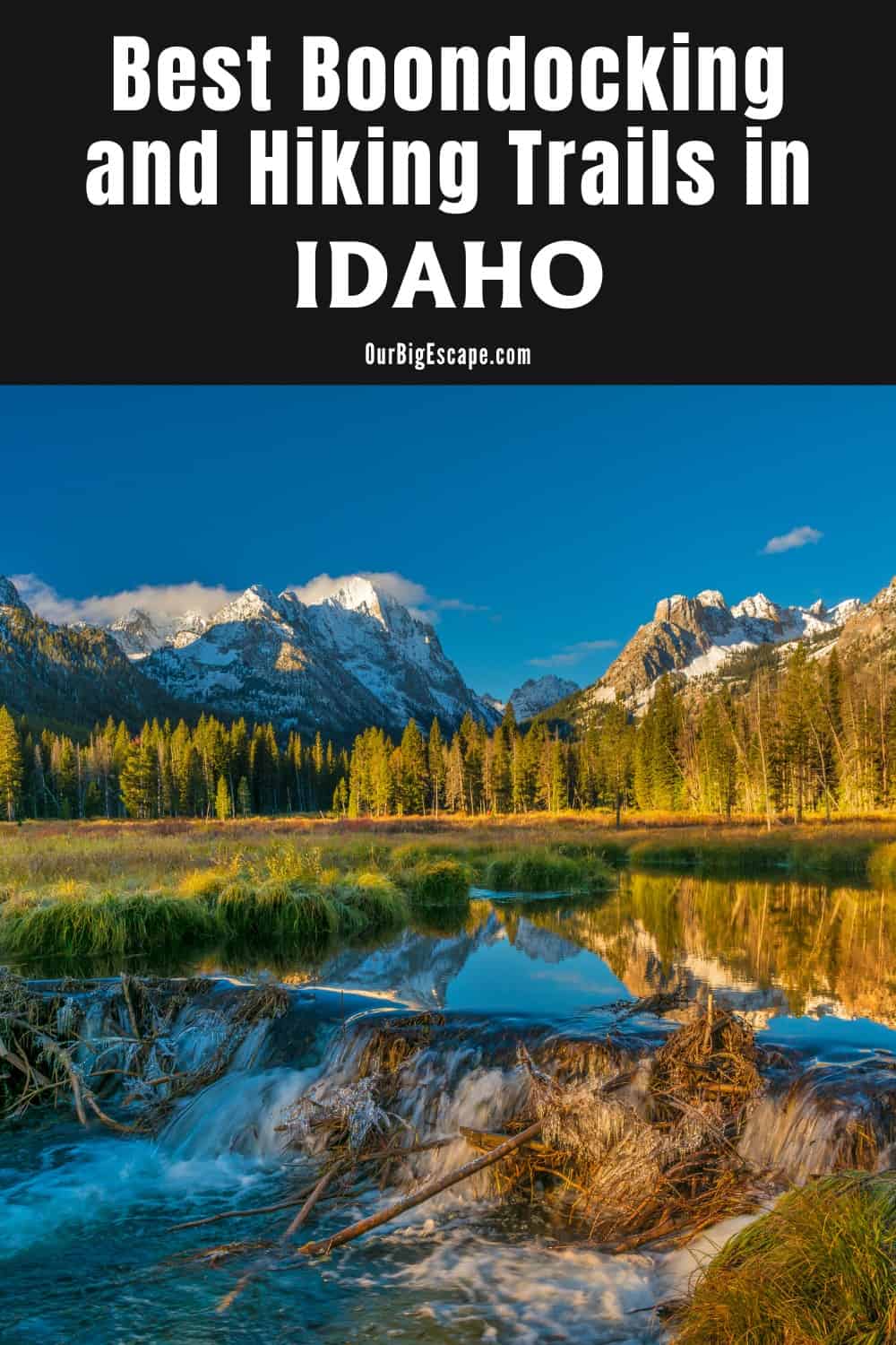
Choosing Free Idaho boondocking locations is the finest way to experience the state’s natural beauties, from lakeside places to campsites beneath jagged mountain peaks. Idaho boasts numerous of campgrounds. Idaho RV parking areas and basic camping away from the people. There are plenty of beautiful sites to pitch a tent or park an RV in Idaho.
| These Boondocking & Camping Areas are concentrated in the South-East part of IDAHO |
Free Idaho Boondocking Locations
Idaho free camping sites in several national forests is always a great way to go. These wooded areas are punctuated by designated campgrounds run by the US Forest Service. Vault toilets, potable water, and certain advance reservations are provided at Forest Service campgrounds.
In the national forests, Idaho hiking and dispersed camping is also popular. Camping in the national forest outside of permitted campgrounds is known as dispersed camping or primitive camping. Dispersed camping is typically found on pull-offs off unpaved Forest Service roads. Although dispersed camping is free, it lacks services such as potable water and garbage pickup. Anything brought into the woods by dispersed campers must be packed out.
The state parks also have wonderful free Idaho boondocking campgrounds. More amenities, such as flushing toilets and showers, are available at these campgrounds. Massive sand dunes, 1,000-foot-deep lakes, and numerous wildlife sightings are just a few of the state park adventures. Many state park campsites can be reserved up to six months in advance.
Want more ideas to round-out your trip to the North-Western States?
► Idaho, Montana, Oregon, Washington, Wyoming ◄
- 66 Free Central Idaho Boondocking – RV Parking & Camping Spots
- 78 Free Northern Idaho Boondocking – Camping & RV Parking
- 60 Free SE Idaho Boondocking – RV Parking & Camping Sites
- 40 Free SW Idaho Boondocking – RV Parking & Camping
- 198 Amazing Montana Boondocking Sites Including Maps
- 54 Free NE Oregon Boondocking Locations With Maps – North East Section
- 104 Free Boondocking Spots in NW Oregon With Maps – North West Section
- 308 Awesome Washington Boondocking Spaces With Maps
- 38 Free Boondocking Locations in Wyoming With Maps – North East Section
- 49 Free Wyoming Boondocking Campsites With Maps – North West Section
- 44 Free Boondocking Campsites In Wyoming With Maps – South East Section
- 66 Free Boondocking Spots in Wyoming With Maps – South West Section
60 Top SE Idaho Boondocking Locations
check out our video
1. Craters of the Moon Sagebrush Site
Address
Moore, Idaho
GPS: 43.42227, -113.63264
Elevation: 5791′
Management: Public – Forest Service (Unofficial)
The road in is Dirt and .9 miles from a paved road. There are 1-5 Idaho boondocking locations in this location. The campground at Craters of the Moon National Monument was full, so I had to improvise. As it turns out, I would be grateful because what I found was remarkable. This dispersed site is about eleven minutes away from the official Lava Flow campground and monument entrance. The turn-off is about 5.2 miles (or six minutes) south of the visitor center.
2. Honeys Park
Address
2436 N 3000 W
Butte City, Idaho
GPS: 43.628648, -113.296123
Elevation: 5315′
Management: Private – Privately Owned Campground (Official)
There are 30 or more Idaho free camping sites in this location. Fire pit, propane grill and shared beer fridge. A spare camper for guest use with heated shower and laundry facilities on board. I’m still a free dry campground but except for water and my budget I’ve got it a fair campground lately.
3. Turn Out Off The 33
Address
Howe, Idaho
GPS: 43.803869, -112.848507
Elevation: 4892′
Management: Public – Rest Area (Unofficial)
Idaho boondocking locations in large concrete turnout gets hot 60 feet away from the highway. The highway is lightly trafficked, super quiet. I car camp and slept like a baby. There is some beautiful rolling hills scenery to wake up to. Great for an overnight spot without trekking into the NF. Large RVs and trailers would fit easily.
4. Birch Creek – South Mud Lake
Address
Terreton, Idaho
GPS: 43.872, -112.4091
Elevation: 4790′
Management: Public – Fish and Wildlife Service (Official)
Idaho free camping sites in Birch Creek – South Mud Lake is open year round. You may stay 14days at Birch Creek – South Mud Lake. The road in is Gravel and about 3 miles from a paved road. There is only 1 campsite at this location. No water, or any hookups. It also has access to boat ramp. Managed by the Idaho Department of Fish and Game.
5. Hell’s Half Acre
Address
Blackfoot, Idaho
GPS: 43.554584, -112.440822
Elevation: 5135′
Management: Public – Bureau of Land Management
Amazing location for rock hounds and cavers. Idaho boondocking locations.
6. Elephant Hunters Historical Marker
Address
Idaho Falls, Idaho
GPS: 43.542825, -112.353745
Elevation: 5079′
Management: Public – Bureau of Land Management: (Official)
Idaho free camping sites about 13 miles west of Idaho Falls, on Hwy. 20. A bonus: there’s a lava cave here! You can go in about 1-1/2 miles (it use to go 17 miles, but collapsed at one point). Good spot for an overnighter. Hwy traffic is minimal, until 6 am, when workers go to Idaho Laboratories site. I didn’t know there was a cave here until a car showed up, and a few people put on coats and disappeared. There is a constant flow of very cool air blowing out the entrance…a good place to cool off!
7. McTucker Ponds
Address
Pingree, ID
Springfield, Idaho
GPS: 43.038633, -112.653832
Elevation: 4360′
Management: Public – Fish and Wildlife Service (Official)
The road in is Gravel and 1.5 miles from a paved road. McTucker Ponds is open All year. There are 6-15 Idaho boondocking locations in this location and the maximum RV length is 45 feet. A cluster of 8 ponds and a creek surrounded by willows and a few large cottonwood trees. There are many places for kids to fish from docks or the bank. Campsites are undeveloped, but most are around the ponds.
8. Snake River Vista Access
Address
Unnamed Road
American Falls, Idaho
GPS: 42.742171, -112.920903
Elevation: 4259′
Management: Public – State Park
Free Idaho free camping sites. First come ->first served. No reservations accepted.
9. Pipeline Campground
Address
Pipeline Road
American Falls, Idaho
GPS: 42.74082, -112.89997
Elevation: 4285′
Management: Public – Bureau of Land Management: (Official)
There are 6-15 Idaho boondocking locations in this location. You may stay 14 in 28 days at Pipeline Campground. 8 primitive campsites with some picnic tables, fire rings, vaulted toilet, horse shoe pits, and a parking lot. There are also boat ramps/boat docks available for accessing the Snake River below American Falls Reservoir Dam at the site. Pets must be on leash at all times, 14 day camping limit within a 28 day period.
10. Eagle Rock Access
Address
3374-3400 Neeley Road
American Falls, Idaho
GPS: 42.708459, -112.937603
Elevation: 4327′
Management: Public – State Park
Idaho free camping sites with the snake river near by. Did not stay the night but chilled in a “campsite” along the dirt road. After turning off eagle rock road it turns to a dirt road that is not maintained and full of ruts. Remember to pack out all trash as to not leave it filthy for the next travelers. There were some sites littered with broken glass and trash.
11. McClendon Spring Campground
Address
Malta, Idaho
GPS: 42.33558, -113.40717
Elevation: 4839′
Management: Public – Bureau of Land Management: (Official)
The road in is Dirt and 4 miles from a paved road. There are 1-5 Idaho boondocking locations in this location and the maximum RV length is 35 feet. Primitive campground. Undeveloped exploration of the Cottrel Mountains. Hunting for upland birds and antelope.
12. East Fork Rock Creek
Address
East Fork Road
Rockland, Idaho
GPS: 42.558216, -112.775371
Elevation: 5157′
Management: Public – State Park
Free Idaho free camping sites. First come -> first camped. No reservations are accepted. It’s a nice area close to home. It fills up fast on weekends.the roads could use better maintenance. When it rains hard and many days in a row roads wash out and then your stuck.maybe roads could be grated and gravel put down or something.
13. Blackrock Canyon OHV
Address
Black Canyon Road
Pocatello, Idaho
GPS: 42.814374, -112.330469
Elevation: 4748′
Management: Public – Bureau of Land Management: (Official)
Idaho boondocking locations in Blackrock Canyon OHV is open Nov 16-April 14. You may stay 14 days at Blackrock Canyon OHV. Blackrock canyon is open from April 15th to Nov. 15th for camping in designated areas. The BLM does not want people camping along the road pullouts between Nov. and April.
14. East Fork Mink Creek
Address
Pocatello, Idaho
GPS: 42.720064, -112.375945
Elevation: 5390′
Management: Public – Forest Service (Unofficial)
Free Idaho free camping sites. – turnout along a secondary forest road.
15. Indian Rocks Dispersed Camping
Address
McCammon, Idaho
GPS: 42.66924, -112.2167
Elevation: 4718′
Management: Public – Bureau of Land Management: (Unofficial)
The road in is Gravel and 1 mile miles from a paved road. There are 6-15 Idaho boondocking locations in this location and the maximum RV length is unlimited. You may stay 14 days at Indian Rocks Dispersed Camping. This is the site of a Idaho state park that no longer exists. All that’s left are the stone pilars at the entrance road. It’s not an ideal campsite because it’s so close to the interstate but it’s good for a night or two and much better than the Flying J parking lot if you don’t want to drive far off of your route.
16. Goodenough Creek Campground
Address
Green Road
McCammon, Idaho
GPS: 42.65528, -112.28533
Elevation: 5589′
Management: Public – Bureau of Land Management: (Official)
There are 6-15 Idaho free camping sites in this location. You may stay 14 in 28 days at Goodenough Creek Campground. 13 primitive campsites with some picnic tables, fire rings, and a vaulted toilet. There is also a day-use picnic area with horse shoe rings, kids sand box, picnic tables and barbeque grills. There are motorized and non-motorized trails leading to the Caribou – Targhee National Forest trail system.
17. East Fork Rock Creek
Address
East Fork Road
Rockland, Idaho
GPS: 42.558216, -112.775371
Elevation: 5157′
Management: Public – State Park
Free Idaho boondocking locations. First come -> first camped. No reservations are accepted. It’s a nice area close to home. It fills up fast on weekends.the roads could use better maintenance. When it rains hard and many days in a row roads wash out and then your stuck.maybe roads could be grated and gravel put down or something.
18. Hawkins Reservoir Campground
Address
South Hawkins Road
Arimo, Idaho
GPS: 42.512012, -112.331478
Elevation: 5149′
Management: Public – Bureau of Land Management: (Official)
There are 6-15 Idaho free camping sites in this location. You may stay 14 in 28 days at Hawkins Reservoir Campground. Developed campground with 10 primitive campsites. shelters, picnic tables, 2 vault toilets. Boat ramp/docks and fishing.
19. Cherry Creek
Address
South Cherry Creek Road
Malad City, Idaho
GPS: 42.304607, -112.135805
Elevation: 5817′
Management: Public – Forest Service
Free Idaho boondocking locations located within the Caribou-Targhee National Forest’s Westside Ranger District. Most helpful review
Three possible campsites. One with a pen that could probably hold horses. One that is just a flat area with river access and some rock circles. A third that is closest to the trail head and has picnic tables, fire rings, and grill. Was quite a lovely place to sleep, private and peaceful.
20. Daniel’s Reservoir
Address
Malad City, Idaho
GPS: 42.357038, -112.445537
Elevation: 5167′
Management: Public – Bureau of Land Management: (Unofficial)
The road in is Dirt and 50 ft miles from a paved road. Daniel’s Reservoir is open All. There are 16-29 Idaho free camping sites in this location and the maximum RV length is 45 feet. You may stay 14 at Daniel’s Reservoir. Nice place. Plenty of places to park all sizes of RVs. Some rough spots. Beautiful scenery out in the middle of nowhere. Lots of people out float tube fishing. Great White American Pelicans and other birds.
21. Twin Springs
Address
Blanch Spring Road
Holbrook, Idaho
GPS: 42.263466, -112.765286
Elevation: 5180′
Management: Public – Forest Service
Idaho boondocking locations in Twin Springs is open May-Oct. Free Dispersed camping in the Caribou-Targhee National Forest’s Westside Ranger District. Reservations are not accepted at this campsite. The water pump worked when I visited it today (June 2020). The handle is missing so you have to muscle it but water does come out.
22. City of Rocks BLM Camping
Address
Almo, Idaho
GPS: 42.064179, -113.643774
Elevation: 5453′
Management: Public – Bureau of Land Management: (Official)
The road in is 4×4. There are 1-5 Idaho free camping sites in this location. A good place to camp outside of the City. You don’t get the spectacular views, but it’s only 10 minutes to drive back into the park. Very rough, rocky road to the campsites off of the main gravel road.
23. Idaho 81 meets Utah 42
Address
Malta, Idaho
GPS: 42.000785, -113.165772
Elevation: 5417′
Management: Public – Bureau of Land Management: (Unofficial)
The road in is Dirt and 2 miles from a paved road. There are 1-5 Idaho boondocking locations in this location and the maximum RV length is 25 feet. You may stay 14 days at Idaho 81 meets Utah 42. Located right by the border of Idaho and Utah, west of I-84. This was a nice spot for an overnight stay. Never saw anyone else. There were a few sites and other roads beyond where I stayed. Typical arid juniper landscape. Was here in late August 2017. No cell service at all.
24. Sublett
Address
Forest Road 565
Malta, Idaho
GPS: 42.327705, -113.003232
Elevation: 5430′
Management: Public – Forest Service
Idaho free camping sites located two miles from Sublett Reservoir. This is a non-fee, non-reservation campground and picnic area. The campground is composed of 9 individual units that can accommodate up to 40 visitors. This area is accessible for a season that varies usually between June through November.
25. Sublett Reservoir / Sublett Creek
Address
Sublette Rd, 13 mi from I-84
Malta, Idaho
GPS: 42.310356, -112.98761
Elevation: 6457′
Management: Public – Forest Service (Official)
The road in is Gravel and 10 miles from a paved road. Sublett Reservoir / Sublett Creek is open Summer, Fall. There are 1-5 Idaho boondocking locations in this location and the maximum RV length is Any. You may stay 14 days at Sublett Reservoir / Sublett Creek. One of the most peaceful campsites I have found in years, and I even had the chance to talk to some local fly fishermen who were very friendly and helpful.
26. Bloomington Lake
Address
Preston, Idaho
GPS: 42.145148, -111.575821
Elevation: 8199′
Management: Public – Forest Service (Unofficial)
Few Idaho boondocking locations near the lake trailhead. Nice big ropeswing on the east side of bloomington lake.
27. Marijuana Flat
Address
42.138789, -111.669439
Preston, Idaho
GPS: 42.13865, -111.67002
Elevation: 5479′
Management: Public – Forest Service (Official)
The road in is Gravel and 2.4 miles from a paved road. There are 6-15 Idaho boondocking locations in this location and the maximum RV length is unlimited. You may stay 14 Days at Marijuana Flat.
28. Cherry Creek
Address
South Cherry Creek Road
Malad City, Idaho
GPS: 42.304607, -112.135805
Elevation: 5817′
Management: Public – Forest Service
Idaho free camping sites located within the Caribou-Targhee National Forest’s Westside Ranger District. Three possible campsites. One with a pen that could probably hold horses. One that is just a flat area with river access and some rock circles. A third that is closest to the trail head and has picnic tables, fire rings, and grill. Was quite a lovely place to sleep, private and peaceful.
29. Deep Creek Reservoir
Address
4000 Deep Creek Rd
Malad City, Idaho
GPS: 42.20831, -112.174011
Elevation: 5194′
Management: Public – Fish and Wildlife Service (Official)
The road in is Gravel and 1 miles from a paved road. Deep Creek Reservoir is open year round. There are 6-15 Idaho boondocking locations in this location and the maximum RV length is 35 feet. This is reservoir near Malad Idaho with a variety of fish including rainbow trout, largemouth bass and cutthroat trout. There is a pit toilet, and boat ramp. There are several spots to disperse camp.
30. Crowther Reservoir
Address
4th Street
Malad City, Idaho
GPS: 42.20483, -112.25482
Elevation: 4718′
Management: Public – Fish and Wildlife Service (Official)
A nice fishing spot tucked away on the Idaho free camping sites on northern edge of Malad City. In 2007, Fish & Game drained the reservoir to get rid of green sunfish and began restocking the reservoir with catchable-size rainbow trout.
31. Onieda County Fairgrounds
Address
Stone, Idaho
GPS: 42.175995, -112.243175
Elevation: 4514′
Management: Public – County Fairgrounds (Official)
I don’t know if they normally allow parking except during fair events. But we called (Onieda County offices) and got permission. Idaho boondocking locations perfect if you want to be in/near town. We boondocked, but there is power. Figured for a few nights we’d stick with solar.
32. Dry Canyon Campground
Address
Weston, Idaho
GPS: 42.057805, -112.142813
Elevation: 6312′
Management: Public – USDA Forest Service (Official)
There are 1-5 Idaho free camping sites in this location and the maximum RV length is 35 feet. Dry Canyon Campground is located southeast of Malad City, ID, near Weston, ID. It’s open from June through September with 3 single units. It offers vault restrooms. Enjoy the fishing, hunting and hiking in the area.
33. The Big Eddy (Rainey Bridge)
Address
Tetonia, Idaho
GPS: 43.75183, -111.20489
Elevation: 5981′
Management: Public – County Park (Official)
The road in is Gravel and 3-5 miles from a paved road. The Big Eddy (Rainey Bridge) is open All Year. There are 16-29 Idaho boondocking locations in this location and the maximum RV length is unlimited. You may stay 10 Days at The Big Eddy (Rainey Bridge). A local park next to the river. There are pit toilets, but no other camping amenities. No dogs allowed. Beware of GPS directions! Google maps, if coming from the south, tells you to make a right turn on N 5000 W. Do not unless you want to go down worn path huge holes.
34. Darby Canyon Road
Address
Victor, Idaho
GPS: 43.677959, -111.046132
Elevation: 6496′
Management: Public – Forest Service
The road in is Paved. There are 1-5 Idaho free camping sites in this location and the maximum RV length is unlimited. You may stay 14 days at Darby Canyon Road. Dead-end parking spot at the beginning of Darby Canyon Rd. because it’s not plowed in winter. There are turnouts up Teton Pass but you might have to snag this for a night.
35. Palisades Reservoir – Indian Creek
Address
Irwin, Idaho
GPS: 43.244523, -111.110526
Elevation: 5623′
Management: Public – Forest Service (Official)
The road in is Gravel and .5 miles from a paved road. Palisades Reservoir – Indian Creek is open Year Round. There are 30 or more Idaho boondocking locations in this location and the maximum RV length is unlimited. You may stay 5 in Season / 16 Off Season at Palisades Reservoir There is an official recreation area posting board with info from the Palisades Ranger District as well as two vault toilets about 200 feet from the main road. There are many areas that have become established campsites and many opportunities to make your own.
36. Below The Dam/Caribou Targhee Natl. Forest
Address
Irwin, Idaho
GPS: 43.34146, -111.21726
Elevation: 5476′
Management: Public (Official)
Great little site just past the dam and pay campground. Definitely not as pretty as staying at the reservoir, but much less crowded and still beautiful. Some OHV so choose your site accordingly. Easy access for all sized rigs…you will be driving over a lot of smooth river rock. It’s noisy and slippery, but completely doable. Plenty of sites all over, wide open, on the river, in the trees. Take your pick. Can stay 5 days in Idaho free camping sites.
37. Tissue Point
Address
Irwin, Idaho
GPS: 43.2858, -111.21599
Elevation: 5623′
Management: Public – Forest Service (Unofficial)
The road in is Gravel. Tissue Point is open n/a. There are 6-15 Idaho boondocking locations in this location and the maximum RV length is 35 feet. You may stay n/a at Tissue Point. A dirt road drive from Palisades reservoir up a side canyon, fed by the Bear Creek tributary.
38. Caribou National Forest – Swan Valley
Address
Swan Valley, Idaho
GPS: 43.43099, -111.40587
Management: Public – Forest Service (Official)
The road in is Gravel and 3 miles from a paved road. There are 6-15 Idaho free camping sites in this location and the maximum RV length is unlimited. You may stay 5 at Caribou national forest – swan valley.
39. Snake River – Lufkin Bottoms
Address
Unnamed Road
Ririe, Idaho
GPS: 43.581235, -111.46493
Elevation: 5135′
Management: Public – Forest Service
Idaho boondocking locations within the Caribou-Targhee National Forest’s Palisades Ranger District. The road to this site is on private land and is not accessible without prior permission.
40. Kelly Canyon Road
Address
Kelly Canyon Road
Ririe, Idaho
GPS: 43.638783, -111.608817
Elevation: 6243′
Management: Public – Forest Service (Official)
The road in is Gravel and 2 miles from a paved road. Kelly Canyon Road is open year round. There are 6-15 Idaho free camping sites in this location. You may stay 5-16 at Kelly Canyon Road. Free dispersed camping is available along Kelly Canyon road, about 1 mile east of Kelly Canyon Ski Resort. There is 1 pit toilet at the “Y junction” of Kelly Canyon Road and Forest Road 218. Please be aware that from May 1 – September 1 that camping is limited to 5 days MAX.
41. Wolf Flats
Address
Burns Creek Road
Ririe, Idaho
GPS: 43.598171, -111.605816
Elevation: 5069′
Management: Public – Bureau of Land Management: (Official)
The road in is Gravel and 6 miles from a paved road. Wolf Flats is open year round. There are 6-15 Idaho boondocking locations in this location. Wolf Flats is a dispersed, undeveloped camping area with 25 locations to camp. 40 minutes east of Idaho Falls; 6 miles past Heise Hot Springs off the Snake River Road.
42. Tex Creek WMA – Clowards Crossing
Address
49th Road South
Idaho Falls, Idaho
GPS: 43.44373, -111.786531
Elevation: 5305′
Management: Public – Fish and Wildlife
Tex Creek WMA – Clowards Crossing is open all year. Free Idaho free camping sites. First come -> First Camped. Reservations not accepted.
43. Tex Creek WMA – Kepps Crossing
Address
Kepps Crossing Road
Idaho Falls, Idaho
GPS: 43.408125, -111.783916
Elevation: 5466′
Management: Public – Fish and Wildlife
Tex Creek WMA – Kepps Crossing is open all year. Free Idaho boondocking locations. Reservations are not accepted at this campsite. Idaho boondocking locations about 20 miles outside of Idaho Springs, mostly driving uphill through large pasture areas covered with commercial windmills, with the last 3+ miles on a decent gravel road. The site near the coordinates is just a pull-off directly beside the road next to a bridge over a creek. Evidence of some dumping in the area.
44. Wolverine Canyon
Address
Wolverine Road
Firth, Idaho
GPS: 43.279777, -111.958019
Elevation: 5394′
Management: Public – Forest Service
Free Idaho free camping sites. Reservations are not accepted at this campsite. Road closed Nov 15th until spring. Evidence of a bonfire just before the barricade so might be okay to camp at that spot.
45. Trail Creek Bridge Campground
Address
Firth, Idaho
GPS: 43.131234, -111.912138
Elevation: 5498′
Management: Public – Bureau of Land Management
There are 6-15 Idaho boondocking locations in this location. You may stay 14 in 28 days at Trail Creek Bridge Campground. 6 primitive campsites with some picnic tables and fire rings. There is also an undeveloped boater put-in/take-out available and a vaulted toilet. From here to Cedar Creek the river is very challenging. Nesting golden eagles, prairie falcons, red-tailed hawks, and great horned owls inhabit the cliffs of this steep canyon. Outside the canyon, upland game birds live in the sage grasslands.
46. Morgans Bridge Campground
Address
Paradise Road
Firth, Idaho
GPS: 43.05983, -111.92713
Elevation: 5746′
Management: Public – Bureau of Land Management
There are 1-5 Idaho free camping sites in this location. You may stay 14 in 28 at Morgans Bridge Campground. 5 campsites on the Blackfoot River. This section of the river makes for easy floating or tubing, when the water is low. Nesting golden eagles, prairie falcons, red-tailed hawks, and great horned owls inhabit the cliffs of this steep canyon. Outside the canyon, upland game birds live in the sage grasslands.
47. Graves Creek Campground
Address
Blackfoot Reservoir Road
Firth, Idaho
GPS: 43.043809, -111.910526
Elevation: 5803′
Management: Public – Bureau of Land Management: (Official)
There are 1-5 Idaho boondocking locations in this location. Free boondocking. 5 primitive campsites with a vault toilet, horse shoe pits, undeveloped put-in/take-out, picnic tables, and fire rings on the Blackfoot River.
48. Cutthroat Trout Campground
Address
Blackfoot Reservoir Road
Firth, Idaho
GPS: 43.03932, -111.85602
Elevation: 5880′
Management: Public – Bureau of Land Management
There are 1-5 Idaho free camping sites in this location. 3 primitive campsites and 3 picnic areas on the Blackfoot River. Take out for those floating from the dam, or put-in for those floating to Trail Creek or to Cedar Creek. This section of the river is Class II, and makes for easy floating or tubing, when the water is low.
49. Sage Hen Flat Campground
Address
Corral Creek Road
Firth, Idaho
GPS: 43.020067, -111.8258
Elevation: 5907′
Management: Public – Bureau of Land Management: (Official)
There are 1-5 Idaho boondocking locations in this location. 5 campsites, a picnic area, vault toilet, fire rings, and undeveloped put-in/take-out on the Blackfoot River. This section of the river is Class I, and makes for easy floating or tubing.
50. Twentyfour Mile Reservoir Access
Address
24 Mile Road
Bancroft, Idaho
GPS: 42.904364, -111.885986
Elevation: 5912′
Management: Public – Fish and Wildlife Service (Official)
Dispersed Camping, Idaho boondocking locations.
51. Caribou NFR 036
Address
Bancroft, Idaho
GPS: 42.740294, -112.017784
Elevation: 5328′
Management: Public – Forest Service
Dispersed camping in the Caribou National Forest north of Lava Hot Springs, Idaho. This spot is further away than the sportsman’s access but it doesn’t have the train noise. Idaho boondocking locations has room for RVs and tents.
52. Portneuf Lower Sportsmens Access
Address
S Blaser Hwy
Lava Hot Springs, Idaho
GPS: 42.642279, -112.004446
Elevation: 5134′
Management: Public – Sportsmens Access
The road in is Dirt and Less than 1/4 miles from a paved road. There are 6-15 Idaho free camping sites in this location. The road in is rough, just take your time and drive very slowly. We did find a nice spot. A little train noise during the night but we slept just fine.
53. Oregon Trail Park
Address
2423 U.S. Highway 30
Soda Springs, Idaho
GPS: 42.657574, -111.653456
Elevation: 5732′
Management: Public – City Park
Idaho boondocking locations Nice spot! I didn’t get to spend the night, but I’ll definitely be back! My only suggestion would be to have the rest room cleaned a bit more often, I can’t believe people will do what they do… they ruin it for the rest of us who even pick up trash just to make sure we leave a place better than when we found it.
54. Eightmile
Address
Forest Road 425
Grace, Idaho
GPS: 42.487654, -111.584459
Elevation: 6729′
Management: Public – Forest Service
Eightmile is open May-Sep. Very nice and private place to camp. The trail is long (5-6 miles), but very well maintained, and there are at least 10-20 Idaho free camping sites along the trail (see youtube video). Some of the campsites are very close to the trail, some more distant. The forest is beautiful, there is a small creek that run along the trail, good water, also i saw some wildlife while i was there.
55. Elbow Recreation Area
Address
Forest Road 116
Montpelier, Idaho
GPS: 42.346092, -111.174238
Elevation: 6444′
Management: Public – Forest Service (Official)
The road in is Dirt. There are 6-15 Idaho boondocking locations in this location and the maximum RV length is unlimited. A forest ranger directed us to this site and it was a winner. From Montpelier, take Highway 89 North. You will pass the sign for Caribou National Forest, and the Montpelier Campground. After about five miles, watch for FR111 – Crow Creek Road. The next left is FR116. You’ll see the pit toilet. The camping area is along the creek.
56. Heart Mountain Spring Recreation Site
Address
Stockton Road
Swanlake, Idaho
GPS: 42.326044, -111.942021
Elevation: 5255′
Management: Public – Bureau of Land Management: (Official)
There are 1-5 Idaho free camping sites in this location. You may stay 14 in 28 days at Heart Mountain Spring Recreation Site. Developed campground. 4 primitive campsites with picnic tables with fire rings. Big game and upland game bird opportunities.
57. Cherry Creek
Address
South Cherry Creek Road
Malad City, Idaho
GPS: 42.304607, -112.135805
Elevation: 5817′
Management: Public – Forest Service
Three possible Idaho boondocking locations. One with a pen that could probably hold horses. One that is just a flat area with river access and some rock circles. A third that is closest to the trail head and has picnic tables, fire rings, and grill.
58. Deep Creek Reservoir
Address
4000 Deep Creek Rd
Malad City, Idaho
GPS: 42.20831, -112.174011
Elevation: 5194′
Management: Public – Fish and Wildlife Service (Official)
The road in is Gravel and 1 miles from a paved road. Deep Creek Reservoir is open year round. There are 6-15 Idaho free camping sites in this location and the maximum RV length is 35 feet. This is reservoir near Malad Idaho with a variety of fish including rainbow trout, largemouth bass and cutthroat trout. There is a pit toilet, and boat ramp. There are several spots to disperse camp.
59. Glendale Reservoir Access
Address
2801-2841 East Glendale Road
Preston, Idaho
GPS: 42.12833, -111.80969
Elevation: 4967′
Management: Public – Fish and Wildlife Service (Official)
The road in is Paved. Glendale Reservoir Access is open Year Round. There are 16-29 Idaho boondocking locations in this location. Lots of open space near the water, large asphalt parking lot, shaded area towards the dam. Heavy Use on the weekends.
60. Johnson Reservoir
Address
Preston, Idaho
GPS: 42.110476, -111.808497
Elevation: 4888′
Management: Public – Fish and Wildlife Service (Official)
Lots of camping spots along the banks of the reservoir. Even a few good spots for hammock camping. At the end of the road, there are a few Idaho boondocking locations close to a broken fence. The other side of the fence is a private pasture. The cows can wander in those campsites during the day. There is a clean portable toilet.
Idaho Camping on a Budget
In Idaho, there are a number of public lands that provide free camping, and the crowds may be lighter, so you may have an easier time locating a spot to camp than in other parts of the Northwest.
Remember that when you go camping for free, it’s usually first come, first served, and there are usually little or no amenities available, such as water, picnic tables, flush toilets, and so on. However, if you’re ready to “rough it” and just pack the things you’ll need ahead of time, you may find some excellent, off-the-beaten-path locations and create some unforgettable family moments on a shoestring budget.
Also, while summer is the most popular time for camping in the Northwest, many areas will open up their sites with free or reduced prices once the busy season has passed, so checking it out in the fall or spring when we still have some gorgeous camping weather is a terrific alternative.
About Idaho Dispersed Camping
Idaho, along with Oregon and Washington, forms up the Pacific Northwest. It is one of the least populated states in the country but still has free Idaho boondocking locations. This is a big and wild state that stretches from the Canadian border to Utah and Nevada, encompassing two time zones. Idaho’s wide swaths of old-growth forests, several Rocky Mountain subranges, and Hells Canyon, America’s deepest canyon, make camping a must-do activity during every visit.
Idaho’s diverse landscapes and biotopes, which range from arid plains to towering mountains, pristine forests to river canyons, draw a diverse range of visitors. Fishermen are attracted to the rich and outstanding fish species found in the state. It is the only inland state in the West where you may catch blue-ribbon trout, king salmon, and steelhead. Idaho’s wildernesses are ideal for mountain bikers, rock climbers, and boaters.
Idaho hiking and camping, on the other hand, are undoubtedly Idaho’s most popular outdoor activities. It’s also available all around the state. The Boise National Forest, which is home to the spectacular Red Mountain Trail, is a fantastic place to visit. Craters of the Moon National Monument, the amazing Bruneau Dunes State Park, and the famed Yellowstone National Park, a sliver of which sits in Idaho’s southeastern corner, are all wonderful places to go trekking and finding Idaho boondocking locations locations for camping.
Shoshone Falls, a series of massive cascades on the Snake River in southern Idaho, is sometimes referred to as the “Niagara of the West.” The Snake River flows through huge Hells Canyon as it meanders its way west, forming the northern section of the Oregon-Idaho boundary. The deepest river canyon in North America, at ten miles wide and about 8,000 feet deep, is an outstanding natural wonder to explore when investigating free Idaho boondocking locations locations.
Idaho Camping Locations That Are Dispersed
Let’s start with a few general remarks regarding free camping in Idaho if you’re planning an Idaho road trip and want to take advantage of some free camping:
✪ Whether on BLM land or in a national forest, these are all primitive camping locations in Idaho.
✪ This means you’ll need to be prepared to boondock or wild camp without running water, electricity, garbage service, or shower facilities. Next, go to this post for some advice – Begin camping in the wild like a pro.
✪ Before going on any wild camping trip, familiarize yourself with the 7 Leave No Trace Principles.
✪ Always leave locations in better condition than you found them, which may include cleaning up other people’s trash. When people fail to handle these amazing shared resources with care, they are routinely shut down because they are too expensive to maintain. We recommend bringing a few garbage bags and disposable gloves with you.
✪ You can’t rely on consistent cell service in Idaho. Check out our post with advice on how to acquire better service, including an explanation of our personal camping wifi setup, if you rely on service for business.
Free Idaho RV Parking & Camping Spots In Idaho
Idaho is one of the most underappreciated places to enjoy nature, despite its natural beauty and plenty of outdoor activities. And if you want to utilize Idaho as a base camp while you travel, there is lots of free camping available.
Many people believe Idaho is little more than a slice of Yellowstone National Park. But if that’s the only thing you see and do in Idaho, you’re missing out. We have seven fantastic free campgrounds in Idaho for you to visit, ranging from fishing and kayaking to hiking, equestrian riding, and history.
Free Idaho Boondocking
Any location where you can legally camp for free overnight is considered free camping. The phrase is frequently used to refer to land maintained by the Bureau of Land Management (BLM.) As a result, double-check if camping is authorized in the region where you intend to set up camp. The easiest approach to check any problematic camping places is to contact park rangers or local authorities.
These are mostly dry camping areas, and you’ll need to be self-contained to use them. Some free campgrounds, on the other hand, do include facilities and, if you’re lucky, a water fill station. Check out the amenities of your chosen location ahead of time so you can better prepare for your vacation.
What You Need When You Are Free Idaho Camping
If you want to take advantage of free camping, make sure you’re prepared. Whether it’s a fully functional RV or a tent, you should have proper shelter. It’s always a good idea to bring enough water and food to last the duration of your journey. Furthermore, if you require power, you should bring your own as electricity is rarely accessible in free campgrounds.
Before setting up camp in some areas, you may need to obtain a permit. Always double-check local laws and regulations to ensure you’re camping legally. Please make leaving no trace a top concern. It’s critical to leave your campground in better condition than when you arrived. This assures that it will be available to future campers.
You May Want to Join Our Boondocking Group on Facebook For More Information
You May Want to Join Our Campfire Recipes Group on Facebook For More Information
Check Out Our Pictures On Instagram – Our Big Escape.