
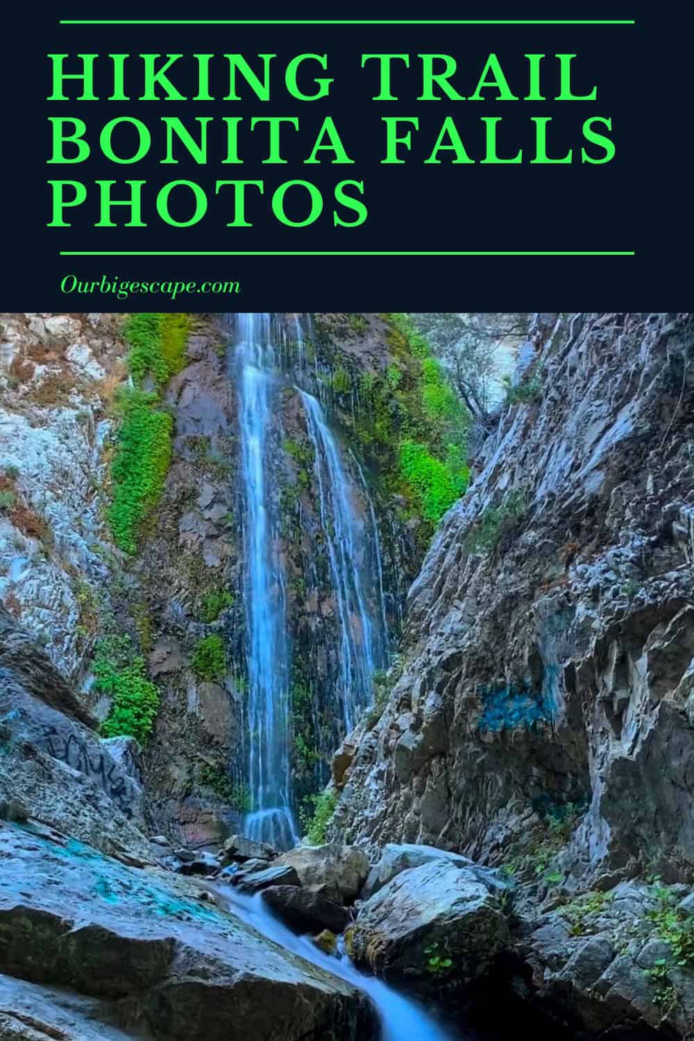
Discover this 1.5-mile out-and-back hiking trail Bonita Falls photos near Lytle Creek, California. Generally considered a moderately challenging route, it takes an average of 48 min to complete. This is a very popular area for hiking and walking, so you’ll likely encounter other people while exploring. The best times to visit this trail are March through October. Dogs are welcome, but must be on a leash.
Southern California National Forests Recreation Pass Details and Information Click Here
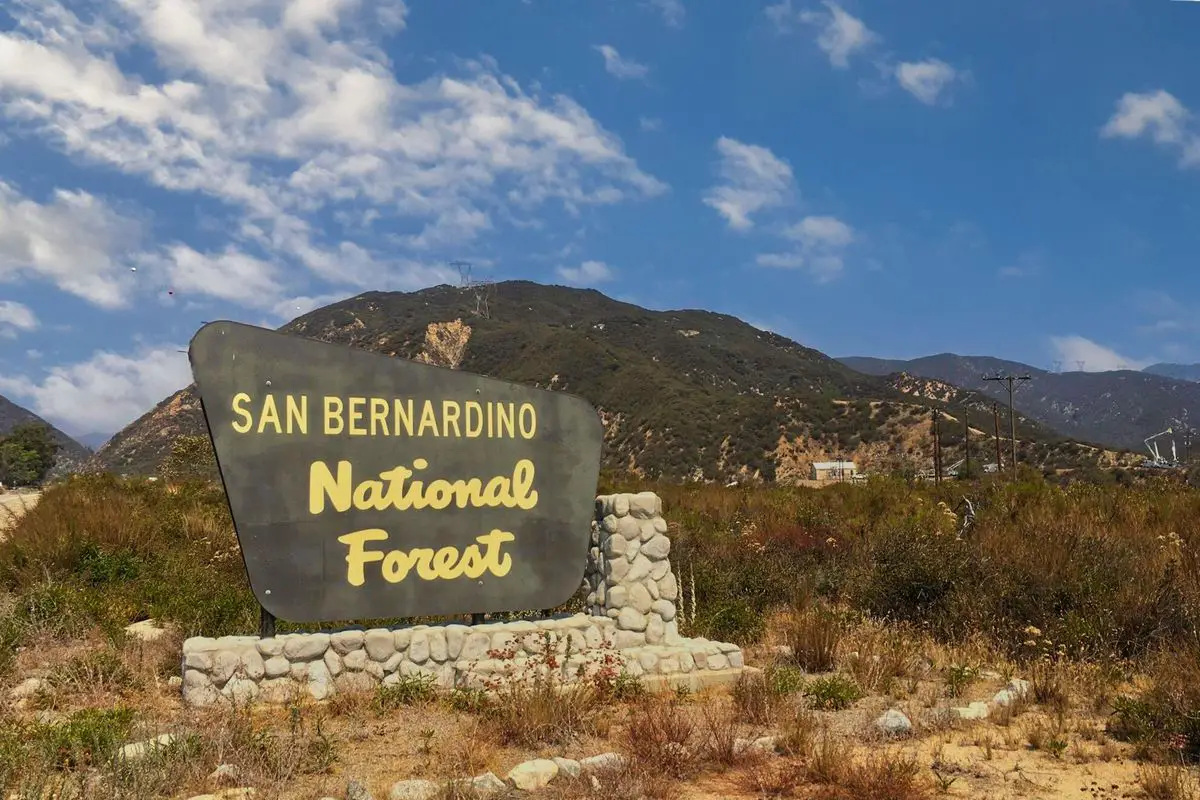
As of September 2016, forest visitors parked in standard amenity recreation fee sites in the four southern California national forests must display a valid recreation pass. This includes sites on the Angeles, Cleveland, Los Padres and San Bernardino National Forests.
As listed in the “Recreation Enhancement Act,” standard amenity fee sites are those that provide designated developed parking, picnic tables, toilet facilities, security, interpretive signs and trash receptacles. Information on valid recreation passes, such as the Adventure Pass and America the Beautiful (a National Parks and Federal Recreation Lands pass) can be found on the Passes and Permits page. Visitors do not have to display a valid recreation pass if they park outside these sites.
Click on the link below to open an interactive map showing all of the recreation fee sites in the four southern California national forests. Once one the map, visitors can go the “site picker” to select which forest they plan to visit. Once open, consider closing the “site picker” to view the entire map.
Local Stores Selling Southern California National Forests Recreation Pass Details Click Here
An adventure pass is required to be displayed in vehicles when using the Forest for recreation purpose. Information about where to purchase day/multi-day/annual passes can be found here:
Remember to stop at the Ranger Station or AMPM for your daily parking pass – $5. America The Beautiful passes also qualify
Want more ideas to round-out your trip to Bonita Falls?
A lot of great ideas are in these posts!
- Our Top 25 Yosemite Hikes For All Ages
- 16 Castle Mountains National Monument Boondocking Locations
- 20 Free Sequoia National Park RV & Camping Locations
- 18 Free Devils Postpile National Monument Boondocking Locations
- 23 Best Boondocking Spots Near Death Valley National Park
- 27 Top Joshua Tree National Park Boondocking Spots
Hiking Trail Bonita Falls Photos for Instagram
check out our video
Difficulty: Moderate
Length: 1.5 mi
Elevation gain: 334 ft
Route type: Out & back
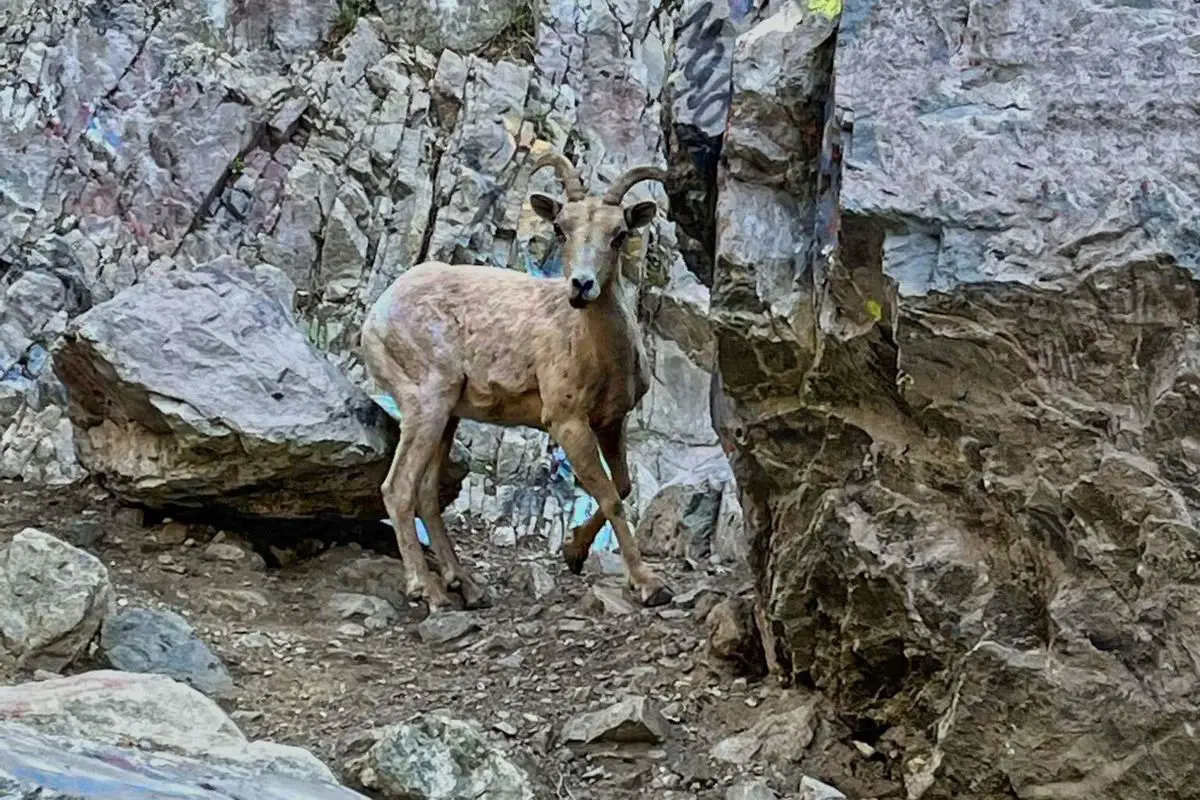
Dogs on leash, Hiking, Walking, Forest, River, Views, Waterfall, Wildflowers, Wildlife, Rocky, Fee
Description:
We have visited a lot of waterfalls in Southern California, including this one, we do love the hiking trail Bonita Falls photos ops. However, I believe that Bonita Falls would rank among my favorites if I had to choose just one. By the standards of Southern California, this magnificent waterfall’s height of nearly 100 feet is impressive.
The majority of people have gone to Bonita Falls, but many are unaware that there are two hidden tiers for hiking trail Bonita Falls photos that, when taken together, measure a whopping 495 feet!
The second-largest waterfall in the San Bernardino National Forest area, Bonita is a stunning waterfall that can be found in South Fork Lytle Creek. It’s a short 1.4-mile roundtrip hike. The majority of the trail is made up of a dry riverbed that doesn’t offer much in the way of a good hiking trail Bonita Falls photos spot. Just stones surrounded by rocky ridges, with the exception of a picturesque stream near the end.
It is a wonderful illustration of the hidden treasures that are frequently overlooked in our region and makes for a wonderful introduction to hiking for those who have never done it before. Having such a close waterfall inspired me to introduce many of my friends to both the hiking trail Bonita Falls photos that are available and the great outdoors.
The only issue I have with this waterfall is that every time I return, I find more and more graffiti there. If you are one of those people reading this, I can’t imagine why someone would want to do this, please stop!
Family-friendly fun awaits you on this trail! The trail is rocky because you will be walking in a wash and is less well-defined than other trails in Southern California. Therefore, it may be easier to carry a toddler for the majority of the distance when they are just learning to walk.
After finding a suitable parking spot, go down the embankment. If the water level is higher than mid-calf, you will need to find a safe area to cross the stream because the powerful current can easily knock you over. Find a place to cross that is shallow. You will then continue for about 3/4 of a mile up the canyon.
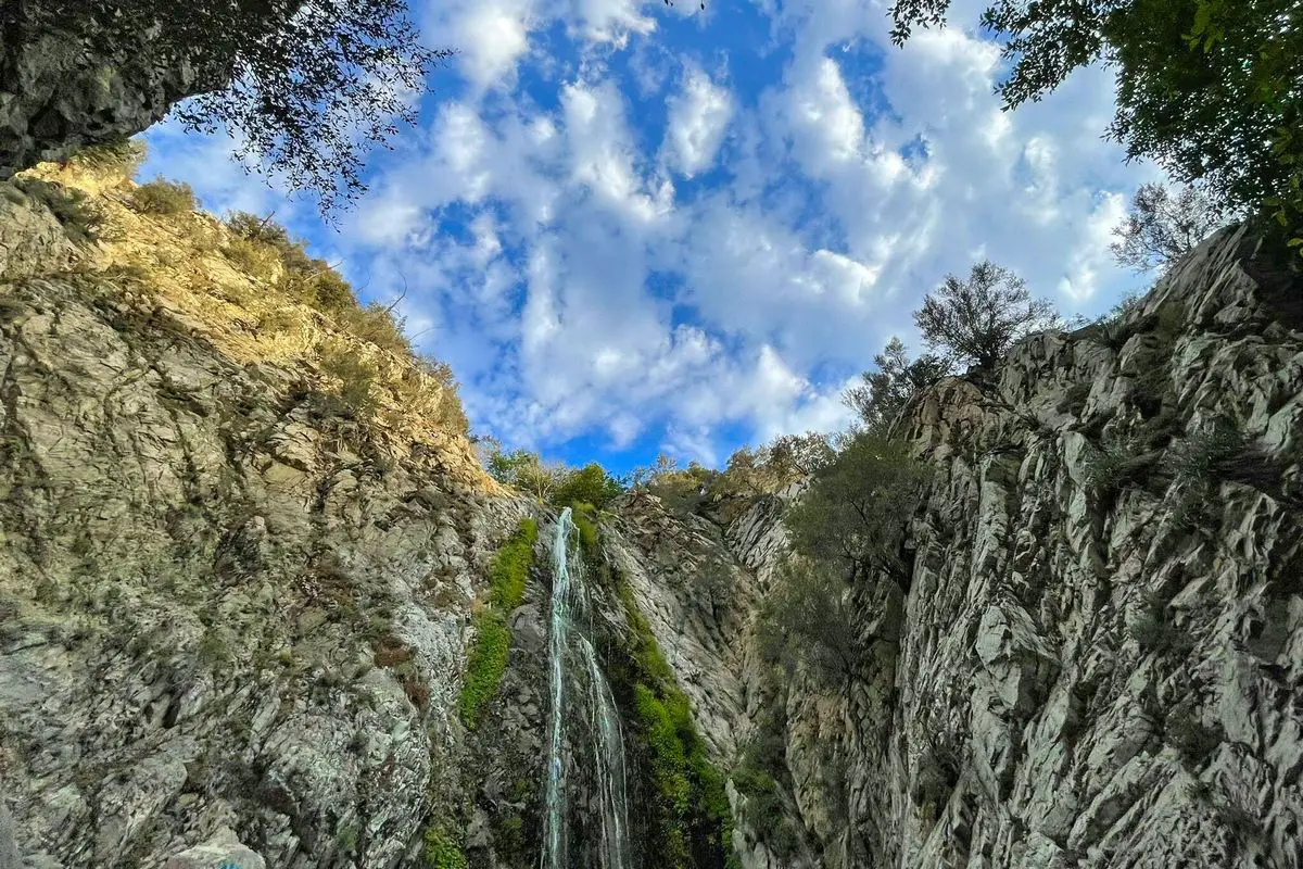
There are few trees and a clearly marked trail leading to the falls on the left side of the canyon. Reaching the alcove that conceals the falls requires climbing steep, rocky stairs. Once there, evaluate the risk for yourself in order to reach the base of the falls.
A year with high water levels is the best time to visit the hiking trail Bonita Falls photos spots.(best time to go is in the Spring after the first several rainstorms).

Hiking Tips for Bonita Falls Trail
If you’re starting your hike from Bonita Campground, get to the other side of the canyon because there is a “path” there.
The only route to the falls is along a dry riverbed with a lot of pebbles and rocks, the hike lacks a properly manicured trail.
It’s difficult to imagine, but during the region’s rainiest seasons, roaring floods have been known to happen.
Stay as far to the left as you can as you enter the canyon, and keep an eye out for a dirt road that ascends into the tributary (a smaller canyon with a creek feeding into the main canyon).
The trail will continue into a beautiful tributary; but, if it abruptly terminates, you’ve taken the incorrect path and must continue walking into South Fork along the riverbank.
The environment abruptly transforms from stony and desolate as you enter the tributary to lush, verdant flora.
The trail is lined with lovely cottonwood and white alder trees, as well as the infamous poison oak with its three-pronged leaves.
You’ll hear the sound of rushing water gushing over the edge of a 100-foot cliff in a matter of minutes. You are about to encounter a monster of a falls.
Finally, the boulder-climbing was worthwhile. Spanish for “beautiful,” the massive Bonita Falls certainly lives up to its name.
Unlike any other waterfall I’ve ever seen, Bonita sparkles in the sunlight. You’ll never forget the scene. Try to arrive at the falls between noon and two in the afternoon when the sun directly shines on the cascade to witness this for yourself. Just be mindful of the sizable crowds that are usually present.
Even though the pool is only about 2 feet deep and not deep enough for swimming, it is still worthwhile to cool yourself in the water supplied by the cold springs on the Cucamonga Wilderness’ north slope, especially on those exceptionally hot days.
Directions to Trailhead:
Directions from San Bernardino, CA: Take the Sierra Avenue exit north off of Interstate 15. The Ranger Station is located 5 miles up Lytle Creek Road to the north. Keep going for half a mile after Station. Park on the road where the dry creek bed is visible at the South Fork.
Cross the creek bed and continue hiking for half a mile to reach the cliffs’ left-facing gap. To reach the falls, hike up the mountain on your left.
(If you park along the main road, go across running creek, along the main road. Hike up dry creek bed half a mile to the break in the cliffs to the left. Hike up the mountain to the left to reach the falls.)
Review
The trail begins next to a spring-fed brook with prepared swimming holes. The trail next follows a dried-up riverbed and next to a graffiti-covered mountain wall. Follow the trail and the sound of the creek for a little distance up to the falls, you eventually turn left at an opening. Swimming was crowded when I arrived, but I managed to find a private spring down at the start to unwind in.
Very hot for a short hike. Nice creek-side trail, other than that it was rather exposed and flat. Up until the mountain’s start, there was a slight inclination and plenty of shade. The falls themselves were stunning and still had plenty of water. Bring a change of clothes with you. The water was cooling, but, often very crowded, so try visiting during the week.
5 Free San Bernardino National Forest Boondocking and Free Camping Locations
1. Clark’s Ranch Yellow Post Campsite
Address
Big Bear Lake, California
GPS: 34.183998, -116.977287
Elevation: 4994′
Management – Forest Service (USDA) (Official)
The road in is Dirt. There are 1-5 campsites at this location and the maximum RV length is small. You may stay 14 nights at this hiking trail Bonita Falls photos spot at Clark’s Ranch Yellow Post Campsite. This free campsite is a yellow post site in the San Bernardino National Forest.
There is only one campsite. It has a fire ring and nothing else. It offers an isolated scenic location ideal for tent and car camping or a relaxing picnic far from the crowds. This site is within a short driving distance of the Santa Ana River and Deer Creek. Other than a ring for campfires, this site does NOT contain the amenities found at developed campgrounds.
There is no water, no restrooms nearby, and no trash containers. Please pack it in – pack it out! Site is first-come, first-served.
2. Bear Creek Boondocking
7 Pines Road
Angelus Oaks, California
GPS: 34.164919, -117.014156
Elevation: 3514′
Management – Forest Service
Free Dispersed camping in the San Bernardino National Forest’s San Gorgonio Ranger District. No reservations. First come, first served.
3. Thomas Hunting Grounds Yellow Post Campites
1N12
Big Bear Lake, California
GPS: 34.128422, -117.005478
Elevation: 5890′
Management – Forest Service (USDA) (Official)
The road in is Dirt. There are 1-5 campsites at this location and the maximum RV length is small. You may stay 14 nights at Thomas Hunting Grounds Yellow Post Campsites and they all offer great hiking trail Bonita Falls photos.
Five free, remote camping sites in the San Bernardino National Forest locations for tent and car camping. There are some mature shade trees near the sites, but other than a metal fire ring for campfires, these sites do NOT contain the amenities found at developed campgrounds.
There is no water, no picnic tables, no restrooms nearby, and no trash containers. Please pack it in -> pack it out! All sites are first-come, first-served.
4. Santa Ana River Campsite
Angelus Oaks, California
GPS: 34.17422, -116.83913
Elevation: 6148′
Management – Forest Service (USDA) (Official)
People are friendly , there’s always someone around camping and many things to do! Sky is the limit on hiking trail Bonita Falls photos. beautiful sand and trees and plants. Great place to meditate.
5. East Jenks Lake RD E San Bernardino National Forest
Angelus Oaks, California
GPS: 34.165247, -116.849103
Elevation: 6775′
Management – national forest (Official)
The road in is Dirt and 500 yards? miles from a paved road. East Jenks Lake RD E San Bernardino National Forest is open when the snow melts . There are 16-29 campsites at this hiking trail Bonita Falls photos location and the maximum RV length is 35 feet.
You may stay 14 days at East Jenks Lake RD E San Bernardino National Forest.
5 Big Bear Lake Boondocking Sites – Permit Information Click Here
1. San Bernardino Yellow Post Site 30
2N86
Santa Rosa, California
GPS: 34.23143, -116.978302
Elevation: 7454′
Management – Forest Service (USDA) (Official)
The road into this San Bernardino National Forest boondocking area is Dirt. You may stay 14 at San Bernardino Yellow Post Site 30. Awesome hiking trail Bonita Falls photos site at the end of a very rutted, not RV friendly road. Some auto, motorcycle, & foot traffic, most needing directions. My dogs ran off a good sized bear here a few years back. So, as always, be careful.
YP30 is located on 2N86 at N34° 13.950 W116° 58.805
Lots of shade. Lots of parking. Room for 6 tents. Down a spur road.
Not RV friendly.
2. San Bernardino Yellow Post Site 25
2N44Y
Santa Rosa, California
GPS: 34.224705, -116.941467
Elevation: 7362′
Management – Forest Service (USDA) (Official)
The road in is 4×4. You may stay 14 at San Bernardino Yellow Post Site 25. YP25 is located on 2N44Y at N34° 13.363 W116° 56.449.
Lots of shade all day long and a good hiking trail Bonita Falls photos spot. A small creek is flowing near camp. Room for 2 tents.
Currently there is not a table or fire ring. There is a hiking trail that cuts right through the campsite. Not recommended for RV’s by the USFS. The creek may attract a lot of bugs.
3. San Bernardino Yellow Post Site 26
2N52Y
Santa Rosa, California
GPS: 34.21896, -116.944191
Elevation: 7547′
Management – Forest Service (USDA) (Official)
The road in is 4×4. You may stay 14 at San Bernardino Yellow Post Site 26. YP26 is located on 2N52Y at N34° 13.027 W116° 56.694
Wide open area hiking trail Bonita Falls photos location. Down a spur road (less traffic). Can fit 4 tents and vehicles or an RV.
4. San Bernardino Yellow Post Site 29
2N11
Santa Rosa, California
GPS: 34.213753, -116.967445
Elevation: 7755′
Management – Forest Service (USDA) (Official)
The road in is Dirt. You may stay 14 at San Bernardino Yellow Post Site 29. YP29 is located on 2N11 at N34° 12.950 W116° 58.650
Some shade. Room for 3 vehicles. Down a spur road.
Not much flat space for tents. Not RV friendly.
5. San Bernardino Yellow Post Site 27
2N10D
Santa Rosa, California
GPS: 34.212288, -116.956741
Elevation: 7850′
Management Forest Service (USDA) (Official)
You may stay 14 at San Bernardino Yellow Post Site 27. Yellow Post 27
YP27 is located on 2N10D at N34° 12.896 W116° 57.359
Lots of shade. A small creek is flowing near camp. Down a spur road. Room for a couple of vehicles and tents. A perfect hiking trail Bonita Falls photos spot. Low profile cars will not make it all the way to camp. No RV’s
The road into this San Bernardino National Forest boondocking area is Dirt. There are 1-5 campsites at this location and the maximum RV length is small. You may stay 14 nights at this hiking trail Bonita Falls photos spot at Clark’s Ranch Yellow Post Campsite. This free campsite is a yellow post site in the San Bernardino National Forest.
There is only one campsite. It has a fire ring and nothing else. It offers an isolated scenic location ideal for tent and car camping or a relaxing picnic far from the crowds. This site is within a short driving distance of the Santa Ana River and Deer Creek. Other than a ring for campfires, this site does NOT contain the amenities found at developed campgrounds.
There is no water, no restrooms nearby, and no trash containers. Please pack it in – pack it out! Site is first-come, first-served.
You May Want to Join Our Boondocking Group on Facebook For More Information
You May Want to Join Our Campfire Recipes Group on Facebook For More Information