
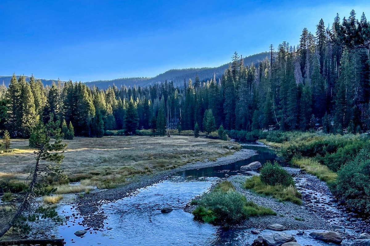
The Devils Postpile National Monument in the Sierra Nevada mountain range is home to countless displays of natural beauty.
Stunning vistas, gorgeous waterfalls, and diverse wildlife can be seen all over the region. While there are many sights to be seen in the Sierra Nevada, one of the most memorable is the Devils Postpile National Monument.
Want more ideas to round-out your trip to California?
A lot of great ideas are in these posts!
- 6 Top Pinnacles National Park Boondocking Locations
- 14 Redwood National Park Boondocking (Updated 2022)
- 18 Kings Canyon National Park Boondocking (Updated 2022)
- 15 Yosemite National Park Camping Spots (Updated 2022)
- 5 Death Valley Salt Flats Boondocking (Updated 2022)
- 419 Awesome California Boondocking Campsites And Maps
- Our Top 25 Yosemite Hikes For All Ages
- 5 Best Hiking Trail Bonita Falls Photos Hot Spots
- 8 Places to Visit in Sequoia National Park
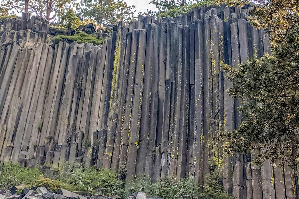
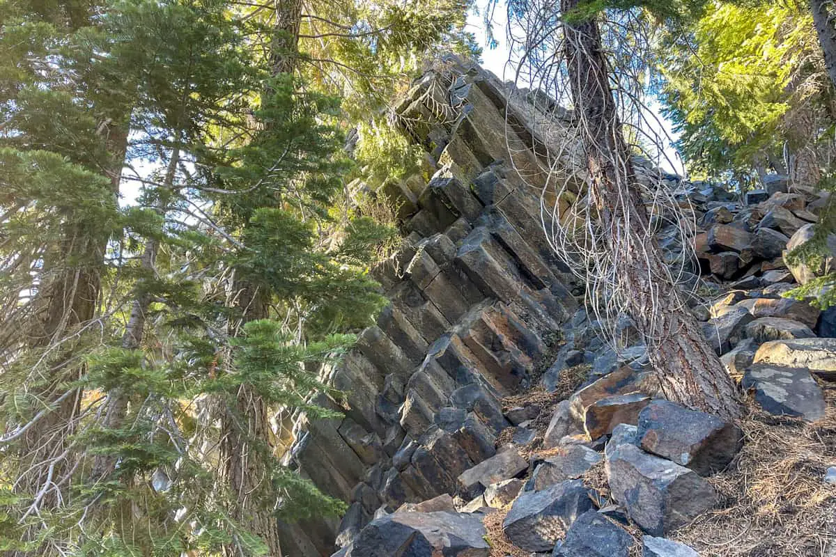
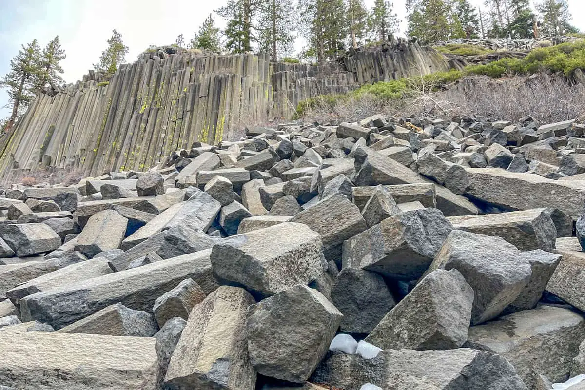
The Devils Postpile National Monument is a surreal sight. Found near the storied Rainbow Falls, the monument features a rare geological formation known as columnar basalt. It is one of the best examples of this landscape oddity that can be found anywhere on the planet. Some of the “posts” tower up to 60 feet high, jutting out against the Sierra Nevada in an awe-inspiring display of natural symmetry.
History of the Devils Postpile National Monument
So, how does nature create such symmetry? To answer this question, we must look back to the ancient geological events that directly led to the Postpile’s formation. Far before there was land in the region now known as California, it was simply a shallow sea.
As the tectonic plates moved closer together, the land arrived piece-by-piece, attaching to what is now the continental United States. The immense pressure and friction caused by the tectonic plates moving together eventually created the Sierra Nevada mountain range.
A side-effect of the compressing tectonic plates was that lava flows broke free from the earth’s crust, leading to interesting geological formations. The direct precursor to the Devils Postpile National Monument, for instance, was a basaltic lava vent that created a lava lake as deep as 400 feet. This type of depth is exceedingly rare in volcanic activity — but was necessary to the formation of the Postpile.
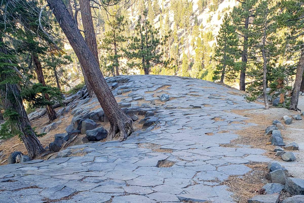
As the basaltic lava cooled, it began to form into the columns that can be observed today. This happens through a process geologists call “jointing”. In the case of the Devils Postpile National Monument, the cooling lava jointed into the famous columns. Finally, a glacial event polished the tops of the columns, revealing an unusual hexagonal pattern.
It is exceedingly rare that all of these geological events could end up creating the famous symmetrical formation. That makes the Devils Postpile National Monument even more special. This was a fact recognized by a presidential proclamation in 1911, which gave the Postpile federal protections.
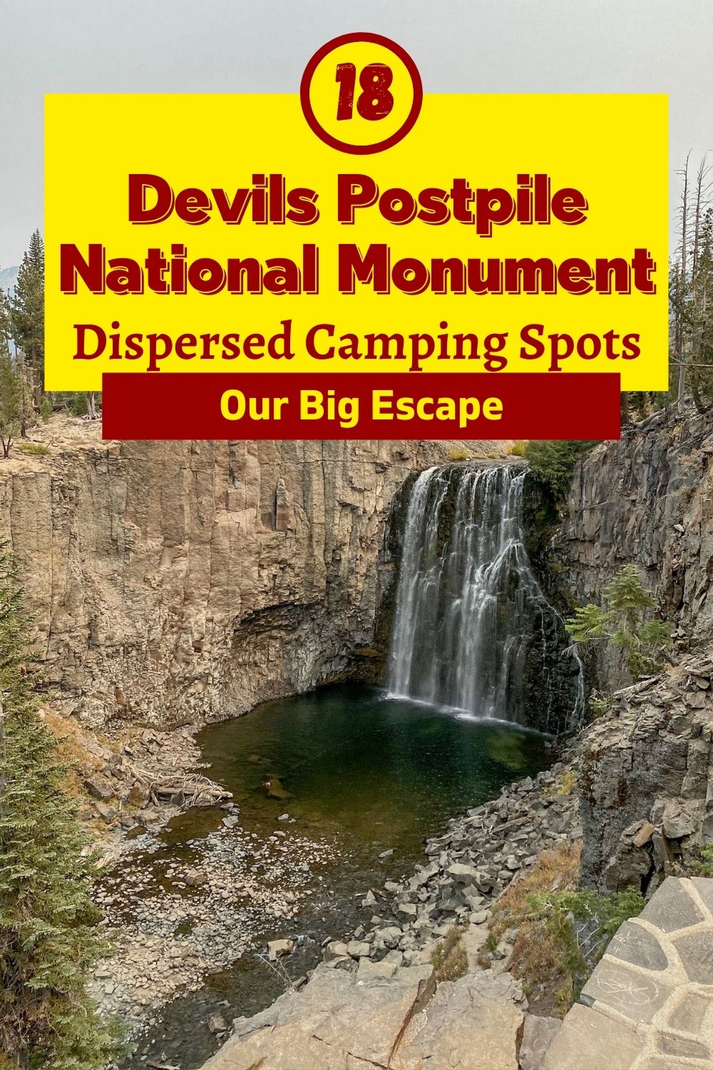
18 Devils Postpile National Monument Boondocking Locations
check out our video
1. Devils Postpile National Monument Boondocking Locations – Mammoth Scenic Loop
Address
Mammoth Lakes, California
GPS: 37.688711, -118.989347
Elevation: 7927′
Management: National Forest Service
The road into this Devils Postpile National Monument free campsite area is gravel. There are 30 or more campsites at this location and the maximum RV length is unlimited.
Best Review:
A boondocker buffet. There is dispersed camping all along this road. It is Forest Service land. It does turn into City of Mammoth as you get closer to town. I spent a few nights this winter in a plowed turn out. Works well if they are not plowing.

2. Devils Postpile National Monument Boondocking Free Campsites – Lower Deadman Campground
Address
Deadman Creek Road
June Lake, California
GPS: 37.720322, -119.009445
Elevation: 7796′
Management: National Forest Service
The road into this Devils Postpile National Monument free boondocking area is gravel and 3 miles from a paved road. Lower Deadman Campground is open Summer. There are 6-15 campsites at this location and the maximum RV length is 45′. You may stay 21 day stay limit at Lower Deadman Campground.
Best Review:
There is a lower and upper campground, and we camped in upper this weekend for the first time. Years past we’d camped near the entrance of deadman creek (not actual campsites). The campground was a nice change with picnic tables, fire pits and bathrooms (toilet only). It’s right next to a creek and quite gorgeous. We will definitely be back and I recommend this campground to anyone.
3. Devils Postpile National Monument Boondocking Spots – Dry Creek Mammoth Lakes
Address
Bishop, California
GPS: 37.70184, -118.96181
Elevation: 7644′
Management: National Forest Service
The road into this Devils Postpile National Monument free campsite area is dirt and .5 miles from a paved road. Dry Creek Mammoth Lakes is open October 2018. There are 1-5 campsites at this location and the maximum RV length is 25 feet. You may stay Unknown at Dry Creek Mammoth Lakes.
Best Review:
This is large flat campsite in the Inyo National Forest with a fire ring nestled in the pines. It’s one of many down a small dirt road. This one is not far off the main road – you can still hear the faint sound of cars. But, it’s tucked into a side of the hill with large pine trees all around. Very quiet.
4. Devils Postpile National Monument Boondocking Locations – Laurel Springs Camping Area
Address
Mammoth Lakes, California
GPS: 37.617283, -118.895828
Elevation: 7202′
Management: National Forest Service
A couple of well spaced, free campsites. Some are adjacent to a nice little creek. Located about 8 miles from the town of Mammoth Lakes.
Best Review:
Only one (very sunny) campsite can really accommodate a large rig. The others are small and are not level. Shade comes from Aspens. Not far from highway 395. The road into this Devils Postpile National Monument free boondocking area is dirt.
5. Devils Postpile National Monument Boondocking Free Campsites – Glass Creek Campground
Address
Glass Creek Road
June Lake, California
GPS: 37.75341, -118.997894
Elevation: 7659′
Management: National Forest Service
The road into this Devils Postpile National Monument free campsite area is dirt. Glass Creek Campground is open summer-fall. There are 30 or more campsites at this location and the maximum RV length is 45′. You may stay 21 day stay limit at Glass Creek Campground.
Best Review:
We stayed in this campground for 2 nights and we like it very much! Although no water & electricity supplies, it is still a very nice campground. It is free, easy accessible, clean and very spacious.
6. Devils Postpile National Monument Boondocking Spots – Granite Creek Campground
Address
California
GPS: 37.538208, -119.264557
Elevation: 6972′
Management: National Forest Service
The road into this Devils Postpile National Monument free boondocking area is dirt. The maximum RV length at Granite Creek Campground is 20 feet. Located along Granite Creek, Granite Creek Campground has two loops containing 20 campsites. Fir trees provide a good amount of shade at campsites.
Best Review:
None
7. Devils Postpile National Monument Boondocking Locations – Inyo National Forest
Address
Mammoth Lakes, California
GPS: 37.736105, -118.962852
Management: National Forest Service
Many free camping site in this area along 395 and Owens Creek rd. I’m here on Owens Creek road first pull off east of 395. Beautiful weather forest scenery OHV trails everywhere. The road into this Devils Postpile National Monument free campsite area is dirt.
Best Review:
I stayed at the first site north of Owens Creek Rd. Exact GPS for the site is 37.737313, -118.969148. For being close to the highway, I couldn’t hear any vehicles at all. Other campers came and went, but the sites are spaced so that you hardly notice other rigs or people. Verizon cell service was great. The whole area is just beautiful. However, I left after 2 nights due to the chipmunks getting in my van. I sprayed peppermint oil on and around my tires to deter any rodents but the little buggers still got into my engine.
8. Devils Postpile National Monument Boondocking Free Campsites – Hartley Springs Campground
Address
Forest Road 2S48
June Lake, California
GPS: 37.771568, -119.037842
Elevation: 8434′
Management: National Forest Service
The road into this Devils Postpile National Monument free boondocking area is dirt. Hartley Springs Campground is open summer-fall. There are 16-29 campsites at this location and the maximum RV length is 45′. You may stay 21 day stay limit at Hartley Springs Campground.
Best Review:
I love this campsite, it’s hands down one of my favorites. Although the dirt road in is rough and uneven, it’s a beautiful free campground. Toilets, tables, fire rings, ATV and even if you don’t ride its great. We’ve come back to the site so many times.
9. Devils Postpile National Monument Boondocking Spots – Big Springs Campground
Address
Owens River Road
June Lake, California
GPS: 37.749119, -118.939407
Elevation: 7280′
Management: National Forest Service
There are 16-29 campsites at this location. Free camping in the Inyo National Forest.Located 13 miles north of Mammoth Lakes and 20 miles south from the junction of highway 395 and Tioga Pass (The gateway to Yosemite). The road into this Devils Postpile National Monument free campsite area is dirt.
Best Review:
I love this free campground. It is close to Mammoth Lakes and June Lake with many hiking trails nearby. There is a bold creek bordering the campground providing water for a solar shower. Most campsites have a mixture of sun and shade. I was lucky enough to get a site close to the creek with morning sun and afternoon shade. Each site has a fire pit, a table and a bear locker. The ground is generally soft with pine needles making tent camping comfortable. It is quiet and dark at night. The vault toilets are clean and always well stocked with toilet paper.
10. Devils Postpile National Monument Boondocking Locations – Owen River Rd
Address
GPS: 37.7497, -118.93133
Elevation: 7313′
Management: Public
Dispersed free camping all along the road. No facilities but large enough for RV parking. The road into this Devils Postpile National Monument free boondocking area is dirt.
Best Review:
None
11. Devils Postpile National Monument Boondocking Free Campsites – Forest Service Camping and Hot Springs
Address
Mammoth Lakes, California
GPS: 37.690602, -118.843028
Elevation: 6998′
Management: National Forest Service
Huge valley criss-crossed with dozens of Forest Service roads and myriad places to camp. The road in is Gravel. Tons of free Forest Service camping and hot springs is open year round. You may stay 14 days at Tons of free Forest Service camping and hot springs. The road into this Devils Postpile National Monument free campsite area is dirt.
Best Review:
None
12. Devils Postpile National Monument Boondocking Spots – Pulkey’s Pool
Address
Mammoth Lakes, California
GPS: 37.660382, -118.789437
Elevation: 6874′
Management: National Forest Service
The road into this Devils Postpile National Monument free boondocking area is dirt and .5 miles from a paved road. There are 1-5 campsites at this location and the maximum RV length is 15 feet.
Best Review:
Please, don’t camp too close to the hot springs themselves, it’s not allowed by the DWP/BLM/whomever sanctions this land to our activities. They might close access if this sort of thing keeps up, which would be a damn shame. There is plenty of land to camp nearby that does not impinge on the pool areas themselves.
13. Devils Postpile National Monument Boondocking Locations – Bald Mountain Spring Campground
Address
Bald Mountain Spring Road
Mammoth Lakes, California
GPS: 37.792599, -118.881302
Elevation: 8233′
Management: National Forest Service
Bald Mountain Spring Campground is open summer. You may stay 28 days at Bald Mountain Spring Campground.
Best Review:
Free, very lightly used campground in an OHV area near Bald Mountain Spring. Up the road you will find Bald Mountain Lookout Station This is a dispersed camping area. There are no designated campsites. The road into this Devils Postpile National Monument free campsite area is dirt
14. Devils Postpile National Monument Boondocking Free Campsites – Wild Willy’s Area
Address
Mammoth Lakes, California
GPS: 37.656689, -118.76872
Elevation: 6864′
Management: Bureau of Land Management
The road into this Devils Postpile National Monument free boondocking area is dirt and 1.5 miles from a paved road. There are 1-5 campsites at this location.
Best Review:
The road was open and the bathroom was clean with no TP. No fires were permitted. The pools were loud but some of the tent sites are far enough from the parking lot that they were quiet. Nice birding. The road in was tricky in a low clearance sedan. There was a fair amount of trash.
15. Devils Postpile National Monument Boondocking Spots – Bloody Canyon
Address
Sawmill Canyon Road
Lee Vining, California
GPS: 37.874087, -119.1473
Elevation: 7808′
Management: National Forest Service
This free campsite is located within the Inyo National Forest’s Mono Lake Ranger District. This is a high elevation location. Bloody Canyon is open Jun-Oct. The road into this Devils Postpile National Monument free campsite area is dirt
Best Review:
16. Devils Postpile National Monument Boondocking Locations – Bloody Canyon Trailhead Campground
Address
June Lake Loop
June Lake, California
GPS: 37.872517, -119.158775
Elevation: 8351′
Management: National Forest Service
There are 1-5 campsites at this location. You may stay 14 days at Bloody Canyon Trailhead Campground. Four free campsites at trail head for Bloody Canyon Trail. No services at all – no water, no toilets, etc. Pets are OK if leashed. Elevation: 8,400′. The road into this Devils Postpile National Monument free boondocking area is dirt.
Best Review:
These are hike in only sites and about a mile from the parking lot on the opposite site of the lake.
17. Devils Postpile National Monument Boondocking Free Campsites – Crooked Meadows Campground
Address
Crooked Meadow Road
Mammoth Lakes, California
GPS: 37.819401, -118.8507
Elevation: 8823′
Management: National Forest Service
Free, primitive camping out in the boondocks. Moderate-high use campground with at least two obvious sites, toilet facilities, signs, and fire rings.
Best Review:
Campground at end of Route 01S17B at the southwestern edge of Crooked Meadows. At about 8800′ elevation. No reservations. First come, first camped.
18. Devils Postpile National Monument Boondocking Spots – Sample Meadow Campground
Address
Lakeshore, California
GPS: 37.33314, -119.15334
Elevation: 7828′
Management: National Forest Service
Sample Meadow Campground is open during summer. There are 16-29 campsites at this location. You may stay 14 days at Sample Meadow Campground.
Best Review:
None
10 Of the Best Trails That Pass Through, and Around the Area
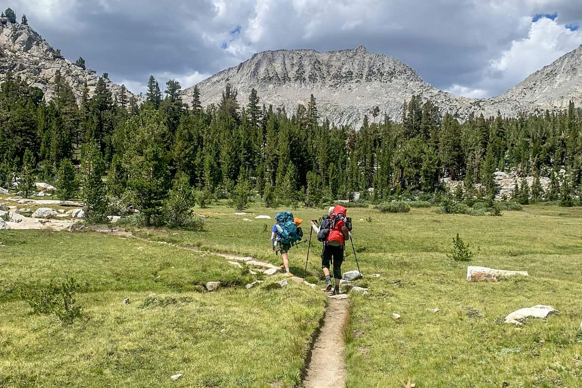
There are about eight miles of trails in Devils Postpile National Monument. The trails offer a variety of opportunities for all fitness levels. Expanding your hiking outside the boundaries of the monument will take you into the High Sierra of the Ansel Adams Wilderness. If hiking with your pet, it must be on a leash at all times while within the monument.
All of the following distances are round trip and from the Devils Postpile trailhead near the ranger station.
Devils Postpile National Monument Hiking Trail #1. Devil’s Postpile Through Mammoth Pass
This trail, though it is moderately difficult, is well worth the hike. At about 15 miles long, the loop trail leads through Red’s Meadow Resort, and past the Rainbow Falls and Lower Falls area of the monument. Due to elevation, it is possible that hikers will need to cross patches of snow.
Despite the snow, the summer heat can be quite intense when you get back to lower elevations. For this reason, it is highly-recommended that hikers bring plenty of water. If you need a refill, you could stop at Red’s Meadow Resort for some water.
Length: 14.8 mi
Elevation gain: 3,123 ft
Route type: Loop
Dogs on leash, Hiking, Nature trips, Walking, Forest, Views, Waterfall, Wildflowers, Wildlife
Devils Postpile National Monument Hiking Trail #2. Devil’s Postpile and Rainbow Falls via Mammoth Pass Trail
As an alternative to the above trail, a Devil’s Postpile National Monument visitor might elect to use this shorter trail to visit the main attractions of the region. Offering access to both Rainbow Falls and the Devil’s Postpile, this well-marked and easy to follow trail is quite popular among backpackers and hikers.
Of course, bringing lots of water is always recommended. It is also prudent to maintain awareness of the effects of elevation — take frequent breaks! That said, the cell phone service is passable in the area if you should need to call for help or to check in with other hikers.
Length: 12.8 mi
Elevation gain: 2,611 ft
Route type: Out & back
Dogs on leash, Backpacking, Hiking, Forest, River, Views, Waterfall, Wildflowers, Wildlife
Devils Postpile National Monument Hiking Trail #3. Rainbow Falls via Devil’s Postpile Trail
One of the most popular trails at the Devil’s Postpile National Monument, this shorter trail can be accessed via a mandatory shuttle. If you want to drive there on your own, you must get to the park prior to 7am. The trailhead is approximately a 20 minute drive from the park entrance.
The hike on this trail is short and easy. That said, the trail can be crowded since it is one of the few that offers shuttles to the trailhead. If you arrive early in the morning, you might be able to miss the crowds — but be prepared for it to be chilly!
The trail leads to Rainbow Falls, but you can also hike down to the Lower Falls area by adding a little under a mile to your hike. And we’ll say it again — bring LOTS of water. This trail has little shade and can get very hot, especially during the summer months.
Length: 4.9 mi
Elevation gain: 515 ft
Route type: Out & back
Dogs on leash, Kid friendly, Hiking, Forest, River, Views, Waterfall
Devils Postpile National Monument Hiking Trail #4. Devil’s Postpile Loop
One of the shortest trails offered at the Devil’s Postpile National Monument is the Devil’s Postpile Loop. It is a simple and easy trail, featuring educational signs about the history and geology of the area. It is possible to park in the area — just arrive early because the parking lot will fill fast!
If you have small children, this is definitely a top-recommended trail for the area. Your kids will be able to hike 95% of the trail unassisted. And don’t forget to pick up a Junior Ranger booklet. This can be found at the ranger station near the parking lot — and it even comes with a badge!
Length: 1.3 mi
Elevation gain: 232 ft
Route type: Loop
Dogs on leash, Kid friendly, Hiking, Forest, River, Views, Wildflowers, Wildlife
Devils Postpile National Monument Hiking Trail #5. John Muir Trail: Devil’s Postpile to Yosemite Valley
For the more adventurous among us, the John Muir trail is a LONG trail (53+ miles) that can take a week or longer to hike. Even though the difficulty is high, this trail is well worth it for an experienced hiker. The beauty, serenity, and views are unmatched. That said, the difficulty of the hike should not be understated.
For instance, in the meadow area, the mosquitoes can become a major nuisance. It is recommended to bring large quantites of mosquito repellant and to sleep under a bug net. Bears are also present in the area, so bear-proofing measures should be taken (i.e., locking up food). It may be prudent to carry bear spray in the unlikely event of an attack.
While the John Muir trail isn’t an easy one, it is a gorgeous one. And hiking the whole trail would be quite an accomplishment!
Length: 53.2 mi
Elevation gain: 8,710 ft
Route type: Point to point
Backpacking, Camping, Fishing, Hiking, Nature trips, Bird watching, Forest, River, Views, Waterfall, Wildflowers, No dogs
Devils Postpile National Monument Hiking Trail #6. Agnew Meadows to Devil’s Postpile
For a more moderate trail, the Agnew Meadows to Devil’s Postpile trail offers a peaceful experience to hikers. One of the most striking parts about hiking this trail is the incredible variety of wildflowers. Wildlife can also be spotted. Few people hike this trail, so it is more private for hikers seeking a meditative experience. One of the downsides is that the insects can be a nuisance. For this reason, it is recommended that hikers bring mosquito repellant.
Length: 12.6 mi
Elevation gain: 1,650 ft
Route type: Out & back
Hiking, Nature trips, Walking, Bird watching, Dog friendly, Views, Wildflowers, Wildlife
Devils Postpile National Monument Hiking Trail #7. Devil’s Postpile Ranger Station to Fern Lake
Categorized as a moderately difficult trail, the Devil’s Postpile Ranger Station to Fern Lake trail is best enjoyed with an early start. Hikers will be awed by the quiet serenity of Fern Lake once they reach the top of the trail. Surrounded by meadows, Fern Lake has often been lauded as one of the most stunning lakes in the region.
This trail is not travelled as often as some of the other trails in the area, so it offers a quiet experience. It is highly recommended that hikers bring plenty of water on this trail, as it gets quite hot during the day.
Length: 8.9 mi
Elevation gain: 2,234 ft
Route type: Out & back
Dogs on leash, Hiking, Nature trips, Walking, Bird watching, Forest, Lake, Views, Wildflowers
Devils Postpile National Monument Hiking Trail #8. Devil’s Postpile, Beck Lake, and Shadow Lake Loop
For those seeking a multiple-day experience, but who aren’t quiet up to the John Muir trail, the Devil’s Postpile, Beck Lake, and Shadow Lake Loop may be a good option. It can take 3-4 days to hike this trail in its entirety. For those with elevation concerns, you should note that the elevation gains from Devil’s Postpile to the lakes can be intense.
On the way back, however, the elevation will gradually decline and start to become easier. This 28.5-mile loop is very well-maintained. There won’t be many other hikers on the trail, but there are many spots to stop and fill up or filter your water. It’s very important to bring a lot of water — something that we cannot stress enough!
Length: 28.5 mi
Elevation gain: 5,590 ft
Route type: Loop
Dogs on leash, Backpacking, Camping, Fishing, Hiking, Nature trips, Bird watching, Forest, Lake, River, Views, Waterfall, Wildflowers, Wildlife
Devils Postpile National Monument Hiking Trail #9. Devil’s Postpile, 1000 Island Lake, Agnew Meadows
For an experienced hiker, this trail may be worth checking out. It is considered to be a very difficult trail, but the beauty of the lakes, rivers, and waterfalls is well worth the effort of hiking it. It is a well-maintained trail that connects with other trails all over the Devil’s Postpile National Monument region. This is the kind of trail that only experienced individuals should attempt; amateur hikers should probably work their way up to a trail of this level.
Length: 19.0 mi
Elevation gain: 4,609 ft
Route type: Point to point
Backpacking, Camping, Hiking, Nature trips, Bird watching, Forest, Lake, River, Views, Waterfall, Wildflowers, Wildlife
Devils Postpile National Monument Hiking Trail #10. Pacific Crest Trail: Red’s Meadow to Minaret Falls Trail Junction
One of the best trails to use for those wishing to connect to the Minaret Falls Trail from the Devil’s Postpile National Monument is the Pacific Crest Trail. It’s a fairly short trail (5 miles) but allows those hiking either trail system access to the other. While the trail is only moderate in difficulty, be sure to check the weather before heading out — it is not unheard of for it to snow quite frequently in this area.
Length: 4.8 mi
Elevation gain: 646 ft
Route type: Out & back
Dogs on leash, Hiking, Horseback riding, Running, Forest, Views, Wildflowers, Wildlife
Attractions at the Devil’s Postpile National Monument
While the Postpile itself is reason enough to visit the area, there are other attractions that are worth mentioning as well. For instance, the region is incredibly biodiverse. Birdwatchers, wildlife enthusiasts, and other nature lovers will appreciate the high species diversity of the area. For instance, one could observe eagles in the mountains, or black bears living among the pines, firs, and diverse wildflowers of the area.
1. History Research
For the history buffs among us, the Devil’s Postpile National Monument also offers a glimpse into the past via some older structures and settlements in the area. For instance, the Minaret Mine is located onsite. This mine was established in 1878, but never was fully developed. It was active until the 1930s, but the remote location stood in the way of profit. In fact, extensive mining has never taken place in the area.
2. Postpile Cabin
Another structure, the Postpile Cabin, once stood at the base of the Postpile itself. While the origins of the cabin are unclear, some have postulated that it was built by a settler named Red Sotcher in 1878. If true, he had interesting architectural tastes.
The cabin featured deeply-recessed windows and an unusal type of roof — features not often seen in the Sierra Nevada region. While the cabin unfortunately collapsed under heavy snow in 1954, a visitor could still see the large stone hearth and the foundation of the cabin at the base of the columns.
3. Minaret Mine
While the Minaret Mine and the Postpile Cabin are largely defunct, one historical building still stands and is still used to this day. The Postpile Ranger station, built in 1941, serves as the current visitor contact station. It features some Postpile exhibits and remains in excellent condition.
4. Ranger Pass for Kids
The Devil’s Postpile National Monument is also quite kid-friendly! At the Postpile Ranger station, one can enroll their children in ranger-led programs that are held every day during the summertime. Whether it be via hiking or wildlife talks, the little ones are sure to enjoy themselves just as much as the adults. Top 10 Trails to Hike at the Devil’s Postpile National Monument.
You May Want to Join Our Boondocking Group on Facebook For More Information
You May Want to Join Our Campfire Recipes Group on Facebook For More Information