
Interestingly enough, the Deep Creek Trail was one of the first constructed by the Civilian Conservation Corps in the 1930s. But you would have no idea because the trail is absolutely beautiful and so well-maintained.
The streams and waterfalls in the Deep Creek Trail area are well known. There are several loop trails that hikers can take to get to the waterfalls all beginning at the Deep Creek Trail Trailhead. Mountain bikers can ride on one of the few trails in the park where bikes are allowed.
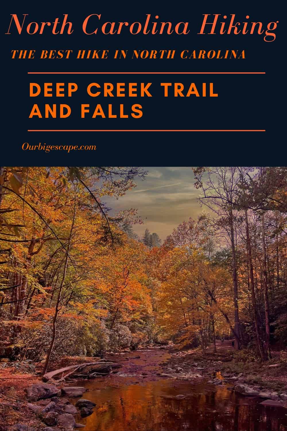
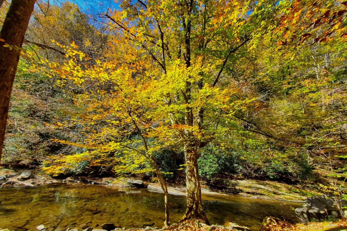
Visit the Deep Creek trail, a beautiful route with three waterfalls. Start at the Deep Creek Trail Trailhead for this 4.9-mile loop trail near Bryson City, North Carolina. Most people think of it as a moderately hard route, which takes an average of 2 hours and 20 minutes to finish. This is a popular place to hike, so you’ll probably run into other people while you’re there. The trail is beautiful and can be used at any time of year. Dogs can’t go on this trail, so you’ll have to leave them at home.
Difficulty: Hard
Length: 4.9 mi
Elevation gain: 895 ft
Route type: Loop
Kid friendly, Hiking, Forest, River, Views, Waterfall, Wildflowers, Wildlife, Rocky, No dogs
Want more ideas to round-out your trip to the South-Eastern States?
► Alabama, Arkansas, Florida, Georgia, Louisiana, Mississippi, North Carolina, South Carolina, Tennessee ◄
- 94 Free Arkansas Boondocking Locations
- 29 Free Alabama Boondocking Locations
- 52 Best Louisiana Boondocking and Free RV Parking Spots
- 87 Best Mississippi Boondocking and Free RV Parking Spots
- 77 Great Georgia Boondocking – Free RV Parking & Camping Locations
- 90 Free Florida Boondocking – RV Parking and Camping Sites
- 61 Free North Carolina Boondocking – RV Parking & Camping Spots
- 26 Free South Carolina Boondocking Spots – RV Parking & Camping
- 34 Free Tennessee Boondocking – RV Parking & Camping Spots
3 Reasons To Visit the Great Deep Creek Trail
check out our video
Deep Creek Trail is our favorite hiking area in the Great Smoky Mountains National Park, as it offers a big variety of scenery, including three waterfalls. Located just a few miles from downtown Bryson City, Deep Creek is a popular summer spot for camping and tubing.
During the other months, the crowds leave for a much quieter trek along the whitewater rapids. This is one of our top winter hiking destinations since it’s a lower elevation that receives little snow. No pets are allowed on these trails. Read more about the Deep Creek area.
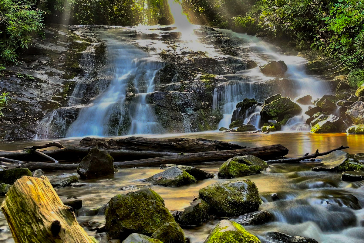
To see all three waterfalls, you have several options for hiking routes beginning at the Deep Creek Trail Trailhead. The shortest option is 2.4 miles. The Deep Creek Trail-Indian Creek Loop is 5 miles.
Juney Whank Falls by Timothy WIldey
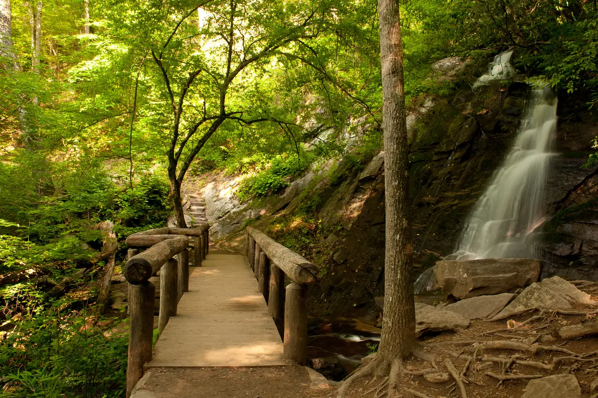
Juneywhank Falls — From the Deep Creek trailhead parking area, follow the well-marked trail 1/4 mile uphill to Juneywhank Falls. The roar of the falls can be heard even before you reach it. An eighty-foot cascade of water starts above you and runs under a log footbridge with handrails, and meets up with Deep Creek at the bottom of the trail.
Heading on down Deep Creek Trail, you’ll run into a spur that takes you to Juney Whank Falls. You’ll see signs. The trail does get a bit confusing, and you can either go right or left. You’ll want to go left. You’ll know you’re heading in the right direction by the steep include. This is a pretty steep climb for a bit, and then the rest is downhill. The spur trail to the falls is about 1.2 miles, but it’s really worth it and from the falls, you are very close to the parking lot.
Trails to each waterfall are short. See the 90-ft. Juney Whank Falls (pic) via a steep, well-marked, 1/4-mile trail from the Deep Creek Trailhead parking area.
Tom Branch Falls by SR Benson
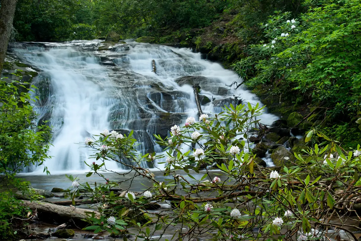
Tom Branch Falls — Starting back at the Deep Creek Trail Trailhead trailhead, walk just 1,000 feet along the wide, flat Deep Creek trail to Tom Branch Falls, a wispy waterfall that gently splashes over 80 feet into Deep Creek. A bench is provided beside the creek and is a great place to sit and watch the inner-tubers float by.
One of the great things about this trail is that it offers some immediate rewards. From the opening of the trail, you get to walk along side the rushing Deep Creek, and watch kids, adults and families tubing down Deep Creek, and having a blast. Just 3/10s of a mile up the trail, you’ll come to Tom Branch Falls, an 80 foot waterfall. Toms Branch Falls cascades down into Deep Creek on the opposite bank from the trail.
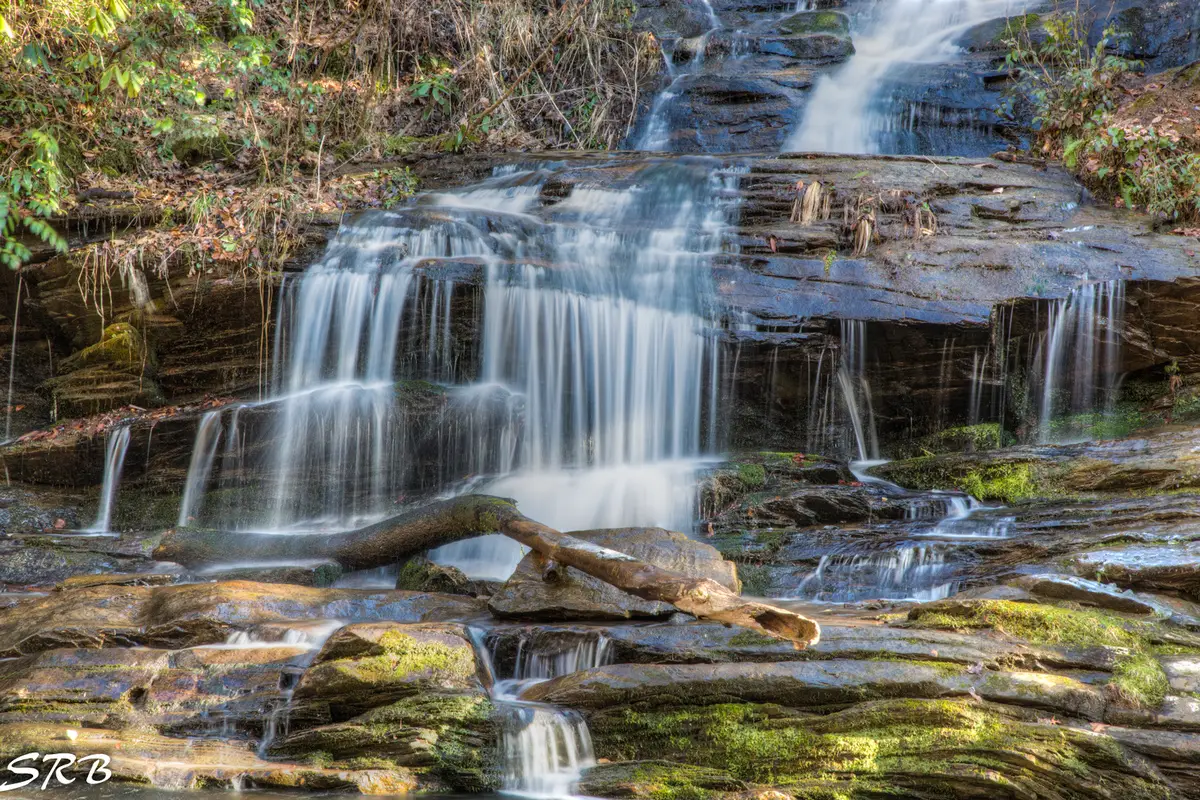
Continue along the Deep Creek Trail for approximately 1/3 of a mile past Tom Branch Falls to Indian Creek Falls that spills 25 ft. into a picturesque cove. The round-trip hike to see these two is 1.6 miles and easy.
There are two loop trails that take you to all three: Three Waterfalls Loop (2.4 miles) and Deep Creek-Indian Creek Loop (5 miles). See our Deep Creek Waterfalls Guide. See map below or download a PDF Map of these hiking trails.
Indian Falls by Timothy Widley
Indian Creek Falls — About a mile after leaving the Deep Creek Trailhead along the Deep Creek trail, the path goes up a slight slope to where Indian Creek flows into Deep Creek. Follow the Indian Creek Trail 200 feet uphill to the right to reach Indian Creek Falls, a loud waterfall that drops 25 feet into a pool. The bottom of the falls is reached by a short trail.
Deep Creek Hike Description
Along this trail, there are also a lot of wildflowers. As you walk towards Indian Creek Falls, you’ll see Cinquefoil, Crested Dwarf Iris, Galax, , Solomon’s Seal, Foamflower, Bluets, Bloodroot, and Blue-eyed grass, all of which bloom at different times during the spring. There are also a lot of Jack-in-the-pulpit plants, but they can be hard to find among the Wild Geranium, Large Houstonia and Clinton’s Lily.
At 0.8 miles after you leave the Deep Creek Trail Trailhead, hikers will reach the intersection with the Indian Creek Trail. To start the loop part of the hike, you should turn right on the Indian Creek Trail. After only a tenth of a mile of walking, there will be a short trail on your left that leads down to Indian Creek Falls. This 45-foot falls is really cool. As you climb back up to the main trail and pass above the falls, you may notice that Indian Creek Falls is more of a water slide than a real waterfall.
As you keep going around the loop of the hike, you will soon cross a footbridge. You may also notice that the Indian Creek valley, which is now on your right, is full of rhododendron along this part of the trail.
About 1.4 miles in, the Stone Pile Gap Trail splits off to the right. In less than a mile, it meets up with the Thomas Divide Trail. At this fork, hikers should keep going straight ahead.
At 1.7 miles, you’ll come to a junction with the Deep Creek Loop Trail. Hikers who want to keep going on the loop hike should turn left here. Before you reach the Sunkota Ridge Trail junction, you’ll climb about 350 feet over the next half mile. After you turn onto the Loop Trail, you’ll quickly leave the noise of Indian Creek behind. You’ll enter a much quieter valley, where the only sound you might hear is your own heavy breathing.
As you go up the trail, you’ll start to see mountain laurel, rhododendron, and flame azalea growing there.
When hikers get to the Sunkota Ridge junction, they should keep going straight to keep on the loop hike. From here on, it’s all downhill until you get back to Deep Creek. About 2.9 miles from the trailhead, when hikers reach the intersection with the Deep Creek Trail, they should turn left, cross the footbridge, and then follow the trail back to the parking lot. From this point on, the trail goes through mostly flat land.
At about 3.7 miles, hikers will reach a side trail that leads to Juney Whank Falls, a nice 80-foot cascade. This is on the way back to the parking lot. The spur goes about 1.2 miles to the falls and then another quarter mile back to the parking lot, if you’d rather take this alternative route back to the trailhead.
Hiking Tips For the Deep Creek Trail
Be bear aware! I was standing at the Deep Creek Trail Trailhead bulletin board, looking up the path and there is a black bear walking toward me!
Pack the 10 Essentials For the Deep Creek Trail
1. Navigation + Communication Devices Fully Charged
2. Sun Protection
3. Proper Footwear + Extra Clothes
4. Water
5. Extra Food
6. Headlamp
7. First Aid + Repair Kit
8. Knife / Multi-tool
9. Fire Tools
10. Emergency Shelter
11. Trash Bag
Directions To the Deep Creek Trailhead:
From Gatlinburg, take the main Parkway into the National Park. Keep track of how far you’ve gone when you pass the Sugarlands Visitor Center on your right. The National Park is 32.1 miles long. When you get to where Route 441 and Route 19 meet in Cherokee, turn right on Route 19 and go for 10 miles until you get to Bryson City.
Turn right on Everett and go 0.2 miles until you reach Bryson Street. Turn right onto Bryson Street and keep going for 0.2 miles. Take Ramseur Street, which is the third street on your left. Deep Creek Road is the second right you’ll come to. Follow Deep Creek Road for 2.8 miles until you reach the Deep Creek Trail Trailhead for the Deep Creek trail.(you will enter park 0.5 miles prior to arriving at the trailhead).
Review of the Deep Creek Trail
Since I moved here, I walk this trail often. This flat, easy trail is a very easy way to add 4 miles to our daily routine. Be careful, because Elk can sometimes be seen on this trail, especially in late summer and fall.
This trail is perfect for running! For practice, we would run it all the time. There aren’t many hills, and there are a lot of chances to see wildlife. At times, the trail looks out over Deep Creek. There aren’t a lot of interesting things to see, but it’s still worth the time to look around.
This is a great place to show your kids ant mounds (please don’t destroy them, since this is a refuge and everything here is protected) and to learn about ants and their colonies. There are birds everywhere, but you might have to stop to hear them over the sound of leaves and gravel crunching.
As some people have said, the signs make this very clear: it is NOT dog-friendly.
Deep Creek Trail Nearby Trails to Hike
Lonesome Pine Overview
This 6.6-mile trail near Bryson City, North Carolina, goes out and back. It takes an average of 4 hours and 20 minutes to finish what most people think of as a difficult route. This is a popular trail for walking and hiking, but there are still times of the day when you can be alone. From April to November is the best time to visit this trail. Dogs can’t go on this trail, so you’ll have to leave them at home.
Difficulty: A Challenge
Length: 6.6 mi
Elevation gain: 2,273 ft
Route type: Out & back
Walking, Forest, River, Views, Wildlife, No dogs
Review
Excellent trail! The whole way up is a steady slope, but there are no steps. Beautiful area with good places to stop and see the scenery. Was amazing to hike into snow flurries that started in the last mile of elevation. We went hiking on a Sunday and had the trail to ourselves.
Took 3.5 hours, with stops to take pictures along the way and a break at the top to enjoy the view. At the top, there are no signs of a copperhead nest. Now I want to hike all the way to Clingmans Dome on the Noland Divide Trail.
Goldmine Loop Trail
Find out about this loop trail that goes around 3 miles near Bryson City, North Carolina. Most people think of it as a moderately hard route, and it takes an average of 1 hour and 45 minutes to finish. This is a popular place to watch birds, hike, and ride horses, so you’re likely to run into other people while you’re exploring. From March to November is the best time to visit this trail. Dogs can’t go on this trail, so you’ll have to leave them at home.
Difficulty: Bit Challenging
Length: 3.0 mi
Elevation gain: 780 ft
Route type: Loop
Kid friendly, Hiking, Horseback riding, Road biking, Walking, Bird watching, Running, Forest, Lake, Views, Wildflowers, Wildlife, No dogs
Review
There are no real views to speak of. At the half-way point, you can see a small cove. If it had rained recently, there might be some muddy spots. Some boards are down in the worst spots, so you should be fine for the most part. It is next to a lake and creek and in an area with a lot of plants, so it will be very humid. The scenery is beautiful, and the road is great. Clear as a bell, and fish everywhere
If you go during the warmer months, make sure to wear bug spray. I put it on again a few times, but they were still coming at me. At the beginning, it goes downhill, and at the end, it goes uphill, which will get your heart rate up.
Tsali Mouse Branch Loop
Learn about this loop trail that goes around 8.2 miles near Bryson City, North Carolina. Most people think of it as a moderately hard route, and it takes an average of 3 hours and 15 minutes to finish. This trail is used by a lot of people to watch birds, hike, and ride horses, but you can still get some alone time during the day.
From March to October is the best time to visit this trail. We allow dogs, but they have to be on a leash.
Difficulty: Not That Difficult
Length: 8.2 mi
Elevation gain: 833 ft
Route type: Loop
Dogs on leash, Hiking, Horseback riding, Mountain biking, Bird watching, Forest, Views, Wildflowers
Review
Great hiking trail with beautiful views and lots of fall colors. The water level was a lot lower than the last time I was here, and some of the creeks were dry. I have to say, though, that I really enjoyed the hike in the fall and late summer. I wouldn’t go on it right after it has rained. Some parts of the trail are like small valleys.
The trail made for a pretty hard walk. Even though it had rained a lot recently, the trail was mostly clear and dry. Most muddy parts were no longer than 10 feet. I thought that the trail had just the right amount of ups, downs, and switchbacks. Plus, the view from the lookout was great. I did get a little lost when I got off the trail to the lookout. To finish the loop, I had to turn around and go back up the trail that led to the trail to the lookout. Overall, it’s a great trail that even an experienced hiker will find difficult.
Things to Do Near the Deep Creek Trail
The Tunnel To Nowhere
Bryson City, drive Everett Street from U.S. 19 past the depot
When you leave town, the road turns into Fontana Road. In just a few miles, you’ll see a sign for Great Smoky Mountains Park. This sign marks the beginning of the Road to Nowhere, which is officially called Lake View Road.
There is so much to see and do in the Bryson City area that it’s hard to think of a time when you’d have nothing to do. But if that happens, you can always take The Road to Nowhere, a beautiful mountain highway that goes six miles into the Great Smoky Mountains National Park and ends at the mouth of a tunnel. Lakeview Drive is what it’s called on the map, but the people of Swain County call it “The Road to Nowhere — A Broken Promise.”
Review
The Federal government said that a new road would be built in place of Highway 288. Lakeview Drive was supposed to go from Bryson City to Fontana, 30 miles to the west, along the north shore of Fontana Lake. And, for those people who had to leave their homes, it was especially important that they could still visit the old family cemeteries where generations of their ancestors were buried.
But Lakeview Drive was stopped from being built because it was bad for the environment. The road ended at a tunnel about six miles into the park. The cost of taking care of the environment was eventually deemed too high, and the roadwork was never done. The people of Swain County called the unfinished Lakeview Drive “The Road to Nowhere,” which is not an official name.
Mountain Layers Brewing Company
90 Everett Street, Bryson City, NC 28713
Review
Mountain Layers Brewing Company is an award winning, 7 barrel, craft microbrewery and taproom located on historic Everett Street in beautiful downtown Bryson City, Swain County – the gateway to the Great Smoky Mountain National Park in North Carolina.
Our brewery and taproom feature two bars: one on the main level built around the brewhouse and another upstairs where you can drink on the outdoor deck overlooking downtown. The dream of opening a brewery came after a 30 year career in public service so we are incorporating that background into this project through an Honor and Remember Wall – a tribute to our military veterans and country’s first responders.
Nantahala Gorge Ruby Mine
11900 US Hwy. 19/74 West in Bryson City, NC 28713
Review
A favorite thing for both adults and children to do in the area. On-site professional gem stone advice is available. We can work in any weather because our sluice is covered. No entrance fee. Gene Elliott, our gemologist, can evaluate and cut gem stones right here on the premises. Gene has been praised locally and nationally for being honest, fair, and good at his job.
If my girlfriend hadn’t insisted, I would have never stopped here, but I ended up having a great time and spending a lot of money on big buckets of dirt that we sifted through to find precious and semiprecious stones! We found a lot of emeralds and rubies, but most of them weren’t good enough to cut. We still had a great time, though. A family of the nicest people runs this gem mine. We’ll go again and again!
Food and Diner Locations Near the Deep Creek Trail
Jimmy Mac’s Restaurant
121 Main St, Bryson City, NC 28713
Review
My wife and I were heading to the Dragon and discovered this place! We had a great visit with the new owners and thoroughly enjoyed our lunch….Philly Cheese Steak Sandwich and Jalapeno Pulled Pork Nachos! We HIGHLY recommend you try them out…You’ll love it! They’re now on our “We Gotta’ Go Back!” List….. Also, most importantly: The Dragon Pitt Inn and BBQ is under NEW OWNERSHIP since June of 2022 and these folks REALLY care about good food and quality service!
Everett Street Diner
126 Everett St Bryson City, NC 28713
Review
I felt at home and well cared for, from the host explaining the wait, the person serving my coffee and the person taking our orders. I want to stress how important this is since lately service quality is written off as “no one wants to work, or it’s COVID’s fault”.
This service was top knotch. The food-everything was perfectly cooked and seasoned. Order anything, I think you will be happy. Also the restaurant itself was not packed with tables on top of each other making it COVID friendly.
The atmosphere – pure southern hospitality. Will we be back? You betchya.
Bar-B-Que Wagon
610 Main St Bryson City, NC 28713
Review
IMO many of the slightly-less-than-great reviews here take the model of “this place isn’t exactly like the bbq place down the road from my grandma when I was a kid, and therefore I will not rate it highly.” Yeah, this place isn’t exactly like that place for me either, but it doesn’t have to be for it to be excellent.
Had the chopped pork one day, with great fries and baked beans. Lots of sauce options to choose from. The vinegar, gold, and spicy options were my favorites, alone or mixed together. Two days later I thought I’d try the beef, so I got some brisket which was also great, with mashed potatoes and fried okra.
My only complaint is that the fried okra was maybe a little overcooked. Friendly service, decent prices, fun interesting random stuff to look at on the wall while you’re eating. Two thumbs up.
You May Want to Join Our Boondocking Group on Facebook For More Information
You May Want to Join Our Campfire Recipes Group on Facebook For More Information