

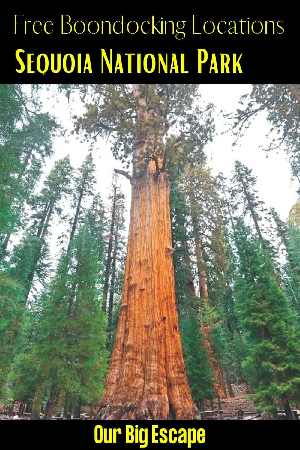
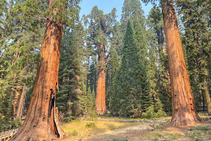
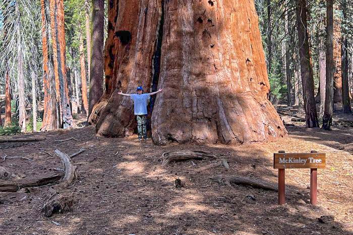
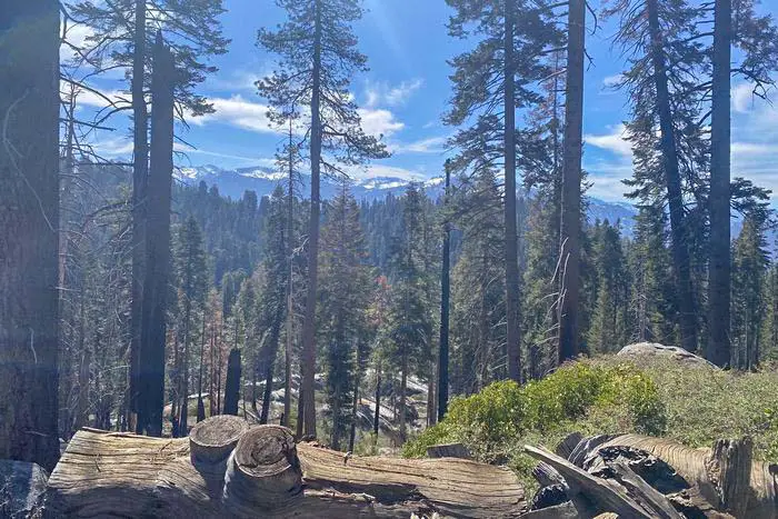
The Sequoia National Monument is Giant Sequoia Conservation Area, which contains approximately half of the world’s giant sequoia groves, protects the Sequoia National Forest. While these trees (also known as “Sierra redwoods,” Sequoiadendron giganteum) do not grow to the same height as coastal redwoods, they are larger in volume. They can reach a height of 270 feet and a diameter of 30 feet here.
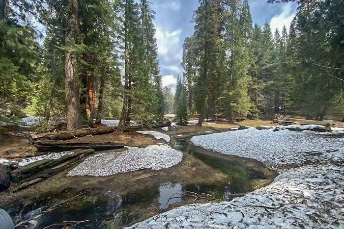
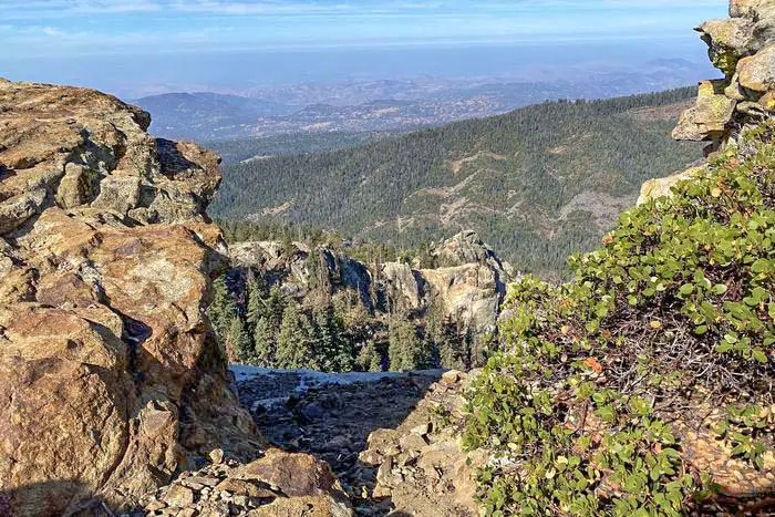
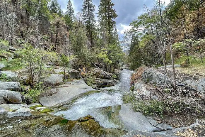
The 328,000-acre Monument includes many more features, including granite peaks, flowing rivers, and flower in the many green meadows, with elevations ranging from 2,000 to 10,000 feet. Archaeological finds in this part of the Sierra Nevada demonstrate the 8,000-year history of tribal groups through Native American village sites, rock shelters, artifacts, and engravings.
The Monument is separated into two sections, each of which is geographically distinct. One section is located just east of Fresno, north of Sequoia National Forest. The majority of it is located south of the park and east of Porterville.
Want more ideas to round-out your trip to California?
A lot of great ideas are in these posts!
- 6 Top Pinnacles National Park Boondocking Locations
- 14 Redwood National Park Boondocking (Updated 2022)
- 18 Kings Canyon National Park Boondocking (Updated 2022)
- 15 Yosemite National Park Camping Spots (Updated 2022)
- 5 Death Valley Salt Flats Boondocking (Updated 2022)
- 419 Awesome California Boondocking Campsites And Maps
- Our Top 25 Yosemite Hikes For All Ages
- 5 Best Hiking Trail Bonita Falls Photos Hot Spots
- 8 Places to Visit in Sequoia National Park
Looking for the best high-altitude mountain trails or the lush forest then the Sequoia National Monument has virtually everything you want in a boondocking spot. I’ve spent my memorable birthday and Labour Day celebrations hiking through at the Sequoia National Monument. On the two occasions I enjoyed the breathtaking views of sequoias and the vistas.
My visit to the Sequoia National Monument was truly a tremendous experience that made me love and appreciates nature. I feel like going back to the same place with gorgeous trees, happy wildlife and welcoming tour guides. Before I plan for my subsequent visit, let me first take you through some facts that you need to know about the Sequoia National Monument. We might meet there for a great time.
The Sequoia National Monument is the treasure of all beauties that is worth your exploration. It showcases unique giant sequoia grooves called Sierra redwoods. The trees at the Sequoia National Monument are big and grow to a diameter up to 30 feet and 270 feet high. The monument is divided into two geographical areas, which include the northern and southern parts.
History of the Sequoia National Monument
The Sequoia National Monument was first designated in April 2000 by William Jefferson Clinton. It covers an area of approximately 328,315 acres. The fascinating thing about the Sequoia National Monument is its prestigious giant sequoia, dubbed as the largest tree in the world. The tress at the Sequoia Monument grow naturally as a mixture with the Conifers at the Sierra Nevada mountain range in California.
At the Northern Portion of Sequoia National Monument, there are 13 groves located east of Fresno. The nearby Kings Canyon and Sequoia parks also manage the sequoias groves. The Southern Portion of Sequoia National Monument has 20 giant sequoia groves east of Porterville and Springville, California. The Sequoia National Monument is a public treasure located in the southern Sierra Nevada. It offers diverse human history, geological formations and ecosystem. After visiting the giant monument, I benefited from limitless recreational activities, public education, and the great reveal from scientific studies.
It’s believed that the Sequoia trees in the Sequoia National Monument are not merely big and old trees. However, they are thought to symbolize wisdom, endurance, forgiveness, strength and gratefulness. Places and Things to Do and See in Sequoia National Monument
14 Boondocking Locations for Sequoia National Monument
check out our video
1. Free Sequoia National Monument Boondocking – Stine Cove
Address
6651 Sierra Way
Kernville, California
GPS: 35.679037, -118.409049
Elevation: 2602′
Management Public: Forest Service
Stine Cove is open all year. This is a free dispersed campsite. No reservations. First come, first served. Stine Cove is open all year.
Amenities:
Restrooms
Best Review:
Nice area right on Lake Isabella. No shade and a little road noise. Vault toilet. We were the only ones camping. A few people came to fish and walk the beach. You will need a fire permit for cooking on charcoal, gas and for fire pit.

2. Free Sequoia National Monument Boondocking Locations – Lake Isabella Auxiliary Dam
Address
Lake Isabella, California
GPS: 35.647419, -118.459483
Elevation: 2579′
Management Public: Bureau of Land Management
Lake Isabella Auxiliary Dam is open all year. This is a free dispersed campsite. No reservations. First come, first served at Lake Isabella Auxiliary Dam.
Best Review:
Wanted to share this spot. We stayed 5 nights and left to do a trade show over the weekend and returned for 5 more nights. Really enjoyed our stay. Seems to crowd up on the weekends by the amount of camper coming in on Friday evening. But, easy to spread out and not be too close to others. It’s about an hour east of Bakersfield, CA and a pretty drive. A ranger drove through and asked each camper how long they’ve been there. He was very nice. The primitive bathroom is close for the winter. Dumpsters are available. The city of Lake Isabella is close by for supplies.
3. Free Sequoia National Monument Camping Spots – Keyesville SRMA
Address
Lake Isabella, California
GPS: 35.641125, -118.48391
Elevation: 2480′
Management Public: Bureau of Land Management
Fire Ring
Near Water
Picnic Tables
Restrooms
Best Review:
A hidden gem near Lake Isabella. Camped here in mid December 2021 and there was only one other camper. Beautiful running Kern River. Some spots may require 4 wheel drive. cwrandom would camp here again.
4. Free Sequoia National Monument RV Parking – BLM Kern River North
Address
Mountain Mesa, California
GPS: 35.630346, -118.499336
Elevation: 2589′
Management Public: Bureau of Land Management
This is a free dispersed campsite. No reservations. First come, first served at BLM Kern River North.
Best Review:
I stayed in BLM lands off of Route 155 West of Lake Isabella in California. You will see the north side of the Kern River. This paved road takes you into several pull out spots.
5. Sequoia National Monument Hiking – Evans Flat
Address
Forest Route 25S15
Bakersfield, California
GPS: 35.642809, -118.58945
Elevation: 6079′
Management Public: Forest Service
Amenities:
Restrooms
Best Review:
We tried driving up to Evans 4/23/22 but we were slipping in mud, and eventually got stuck, luckily we were helped out by a group with 4WD (thank you again) so we were able to make it back down in time to look for another campsite before it got dark. If you’re looking to camping here, be cautious of the road w/o 4WD, and go after wet/snow season because the road gets extremely muddy, there’s also no cell service up there. Id like to try to visit this site again but not anytime soon, happy camping everyone!
6. Free Sequoia National Monument Boondocking – Alder Creek (Alta Sierra)
Address
Forest Route 25S04
California
GPS: 35.719841, -118.611855
Elevation: 3888′
Management Public: Forest Service
The maximum RV length at Alder Creek (Alta Sierra) is 20 feet. 11 miles east of Glennville via State Highway 155 and Alder Creek Road (25S04). Paved and dirt road; no water; fishing seasonal. Maximum RV length 20 feet.
Amenities
Restrooms
Best Review:
The campsite is pleasant. Small creeks on both sides. Tall trees but still lots of sunlight available. Probably 10 different cleared out sites, with a good distance between all of them. We stayed at the first one, because there was a spot in the road right after it that I didn’t want to subject the camper to. Several fire rings with stumps or rocks to sit on. Many of the other sites also had steep grades to get to off the main road–probably only 3 or 4 are accessible without 4×4 (but if you’re tent camping, obviously, you don’t need to drive down there to use it).
7. Free Sequoia National Monument Boondocking Locations – Dispersed Campsite – Evans Road
Address
Glennville, California
GPS: 35.744483, -118.596544
Elevation: 4872′
Management Public: Forest Service
The road in is Dirt and .1 miles from a paved road. Dispersed Campsite – Evans Road – Sequoia National Forest is open weather permitted. There are 1-5 campsites at this location. You may stay 14 days at Dispersed Campsite – Evans Road – Sequoia National Forest.
Best Review:
None
8. Free Sequoia National Monument Camping Spots – Calkins Flat
Address
1941 Kern River Highway
Kernville, California
GPS: 35.918243, -118.490873
Elevation: 3504′
Management Public: Forest Service
Free Dispersed camping in the Sequoia National Forest’s Kern River Ranger District. First come -> first camped. No reservations are accepted.
Amenities:
Restrooms
Best Review:
None
9. Free Sequoia National Monument RV Parking – Cedar Creek
Address
Evans Road
Wofford Heights, California
GPS: 35.74902, -118.582742
Elevation: 4892′
Management Public: Forest Service
Amenities:
Restrooms
Best Review:
Tried to get to this site today, but had to turn around 5 miles up the road because snow chains are required! Good to note for winter campers!
10. Sequoia National Monument Hiking – Multiple Dispersed Sites
Address
Wofford Heights, California
GPS: 35.747751, -118.560942
Elevation: 5577′
Management Public: Forest Service
Multiple Dispersed sites on forest service land. There is an old unmaintained dirt road that comes off the main road. Immediately there is one little site, that could fit a 20′ camper
Best Review:
Dispersed camped here on 5-23-2022 and the area was significantly impacted by the French Wildfire. Most if not all trees are severely burned and unsafe to camp around. The east side of the site is completely burned down. Ash covers the ground in about 6 inches deep throughout the forest.
11. Free Sequoia National Monument Boondocking – Panorama
Address
Forest Route 23S16
Posey, California
GPS: 35.808549, -118.571461
Elevation: 7349′
Management Public: Forest Service
Panorama is open Jun-Oct. This free campsite is located within the Sequoia National Forest’s Western Divide Ranger District. This is a high elevation location.
Amenities:
Restrooms
Best Review:
None
12. Free Sequoia National Monument Boondocking Locations – Chico Flat Campground
Address
Mountain Road 99
Kernville, California
GPS: 35.8235, -118.462
Elevation: 2935′
Management Public: Forest Service
Restrooms
Trash Cans
Best Review:
Chico Flat Campground is open year round. Free dispersed camping on Upper Kern River in the Sequoia National Forest. Camping and campfires (fire permit required) within 25 feet of the water’s edge is prohibited due to the Wild and Scenic Designation. There is no water available at this location. Portable toilets and trash receptacles are available during summer months. Campfire permits required for campfires, barbecues, and camp stoves.
13. Free Sequoia National Monument Camping Spots – Frog Meadow
Address
Forest Route 24S50
California Hot Springs, California
GPS: 35.874131, -118.575252
Elevation: 7582′
Management Public: Forest Service
Frog Meadow is open Jun-Oct. The maximum RV length at Frog Meadow is 16 feet.
Amenities:
Restrooms
Best Review:
The cabin is great, but this site is about camping, so I wanted to tell you about the sites. There are fire rings, tables, and a pit toilet. There is no water, but if you asked nicely, the people staying at the cabin might let you fill up a water jug outside from a hose bib. Frog Meadow is beautiful and lots of forest roads and trails around. One trail begins at the campground and starts to head down the mountain beside a creek.
14. Free Sequoia National Monument RV Parking – Ant Canyon Dispersed Camping – Upper Kern River
Address
Kern River Rd / Mountain Hwy 99
Kernville, California
GPS: 35.88595, -118.45757
Elevation: 3274′
Management Public: Forest Service
The road in is Paved. You may stay 14 Nights at Ant Canyon Dispersed Camping – Upper Kern River – Sequoia National Forest. Dispersed camping along the Upper Kern River. Multiple sites along the Kern River Rd / Mountain Highway 99. Fishing, boating and hiking are popular activities in the area.
Best Review:
Be on the lookout for signs or you will miss this beautiful serene dispersed camping area. I believe it’s the furthest north site in a curve, but use the last entrance(its not as rough) especially if you’re in an RV. that way you’ll be turned around to head back down 99. beautiful views and the sounds of the river will lull you into a peaceful sleep at night!
Top 10 Trails to Hike at Sequoia National Monument
Sequoia National Forest preserves 1.2 million acres of the Sierra. Within the national forest there are 328,000 acres and 33 giant sequoia groves that receive extra protection as part of Giant Sequoia National Monument.
Sequoia National Forest is split into three ranger districts. The southernmost district is the Kern River District, followed by the Western Divide Ranger District, which borders Sequoia National Park to the north and is the largest piece of the Giant Sequoia National Monument.
Sequoia National Monument Hiking #1. General Sherman Tree Trail
My hike through General Sherman Tree Trail was amazing. It gave me great views of the trees and forest. Furthermore, I found myself running deep into the beautiful nature complemented by small waterfalls through the congress trail.
When going through the General Sherman Tree Trail, be sure to wear good shoes, carry drinking water and take as many breaks as you need at the benches to refine your energy. The elevation of General Sherman Trail is 7,000 ft. above the ground. Therefore, you’ll get to see a lot of wildlife without straining.
The paved General Sherman trail led me to General Sherman area, where I found the world’s largest tree. I found a lot of interpretive panels along the General Sherman trail to teach me more about sequoias ecology and even the General Sherman Tree.
Length: 1.2 mi
Elevation gain: 196 ft
Route type: Out & back
Kid friendly, Hiking, Walking, Forest, Partially paved, Views, Wildflowers, Wildlife, Fee, No dogs
Sequoia National Monument Hiking #2. Big Trees Trail
Big Trees Trail offers a wonderful and relaxing experience. It was perfect for beginners like me because it’s completely paved and well-maintained. Stopovers at the beautiful sequoias and meadow are worth it. During my visits is found the nearby gift shop open while the visitors center was closed.
The Big Trees Trail is short, but there is much for you to see. Nature is impressive, and the terrain is easy to climb. As a result, you don’t need special shoes for hiking Big Trees Trail. There is a large meadow around the loop to give a good space for wildlife photography.
Length: 1.3 mi
Elevation gain: 114 ft
Route type: Loop
Wheelchair friendly, Kid friendly, Stroller friendly, Hiking, Walking, Bird watching, Forest, Paved, Views, Wildflowers, Wildlife, Fee, No dogs
Sequoia National Monument Hiking #3. Congress Trail
Walking through the Congress Trail was an enjoyable and memorable experience. It’s shaded, and the hike was really cool. I was not expecting much from it, but it gave me a smooth transition from General Sherman. Unfortunately, the larger route has some fog.
Congress Trail is connected to a significant number of trees like the Senate. Longer trails bring you back to the Giant Forest Monument. I managed to see a marmot from the Congress trail. Again, be keen on the trail makers, the map and the signs nailed on the tress.
Generally, I recommend that you take a turn away from the main Congress Trail and explore the magnificent surroundings. Please don’t get Lost. That is possible because there are a lot of magical views that can lure you away from what you understand as reality.
Length: 3.0 mi
Elevation gain: 495 ft
Route type: Loop
Kid friendly, Hiking, Snowshoeing, Walking, Bird watching, Forest, Paved, Views, Wildlife, Fee, No dogs
Sequoia National Monument Hiking #4. Congress-Trail of the Sequoias-Tharp’s Log-Congress Loop
To expand your visits to Sequoia National Monument further, you need a hike from the Sherman Tree Trail to Congress Trail that ends in the Trail of Sequoias. The three connections form a loop.
Throughout the Congress-Trail of the Sequoias, be prepared to have an awe of massive wonders. It would help if you were keen on this trail because it’s particularly not paved, especially from the President’s tree to the Sherman Tree. Of all the hikes in Sequoia National Museums, Tharp’s Log-Congress Loop was one of my favourites.
Length: 7.0 mi
Elevation gain: 1,272 ft
Route type: Loop
Kid friendly, Hiking, Bird watching, Running, Forest, Partially paved, Views, Wildflowers, Wildlife, Fee, No dogs
Sequoia National Monument Hiking #5. Moro Rock Trail
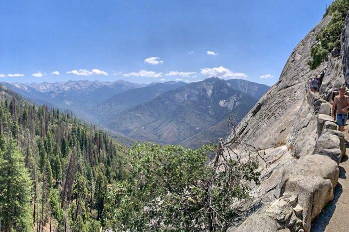
Moro Rock was a great climb for me because of the wonderfully set rocks. I still recall a lot of amazing views of this area. The staircase of the Moro Rock Trail leads to the wonderfully staged viewpoint for the bigger part of Sequoia National Monument. It might be hard climb for some individuals, but it’s worth it.
In fact, from my side, I promise myself to do a hike through the Moro Rock Trail next time I’m in Sequoia National Monument. The full panorama of Moro Rock is breathtaking in both intensity and beauty.
The 400-staircase climb is the most challenging elevation that consumes more of your time. Moro Rock Trail involves a strenuous climb. Therefore you need to hike through it when the air quality is healthy and the lightning strikes are less likely to happen.
Length: 0.5 mi
Elevation gain: 177 ft
Route type: Out & back
Kid friendly, Hiking, Forest, Views, Wildlife, RockyFee, No dogs
Sequoia National Monument Hiking #6. Crystal Cave Trail (Closed Fire Damage 2022 – Hopefully Open 2023)
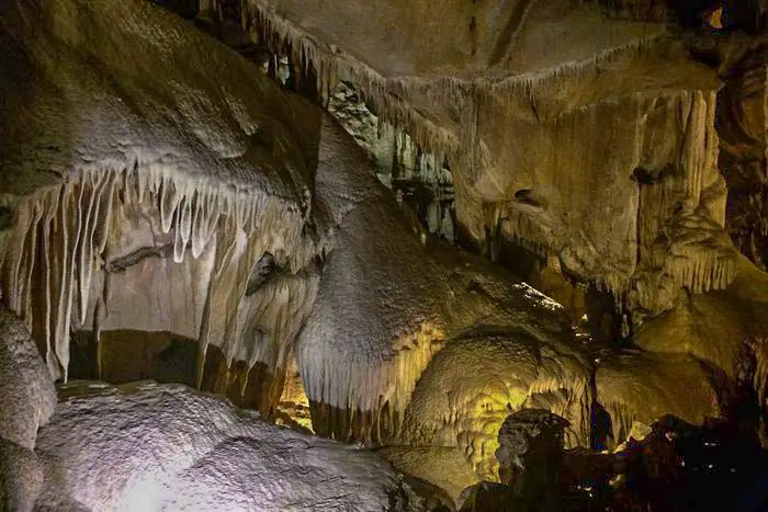
I used Crystal Cave Trail on Labor Day, and the walk was filled with multiple waterfalls and impressive valley views. The tour guide told me that at a given moment when you hike the Crystal Trail in the right session of the Year, you would get to see the beautiful wildflowers. The best moment of hiking through the Crystal Cave Trail is between May and November.
Crystal Cave Trail is partially paved, and it’s primarily used for walking. The 1.3-kilometre stretch leads to a beautiful cave called the Crystal cave. We walked through the Crystal Cave Trail with my friends, and it was super interaction that we all enjoyed. More so with the knowledgeable and friendly guides.
Length: 0.8 mi
Elevation gain: 291 ft
Route type: Out & back
Kid friendly, Hiking, Walking, Cave, Forest, Partially paved, River, Waterfall, Fee, No dogs
Sequoia National Monument Hiking #7. Tokopah Valley Trail
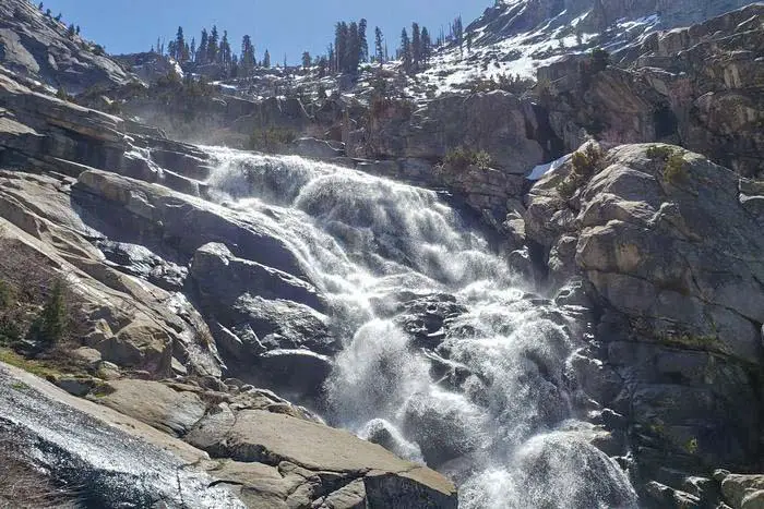
The Tokopah Valley Trail has heavy traffic in the entire Sequoia National Monument. However, it’s well-maintained and controlled to improve human safety. I loved it because the 600-foot elevation is never stepped and challenging to climb.
Tokopah Valley Trail follows through the Marble rock and waves through Tokopah Valley. As I was walking through it, the sound of running water for River Kawaeah was my constant companion.
As you hike through the Tokopah Valley Trail, you’ll have to pass through other small streams, including Horse Creek. They provide the perfect opportunities for you to cool off from hot weather.
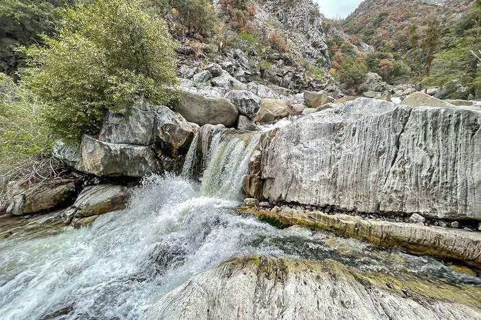
Ultimately, I can’t finish talking about the Tokopah Valley Trail without stating the stunning views from the 3,973 feet granite monolith. Tokopah Falls is the tallest fall in Sequoia National Monument, and it’s visible throughout the Tokopah Valley Trail. Sadly the falls only flow seasonally. During drought conditions, there is nothing much you can see.
Length: 4.0 mi
Elevation gain: 639 ft
Route type: Out & back
Kid friendly, Sequoia National Monument Camping, Hiking, Walking, Bird watching, Running, Forest, Partially paved, RiverViews, Waterfall, Wildflowers, Wildlife, Fee, No dogs
Sequoia National Monument Hiking #8. Big Baldy Ridge Trailhead
The Big Baldy Ridge Trailhead is a nice and lovely trail taking you to the ridge for amazing views. Going through it, you will get to see the wildflowers if the season is right. It’s moderately difficult to climb. Therefore it might be a bit challenging for you to manage it with kids or the elderly. The weather of Big Baldy Ridge Trailhead is also too much hot. Therefore, you need to carry water for your cooling.
Length: 6.4 mi
Elevation gain: 1,423 ft
Route type: Out & back
Sequoia National Monument Camping, Hiking, Bird watching, Forest, Views, Wildflowers, Wildlife, Fee, No dogs
Sequoia National Monument Hiking #9. Ladybug Camp Trail
I found the Ladybug Camp Trail as the best trail with marvellous diversity. The nearby forest is filled with tall and brown trees. I enjoyed the diversity of Ladybug Camp Trail, and as I was hiking through it, I could see the vast Sequoia tress well fixed to the ground.
Notably, due to the wildfires of 2020, a significant portion of Ladybug Camp Trail was burned down. Therefore, you need to be cautious when hiking through it. However, the area is still the best for trail running, backpacking, families, camping and mountain biking.
Length: 7.2 mi
Elevation gain: 1,952 ft
Route type: Out & back
Kid friendly, Sequoia National Monument Backpacking, Sequoia National Monument Camping, Hiking, Mountain biking, Walking, Bird watching, Running, Forest, River, Views, Wildflowers, Wildlife, Fee, No dogs
Sequoia National Monument Hiking #10. Marble Falls Trailhead
I decided to go through Marble Falls Trailhead as early as 8:30. It’s among the long trails in Sequoia National Monument. I was the fast one from my group to set foot into the trail. After an hour or so into the hike, I felt like I was draining many fluids. It was a bit challenging to climb Marble Falls Trailhead. However, within 2 hours 15 minutes, I was at Marble Falls enjoying the beautiful scenery.
Marble Falls Trailhead is not recommended for beginners because the journey is tough, and they can easily give up. After enjoying the Marble Falls for 30 minutes, it was back down to end the hike. I remember how I was advised to prepare for a strenuous climb of Marble Falls Trailhead, and it turned out to be exactly as anticipated.
I won’t recommend you to go for the Marble Falls Trailhead hike in summer. It’s very challenging to find a shed, and the temperatures can go even beyond 100 degrees. If you insist on hiking through the Marble Falls Trailhead, do it very early in the morning.
Alternatively, the best time to hike the Marble Falls is February or March. The recreational activates that reign most at Marble Falls Trailhead include trail running, wildflowers sightseeing and walking.
Length: 7.4 mi
Elevation gain: 1,627 ft
Route type: Out & back
Sequoia National Monument Camping, Sequoia National Monument Hiking, Walking, Bird watching, Running, Forest, River, Views, Waterfall, Wildflowers, Wildlife, Fee, No dogs
Five places You Shouldn’t Miss on Your First Visit to Sequoia National Monument.
Ranging from the vast and enormous to dreamy views. The epic hikes at Sequoia National Monument make it an absolute destination that you need to explore sometime in your lifetime.
I was speeches when I first entered the monument. I had never seen and an amazing giant monument like that before. Everything described below carries ultimate satisfaction. You can’t afford to miss any of the five places stated below and the great reactional activities as you visit Sequoia National Monument. Don’t pocket your eyes; you will see great things as you move around.
1. General Sherman
General Sherman is where you will find the largest tree in the world. Holy molly, it’s even bigger than an aeroplane! Hiking to General Sherman made me believe a lot from sheer curiosity.
As I visit General Sherman, I was accompanied by other people who wanted to learn from the Sequoia National Monument. I noted that you need to stay on the trail and avoid jumping over the fence since that damages the shallow root system of the trees and the sensitive soil.
2. Climb the Moro Rock
The Moro Rock offers an epic view of the entire Sequoia National Monument during sunset. I was made to go through over 350 straight stairs upwards. The climb was easy. The distance taken to climb Moro Rock is short. Therefore, it didn’t take me too long before I was at the peak.
When you climb the Moro Rock, you get to enjoy the spectacular views of the Canyon that lies below. During my first visit, I realised that trail to Moro Rock was quite crowded. Another important thing is that you can view the site from the highway and the directions are clear.
3. Drive through the Sequoia National Monument Tunnel Log
Please visit here for me because I didn’t manage to explore it wholly because then I had a tall van that couldn’t go through the tunnel log. I’m sure you will enjoy the experience and even think of doing it again in the future.
At the Sequoia National Monument Tunnel Log, I only managed to get inside for a short walk, and I realised that driving through it brings a natural feeling that is more pronounced than what you experience when you travel through an artificial tunnel.
4. The Big Trees Loop
The Big Trees Loop is the place that made me feel a little bit tiny. One of the great aspects is how I felt so small to disappear inside the loop. The 1.3 miles hike through the trees loop brings a leisurely stroll with an alluring view of the towering sequoia trees plus the gorgeous wildflower meadows.
5. Explore the Crystal Cave
As I walked around the Sequoia National Monument, I found the marble cave that offers sweeping views of the monument under the giant sequoias. It’s pretty neat, and tour guides help you explore the underground loop between May and September. I had to have a heavy jacket, and I will still recommend the same for you if you explore Crystal Cave because of the low temperatures.
Things to Do: Camping, Fishing, Responsible recreation, Hiking, Hunting, Wildlife photography, Mountain biking
What to see: Beauty and peacefulness of the sequoia forest, Caves, Trees, Mines, Ticks, Marmots
You May Want to Join Our Boondocking Group on Facebook For More Information
You May Want to Join Our Campfire Recipes Group on Facebook For More Information