Kings Canyon National Park is open, summer, spring, and fall. It’s one of the best places I had the chance to visit. Most of the places in the park are open for visitors.
You will get to enjoy the great weather and incredible vistas. When you are at the park, you also can visit Sequoia National Park as there is a road joining the two. I was able to navigate through it quickly and could choose one boondocking spot to include Sequoia & Kings Canyon National Park.
- 18 Free Devils Postpile National Monument Boondocking Locations
- 15 Great Berryessa Snow Mountain National Monument Boondocking Locations
- 20 Free Sequoia National Park RV & Camping Locations
- 14 Castle Mountains National Monument Boondocking Locations
- 23 Best Boondocking Spots Near Death Valley National Park
- 27 Top Joshua Tree National Park Boondocking Spots
- 14 Free Sequoia National Monument Boondocking Locations
- 15 Great Lake Tahoe Boondocking Locations (Updated 2022)
If you are wondering whether you should visit this park, then the answer is yes. I highly recommend it because of the many things to enjoy there including the deep valleys and the skyscraping trees. There are also rock outcroppings that are very distinctive and not forgetting the serene environment. T
his place is a must-visit for anyone that enjoys the outdoors. Make sure you make a reservation before you go so that you are well prepared and have all the essential information.
History of Kings Canyon National Park
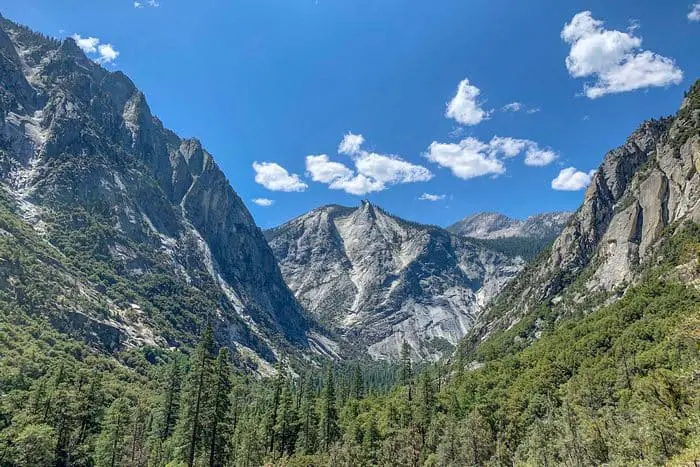
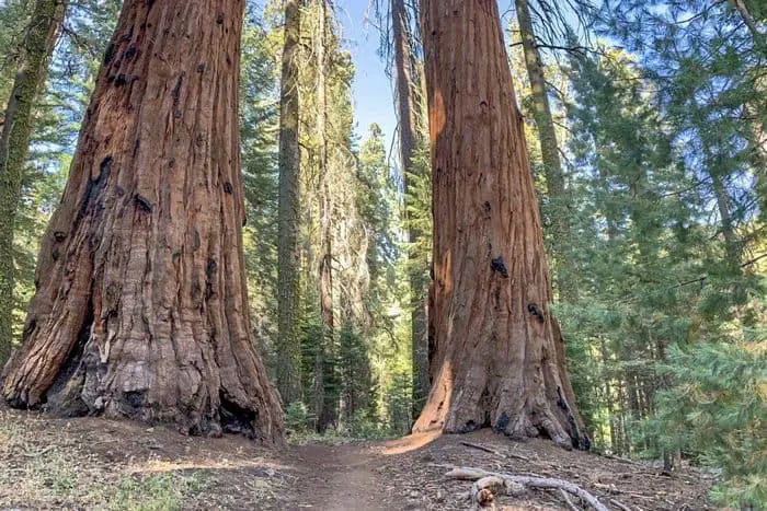
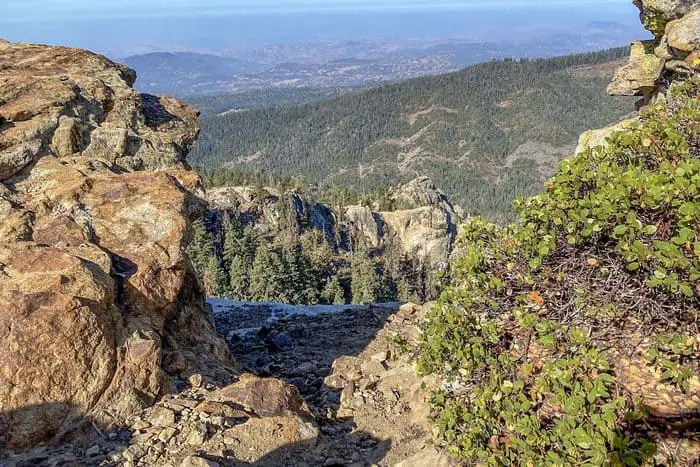
Kings Canyon National Park is a fantastic scenic area located at the Sierra Nevada Mountains in East-Central California. It was initially established in 1890 and named General Grant National Park. The park was expanded and then given the name Kings Canyon National Park on March 4 the year 1940. It is adjacent to Sequoia National Park, and the two parks are under the same administration. The park covers 722 square miles, and just like the other parks surrounding it, it also has big groves of trees. The trees include Cedar and Sequoias.
This park got its name from the Kings Canyon feature on the South Fork Kings River and was carved by glacial action. The Kings Canyon National Park is also well known for its magnificent trails. If you get to visit the park and you love hiking, then you should try out some of the ones listed below.

18 Free Kings Canyon National Park Boondocking Locations
check out our video
1. Free Kings Canyon National Park Boondocking – Kirch Flat Campground – Sierra National Forest
Address
Clovis, California
GPS: 36.882134, -119.149674
Elevation: 1026′
Management: National Forest Service
The road into this Kings Canyon National Park boondocking site is Paved. Kirch Flat Campground – Sierra National Forest is open Year Round. There are 16-29 campsites at this location and the maximum RV length is 30′. You may stay 14 Nights at Kirch Flat Campground – Sierra National Forest.
Amenities:
Fire Ring
Near Water
Picnic Tables
Restrooms
Best Review:
I stayed at this camp at the beginning of November, really nice place if you trying to escape from people, traffic and daily routine. There’s no phone service at all, almost 1hr and 20 min from 99 get, too many curbs on the road. We saw some deer hunters staying at the campground but most of the time was really quite.

2. Free Kings Canyon National Park Camping Spots – North Fork Confluence
Address
Fresno, California
GPS: 36.873207, -119.134056
Elevation: 975′
Management: National Forest Service
Free Kings Canyon National Park free campsites area at the confluence of the North Fork Kings River and Kings River. Fishing, camping and whitewater rafting are popular in this area. You may stay 14 Nights at North Fork Confluence.
Best Review:
None
3. Free Kings Canyon National Park Boondocking Locations – Camp 4 1/2 – Sequoia National Forest
Address
Clovis, California
GPS: 36.865379, -119.122551
Elevation: 1379′
Management: National Forest Service
The road into this Kings Canyon National Park boondocking site is Dirt and 0.7 miles from a paved road. Camp 4 1/2 – Sequoia National Forest is open Year Round. There are 1-5 campsites at this location and the maximum RV length is 25′. You may stay 14 Nights at Camp 4 1/2 – Sequoia National Forest.
Amenities:
Fire Ring
Near Water
Picnic Tables
Restrooms
Best Review:
Drive along north side of river is long, then cross over for the last few miles. Last 1/2 mile scoots up the side of the hill. Maybe okay for RV. At the campground, RV would have to park on open grass area “across the dirt road” from the campground. Putting a 25′ RV into a camp site might be physically possible (maybe), but it would totally dominate the entire 5-site campground.
4. Free Kings Canyon National Park Camping Spots – Gravel Flat Campground – Sierra National Forest
Address
Clovis, California
GPS: 36.86049, -119.11884
Elevation: 1278′
Management: National Forest Service
The road into this Kings Canyon National Park boondocking site is Dirt and 1 miles from a paved road. Gravel Flat Campground – Sierra National Forest is open Year Round. There are 1-5 campsites at this location and the maximum RV length is 25′. You may stay 14 Nights at Gravel Flat Campground – Sierra
Amenities:
Fire Ring
Near Water
Picnic Tables
Restrooms
Best Review:
Small campsite just off to the side of the large Gravel Flat campground. Great spot when the river is high. Shade, table, space for a campfire and on a calmer spot for swimming and fishing. But the fishing is tough here just FYI
5. Free Kings Canyon National Park RV Parking – Pirate Cove – Sequoia National Forest
Address
Clovis, California
GPS: 36.859112, -119.104172
Elevation: 1080′
Management: National Forest Service
The road into this Kings Canyon National Park boondocking site is Dirt and 2 miles from a paved road. Pirate Cove – Sequoia National Forest is open Year Round. You may stay 14 Nights at Pirate Cove – Sequoia National Forest.
Best Review:
Very nice place near a noisy mountain river. We stayed there for a weekends. Lots of space for tents. Campfire is permitted only in special areas. Three campsites with campfire circles and tables. One nasty toilet. The river a bit dangerous for swimming but in the next Mill Creek camp there is a beautiful little beach from a fairy tale.
6. Free Kings Canyon National Park Boondocking – Mill Flat Campground
Address
GPS: 36.8592, -119.096802
Management: National Forest Service
The road into this Kings Canyon National Park boondocking site is Dirt and 3 miles from a paved road. Mill Flat Campground is open Year Round. There are 1-5 campsites at this location and the maximum RV length is 25′. You may stay 14 Nights at Mill Flat Campground.
Best Review:
None
7. Free Kings Canyon National Park Boondocking Locations – Bear Wallow Camping Area
Address
Garnet Dike
Shaver Lake, California
GPS: 36.85758, -119.09101
Elevation: 1089′
Management: National Forest Service
Free this Kings Canyon National Park free campsites area near the Bear Wallow Camping Area is open year round. There are 1-5 campsites at this location and the maximum RV length is 25 feet. You may stay 14 at Bear Wallow Camping Area. Great place for camping in spring and fall. Very hot during summer months. Please pack out all garbage. No cell phone coverage in the area.
Amenities:
Near Water
Pets Welcome
Picnic Tables
Restrooms
Best Review:
Located along north side of the Kings River on a large sandy flat area. Take a day hike on the Bear Wallow trail located just west of the campground. Great place for camping in spring and fall. Very hot during summer months. Please pack out all garbage. No cell phone coverage in the area. Pay phone is available at Balch Camp.
8. Free Kings Canyon National Park Camping Spots – Oak Flats Put In – Sequoia National Forest
Address
Clovis, California
GPS: 36.860279, -119.083145
Elevation: 1149′
Management: National Forest Service
Free Kings Canyon National Park free campsites area near Oak Flats Put In – Sequoia National Forest is open Year Round. There are 16-29 campsites at this location. You may stay 14 Nights at Oak Flats Put In – Sequoia National Forest.
Best Review:
The site Very quiet and secluded. The sounds of the rushing river are very relaxing. I went in late August and it was HOT! Hot and dry. Luckily the river was a wonderful way to cool off. Make sure to bring a lot of water. No fires in the area at the time I went and you can see why. The trees and dry grass in the surrounding area would burn very fast.
9. Free Kings Canyon National Park Boondocking – Mule Rock – Sequoia National Forest
Address
Clovis, California
GPS: 36.861172, -119.075333
Elevation: 1365′
Management: National Forest Service
Free Kings Canyon National Park free campsites area near Mule Rock – Sequoia National Forest is open Year Round. You may stay 14 Nights at Mule Rock – Sequoia National Forest. Dispersed camping in the Sequoia National Forest along the Kings River. No facilities. Located just above Mule Hole on the river.
Best Review:
None
10. Free Kings Canyon National Park Boondocking Locations – Hermit’s Hole – Sequoia National Forest
Address
Clovis, California
GPS: 36.862408, -119.048126
Elevation: 1274′
Management: National Forest Service
Free Kings Canyon National Park free campsites area near Hermit’s Hole – Sequoia National Forest is open Year Round. You may stay 14 Nights at Hermit’s Hole – Sequoia National Forest. Free Camping on the King’s River in the Sequoia National Forest. Fire permits are required. No garbage service, pack out what you bring in.
Amenities:
Restrooms
Best Review:
None
11. Free Kings Canyon National Park Boondocking Spots – Dinky Creek Road
Address
Dinkey Creek Road
Shaver Lake, California
GPS: 37.096035, -119.296593
Elevation: 5743′
Management: National Forest Service
Free Kings Canyon National Park free campsites area in the tress alongside Dinky Creek Road. This area is packed during the height of the season. Rangers visit regularly and will enforce the 14 day rule.
Best Review:
A few good spots visible from the highway but off a ways. Ranger came through here just about every day. We had a small camper van and found good spots to level it out. About 8 fire rings around, well spread out. We went on 4th of july weekend and there were at least 2 available spots despite the pay spots down the street being completely booked up.
12. Kings Canyon National Park – Summit Camping Area
Address
50725-50741 Dinkey Creek Road
Shaver Lake, California
GPS: 37.082028, -119.198972
Elevation: 6532′
Management: National Forest Service
The this Kings Canyon National Park free campsites area at Summers camp is a great place for those who enjoy rustic camping. Toilets, water, and garbage service are not provided at this site. The site contains one picnic table and rock fire ring.
Amenities:
Restrooms
Best Review:
Love this place ! Middle of nowhere! When we went , we stayed for 4nites, didn’t see any other campers till the day we left.
13. Free Kings Canyon National Park Camping Spots – Fence Meadow Camping Area
Address
Auberry, California
GPS: 36.979158, -119.178844
Elevation: 4685′
Management: Public – Forest Service (Official)
The road this Kings Canyon National Park boondocking site is Gravel and Way Far miles from a paved road. Fence Meadow Camping Area is open Year round. There are 6-15 campsites at this location and the maximum RV length is 15 feet. You may stay 14 at Fence Meadow Camping Area.
Best Review:
I went here last week. I drove around and couldn’t find anything that resembled a camping area. There’s a decent pullout next to a meadow (car sized), but I didn’t see a pit toilet or anything else.
14. Free Kings Canyon National Park RV Parking- Ross Crossing Camping Area
Address
Auberry, California
GPS: 36.987453, -119.124327
Elevation: 4232′
Management: National Forest Service
The road this Kings Canyon National Park boondocking site is Paved. Ross Crossing Camping Area is open year round. There are 6-15 campsites at this location and the maximum RV length is 15 feet. You may stay 16 days at Ross Crossing Camping Area.
Best Review:
None
15. Free Kings Canyon National Park Boondocking – Converse Mountain
Address
Miramonte, California
GPS: 36.80346, -118.93472
Elevation: 5919′
Management: National Forest Service
This this Kings Canyon National Park free campsites area just off 180 at the intersection of Hume Lake. Looks like a dirt trail but isn’t bad to drive, Subaru towing a trailer had no problem. Opens up to a decent campsite for a tent or two. Rock fire pit.
Best Review:
16. Free Kings Canyon National Park Dispersed Camping Spots – Sequoia NF Pullout
Address
Dunlap, California
GPS: 36.742673, -119.058442
Management: National Forest Service
The maximum RV length at the this Kings Canyon National Park boondocking site in Sequoia NF pullout is unlimited. We camped overnight here after visiting Kings Canyon NP rather than driving back down the hill.
Best Review:
None
17. Free Kings Canyon National Park Boondocking – Millwood OHV
Address
US Frst Service Road 13597
Miramonte, California
GPS: 36.745055, -119.004564
Elevation: 5095′
Management: National Forest Service
This Kings Canyon National Park free campsites area near Millwood OHV is open May-Oct. Free Kings Canyon National Park boondocking site in the Sequoia National Forest’s Hume Lake Ranger District. First come -> first camped. No reservations are accepted.
Amenities:
Restrooms
Best Review:
The road is closed in the both sides. You can no longer go to this campsite
18. Free Kings Canyon National Park Boondocking Locations – OHV Area – Pull-offs and Dispersed Camping
Address
Miramonte, California
GPS: 36.73202, -119.00143
Elevation: 5449′
Management: National Forest Service
The road into this Kings Canyon National Park free campsites area is Gravel and 1 miles from a paved road. Shortly after leaving Sequoia national park, there is a road that says ohv staging area and YMCA camp Sequoia. I took the left fork towards the ohv area on a gravel road, then drove up the road a half mile on forestry land, then slept on a pull off. Quiet, and amazing views!
Best Review:
This campsite is on private property. I represent the owners who do not want campers on the site. Please mark this as a closed site
Top 10 Trails to Hike at Kings Canyon National Park
If you are already in Kings Canyon National park and looking for hiking trails, you are in the right place. The park has around 68 hiking trails, but I did not get to hike on all of them of course. I will list the top ten trails that I enjoyed the most so that you also have the opportunity to enjoy them. Make sure to book in advance and if you are using a motor vehicle, get a pass. Some of the hikes are easy; experienced hikers should only visit some moderate and some very hard.
Kings Canyon National Park Hiking Trail #1 – Mist Falls
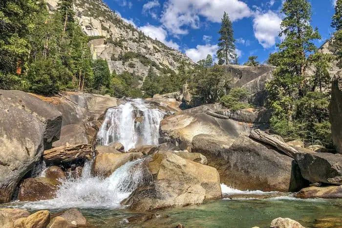
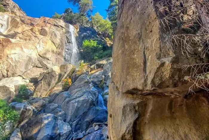
I would rate this trail as moderate, and it is 8.7 miles long and has very heavy traffic. It is located in Hume, California, and you will get to experience features like waterfalls and mountain scenery. From May to October, you can choose to use this trail for backpacking and camping. The waterfall was charming and also the whole hike in general. The only thing I didn’t like were the bugs and gnats; make sure you carry insect repellant with you. We also got to see some snakes on the trail, but they immediately went back into the woods, so we were safe. Make sure that you are always aware of your surrounding, no matter how great the trail is.
Length: 8.7 mi
Elevation gain: 879 ft
Route type: Out & back
Backpacking, Camping, Hiking, Waterfall, Wildflowers, Wildlife
Kings Canyon National Park Hiking Trail #2 – Rae Lakes Trail
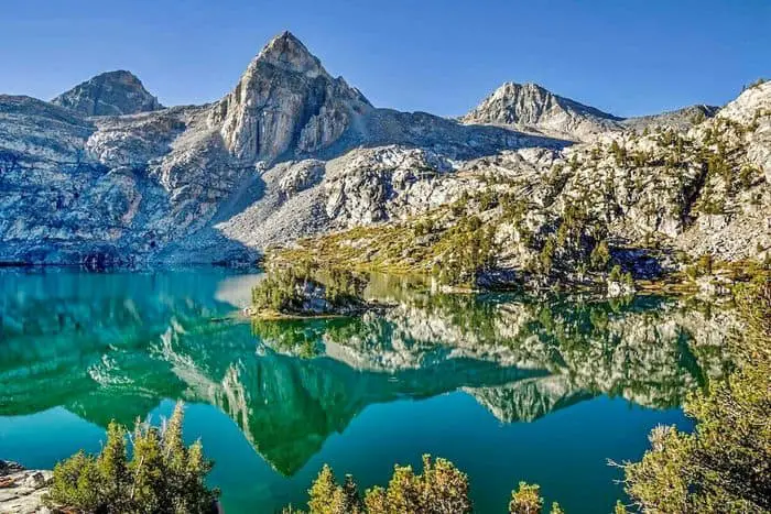
This trail is rated as hard, and that is not a lie; it is 39 miles long and heavily trafficked. It is found near Cedar Grove, California, where there is also a lake that you will enjoy. Some of my favorite sections in this trail were Rae lakes and Paradise Valley.
Length: 39.1 mi
Elevation gain: 7,670 ft
Route type: Loop
Backpacking, Camping, Hiking, Forest, Lake, River, Views, Waterfall, Wildflowers, Wildlife
Kings Canyon National Park Hiking Trail #3 – General Grant Loop Trail
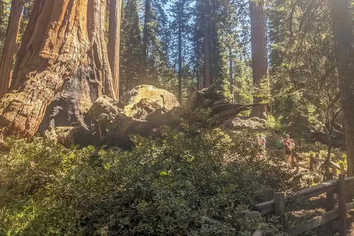
This is one of the most accessible trails I got the chance to go on. It is .07 miles long and heavily trafficked. It features a river, and no matter your skill level, you will love this trail. I found that the trail was well maintained, and I got to enjoy the National Christmas tree view. If you visit the Kings Canyon National park with your family, you should go on this trail. You will get to enjoy views like the fallen Monarch tree and the Gamlin Cabin.
Length: 0.7 mi
Elevation gain: 32 ft
Route type: Loop
Wheelchair friendly, Kid friendly, Stroller friendly, Hiking, Walking, Bird watching, Forest
Kings Canyon National Park Hiking Trail #4 – Zumwalt Meadow and Roaring River Falls
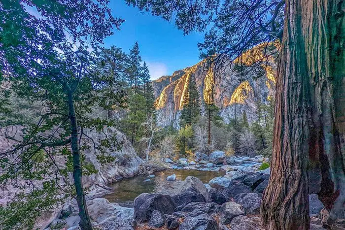
I would rate this trail as easy as you can go on it with any skill level. It is 5.5 miles long and moderately trafficked. It is located near Sequoia National Park and features a waterfall. This trail is excellent for bird watching, hiking, fishing, and running. I love this trail, it is lovely, and it is a great place to go with your family. Some places are very rocky, so you have to be careful and wear the proper shoes. If you get too hot, there are many shady spots so that you can rest while you enjoy the views.
Length: 5.4 mi
Elevation gain: 419 ft
Route type: Out & back
Kid friendly, Fishing, Hiking, Bird watching, Running, Waterfall, Wildflowers, Wildlife
Kings Canyon National Park Hiking Trail #5 – Paradise Valley Trail
This trail was pretty hard, and we sweated a lot; it is 29.3 km long and should be hiked by people with experience. No matter the hardness of the hike, the view was to die for, starting with the waterfall. When we hiked, it was a bit warm, but we still made it up. The definite highlight was mist falls, and it was so breathtaking. Don’t also forget to bring bug spray because you will encounter lots of gnats. There is also some smoke as you go up, but it is worth it.
Length: 18.2 mi
Elevation gain: 2,506 ft
Route type: Out & back
Backpacking, Hiking, Walking, Bird watching, Waterfall, Wildflowers
Kings Canyon National Park Hiking Trail #6 – Roaring River Falls Trail
Another easy trail that everyone can enjoy is the Roaring River Falls Trail. It is a on-third miles long and also features a waterfall that is great to view. Unlike other easy trails, this one is less crowded hence very serene. It is a bit rocky, so you have to look where you walk, but, overall, it is very spectacular. Don’t forget to carry plenty of water and wear proper shoes so that you can get to enjoy the place.
Length: 0.3 mi
Elevation gain: 26 ft
Route type: Out & back
Kid friendly, Hiking, Walking, Partially paved, Waterfall
Kings Canyon National Park Hiking Trail #7 – Zumwalt Meadow Trail
This is also another easy trail to go on with your family. It is 2.4 km long and is located near Sequoia National Park. This trail also has stunning sceneries, and you can also opt to choose it for running. The trail was straightforward, and it also had a lot of shades where we got to pull to the side and relax.
Length: 1.5 mi
Elevation gain: 157 ft
Route type: Out & back
Wheelchair friendly, Kid friendly, Stroller friendly, Hiking, Walking, Running, Partially paved, Wildflowers, Wildlife
Kings Canyon National Park Hiking Trail #8 – Hart Tree, Fallen Goliath, Redwood Creek Loop
In my opinion, this trail was moderate, it is 7.3 miles long, and it also features a waterfall. This trail offers several activities, to enjoy them with your family and friends. My friends and I did clockwise, but you can choose to go the other way round; I loved the trees the most. They were very majestic and worth the hike. If you get to start early as we did, you will have the trail all to yourself.
Length: 7.3 mi
Elevation gain: 1,305 ft
Route type: Loop
Backpacking, Camping, Hiking, Walking, Bird watching, Running, Waterfalls, Wildflowers, Wildlife, Historic site
Kings Canyon National Park Hiking Trail #9 – Big Baldy Ridge
I would rate this trail as moderate, and it is one of the best trails at the Kings Canyon National Park. One of its best features is the river, and also the road is very well maintained and in excellent condition. Some areas are very bumpy, steep, and narrow, so you have to be careful.
Length: 6.4 mi
Elevation gain: 1,423 ft
Route type: Out & back
Camping, Hiking, Bird watching, Wildflowers, Wildlife
Kings Canyon National Park Hiking Trail #10 – Grizzly Falls
[wprm-recipe-roundup-item link=”
https://www.google.com/maps/place/Grizzly+Falls+Picnic+Area/@36.8031121,-118.7459686,17z/data=!3m1!4b1!4m5!3m4!1s0x80957cb5853cb1e3:0x75e890db953ea2e3!8m2!3d36.8031121!4d-118.7437799″ nofollow=”1″ name=”Grizzly Falls” summary=”
The last trail I enjoyed was the Grizzly Falls trail. it is an easy trail and measures one-tenth of a mile long. It features a waterfall and can be hiked by people of all skill levels. Don’t forget to carry a good camera and water shoes to get the whole experience. The waterfall gave us instant gratification, but you have to go early to find a good place to park.
Length: 0.1 mi
Elevation gain: 19 ft
Route type: Out & back
Kid friendly, Hiking, Walking, Forest, Waterfall
Places and Things to Do and See in Kings Canyon National Park
When a friend recommended that I visit this park, I was first skeptical because I did not know what to see or do and had no idea of all the places it offers. You will have to go there to experience for yourself, but there are several activities to participate in and different sites you will love. I am going to list some of them that I enjoyed a lot and am sure that you will enjoy them too.
Grant Grove Stables
This stables are located just ten minutes from the entrance, and we got to enjoy horseback rides. It was my first time riding a horse, but there was a guide with me all through day. It was a two-hour guided ride, and we went all through the forest, getting to experience the excellent views. This place is a definite visit if it is your first time there and you don’t know where to start.
Grant Grove
This grove is a must-visit; many trails led to the grove both around and through the trees and canyons. My wife and I used the dead giant loop, and we got to see some waterfalls and meadows while seeing the beautiful giants. There is also a nearby Grant grove village with a visitor center, and we found a gift shop and a market. You will also be able to find any information you want at the visitor center.
Boyden Cavern
The Boyden Cavern is a marble cave where I enjoyed stalactites, massive stalagmites, and even flowstone. The tour was approximately one hour long; the marble walls were 2000ft high. The cliffs were windy, and the whole experience was terrific. You have to book early, and walk-in tours are not guaranteed.
General Grant Tree
This tree is a must tree because it is named the second largest tree in the world. I love Christmas, so I was definitely in love with this tree, it was like a huge holiday tree and you will never forget seeing it. I think that is why the tree is nicknamed the nation’s Christmas tree. The trail to this tree is paved and is 1/3 mile long, and I also got to enjoy other features like Centennial Stump, Gamlin Cabin, and the Fallen Monarch while on this hike. If you visit the tree in December, you will get to join others honoring fallen armed services, and you get to lay a wreath down for them at the base of the tree.
Cedar Grove
I got the chance to drive down to the bottom part of Kings Canyon National park, and I was rewarded with the views. There were breathtaking rock formations, and the area was less crowded, unlike other parts. There were beautiful sceneries that I would recommend, and you can also choose to enjoy the hike as we did.
Zumwalt Meadow
The last place I visited was the Zumwalt meadow; it is found inside the Canyon and has high granite walls. It was one of my best hikes, it was 1.5 miles long, and we got to view the meadows, Canyon, rushing rivers, wildflowers, and giant trees. This is a place I would recommend; I enjoyed every bit of the hike.
You May Want to Join Our Boondocking Group on Facebook For More Information
You May Want to Join Our Campfire Recipes Group on Facebook For More Information
This would have been a 5 star but there was only about three sites available due to the road closed fist by a fallen tree across road about 200 feet from turnoff from 180. Then there is a road closure another 100 feet from the fallen tree. The usual pigs left litter around the existing campsites so some cleanup will be needed or you will attract more bears than already around. Good location to Hume Lake. No cell service