I would definitely recommend to add a day or two and visit the Grand Canyon Parashant National Monument. If you every become fortunate enough to go to the Grand Canyon North Rim don’t miss it. Whether you go alone, with friends, or take the whole family I can assure you it is a once in a life time experience that you will never forget.
The scenery is unmatched no matter where you explore and the people are hospitable and friendly. The Grand Canyon Parashant National Monument is one of the most traveled to places in the entire United States. It’s beauty leaves you in awe. The memories you make there will be cherished forever.
Want more ideas to round-out your trip to Arizona?
A lot of great ideas are in these posts!
- 18 Saguaro National Park Boondocking (Update 2022)
- Top 10 Chiricahua National Monument Boondocking Locations
- 18 Great Vermilion Cliffs National Monument Boondocking Locations
- 17 Free Canyon de Chelly National Monument Boondocking Spots
- 16 Casa Grande Ruins National Monument Free Camping and Boondocking Spots
- 91 Free Northern Arizona Boondocking Locations
- 15 Grand Canyon Parashant National Monument Boondocking (Updated 2022)
- 8 Ironwood Forest Monument Boondocking (Updated 2022)
- 12 Free Organ Pipe Cactus Monument Boondocking (Updated 2022)
- 17 Agua Fria National Monument Boondocking (Updated 2022)
- 10 Great Monument Valley Boondocking (Updated 2022)
- 11 Awesome Catalina State Park Boondocking Locations
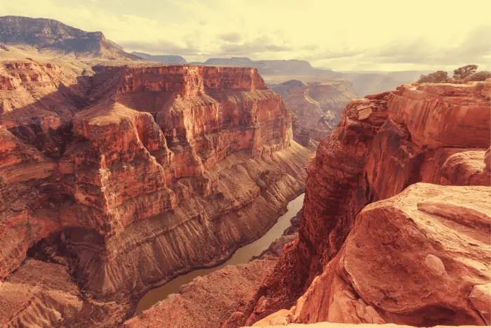
The Grand Canyon Parashant National Monument is located on the North rim of the Grand Canyon. It is a 1,014,000 acre area in north western Arizona. It is believed that the Grand Canyon itself was formed five to six million years ago when the Colorado River cut it’s way through the area forming the mile deep canyon. It is thought that humans have inhibited the area since the Ice Age.
Ruins and artifacts dating back nearly 12,000 years have been discovered by archeologists. The Grand Caynon achieved national park status in 1919. It wasn’t long the creation of the national park service. Since then the area has become widely known as a travel destination. It has become populated, explored, and adored by all who visit. There is no other place on Earth quite like it. The canyon itself is one mile deep, and 18 miles wide and over 270 miles long.
Many tribes once inhabited the area including the Pueblo. The Paiute people, the Navajo, Zuni, and Hopi tribes also all once lived in and around the canyon. Tribal history states that the Havasupai lived in the area for well over 800 years. Pictures, drawings and sketches of animals have been found inside the caves that are within the walls of the canyon. They are thought to be part of a ritual that was done to ensure successful hunting.
The first more modern day explorer of the Grand Canyon was Joseph Christmas Ives. He and a fellow named John Newberry explored the canyon is 1858 while on an expedition along the Colorado River. Newberry is known as the first geologist the study the area.
In 1903 our late great president Theodore Roosevelt visited the Grand Canyon. He adored it so much that he felt the need to protect it for future use and exploration. He declared that certain areas become protected as wildlife and game reserves. These areas later became known as the Grand Canyon Parashant National Monument.
15 Best Grand Canyon Parashant National Monument Boondocking Locations
check out our video
1. Grand Canyon Parashant National Monument Boondocking Locations – Grand Canyon-Parashant National Monument Pakoon Springs
Address
Pakoon Springs Road
Littlefield, Arizona
GPS: 36.418255, -113.960678
Elevation: 2288′
Management: Bureau of Land Management
The road into this Grand Canyon Parshant boondocking area is Dirt. You may stay two weeks (14 days) at Grand Canyon-Parashant National Monument Pakoon Springs.
Best Review:
There are no developed campsites with facilities within the national monument. Visitors can pick their own campsite, but please camp at least 200 feet from water sources and use biodegradable soap. Camping is permitted for up to 14 days. See the map linked to the right for monument boundaries.

2. Grand Canyon Parashant National Monument Boondocking Spots – Whitney Pockets
Address
Arizona Road
Bunkerville, Nevada
GPS: 36.524198, -114.133117
Elevation: 3144′
Management: Bureau of Land Management
The road into this Grand Canyon Parshant free campsite area is Gravel. There are 6-15 campsites at this location and the maximum RV length is unlimited. Free boondocking on BLM owned desert land. Flat and open at the base of beautiful red rock. Dry camping in the middle of the desert. No facilities or utilities. No reservations taken.
Best Review:
Absolutely stunning. Let’s be clear about this road…it’s 20 miles of gravel/pothole/rock disaster but MAN IS IT WORTH IT. Its an exquisite drive through the desert mountains. Cacti, Joshua Trees, and beautiful red rocks. Just make sure you’ve got a full tank and everything you need. This is the most magnificent view of Nevada ever, and so close to the Arizona/Utah border.
3. Grand Canyon Parashant National Monument Boondocking Campsites – Virgin Mountains
Address
Lime Kiln Canyon Road
Littlefield, Arizona
GPS: 36.689193, -114.019015
Elevation: 3166′
Management: Bureau of Land Management
Free Dispersed camping in the Bureau of Land Management Arizona Strip District. Reservations are not accepted at this campsite. The road into this Grand Canyon Parshant boondocking area is Dirt.
Best Review:
None
4. Grand Canyon Parashant National Monument Boondocking Spots – South Cove
Address
GPS: 36.088919, -114.105943
Management: Public
Follow pierce ferry road north of Meadview, Az. Go to the south cove boat drop off. Right before the lake, turn left on to a dirt road. Drive 5 minutes and camp on the shore where there are fire rings. The road into this Grand Canyon Parshant free campsite area is Dirt.
Best Review:
Beautiful place to stay – lake and mountain views, rock formations overlooking the lake shore, gorgeous sunsets and sunrises. Not really very level but manageable. Stayed here in a 26′ class A and a tent, January 2nd and 3rd 2020. Close enough to Grand Canyon West for a daytrip.
5. Grand Canyon Parashant National Monument Boondocking Locations – Fire Cove
Address
Park Road 106
Overton, Nevada
GPS: 36.403654, -114.401166
Elevation: 1306′
Management: National Park Service
The road into this Grand Canyon Parshant boondocking area is Dirt 4×4. Fire Cove is open year round. There are 6-15 campsites at this location and the maximum RV length is 15 feet. You may stay 15 days at Fire Cove.
Best Review:
Free dispersed camping in Lake Mead National Park. A fun little ride in your high clearance vehicle. You may camp anywhere along this road. The end is little more than a brushy, large, flat area in a wash. We didn’t see another person here and we only saw two sets of tire tracks. That’s probably because there is no real access to the water. You could probably walk there, but it’s about a mile away. ATT G and Verizon 3G but neither were usable.
6. Grand Canyon Parashant National Monument Boondocking Locations – Stewart’s Point – Lake Mead NRA
Address
Overton, Nevada
GPS: 36.378967, -114.401642
Elevation: 1233′
Management: National Park Service
Stewart’s Point – Lake Mead NRA is open Year Round. There are 30 or more campsites at this location. You may stay 15 days at Stewart’s Point – Lake Mead NRA. The road into this Grand Canyon Parshant free campsite area is Dirt.
Best Review:
None
7. Grand Canyon Parashant National Monument Boondocking Spots – Overton Wildlife Management Area
Address
Nevada
GPS: 36.5165, -114.4241
Elevation: 1243′
Management: State Park
Overton Wildlife Management Area is open year round. There are 6-15 campsites at this location. You may stay 8 days at Overton Wildlife Management Area. Overton Wildlife Management Area located 2 miles S of town. Unlimited RV size, 8-day limit. This area is managed by the Nevada Department of Wildlife. GPS approximate. The road into this Grand Canyon Parshant boondocking area is Dirt.
Best Review:
I found this a fairly nice place to stay in March 2019. Don’t count on finding a free spot here. Five large sites with trees for privacy. I didn’t find it too noisy. The two vault toilets are inside the WMA fencing… one not far from the registration kiosk. Dumpster. You can go inside the gate and walk everywhere but not in hunting season. There are lots of dirt roads not walkable after rain. Some of the roads lead to pretty ponds.
8. Grand Canyon Parashant National Monument Boondocking Campsites – Virgin River-Littlefield, AZ
Address
Littlefield, Arizona
GPS: 36.82445, -113.99497
Elevation: 1814′
Management: Bureau of Land Management
The road into this Grand Canyon Parshant free campsite area is Gravel and 1/2 miles from a paved road. Virgin River-Littlefield, AZ is open All year. You may stay 14 days at Virgin River-Littlefield, AZ. Quiet and flat campsites with views of the Virgin River and Arizona Mountains. 14 days limit camping. Cellphone service available. Close to the freeway I-15 and the old highway.
Best Review:
Easy to find, but its filthy. broken glass EVERYWHERE! but its a good alternative if you’re traveling South on I15 since apparently there’s no more rest stops after Kanarraville Utah. If I was driving North I’d just go to Kanarraville Rest Stop. There was more people than I anticipated, but was still able to find a spot to park and get some sleep. And I felt comfortable and safe.
9. Grand Canyon Parashant National Monument Boondocking Locations – Free camping at Walmart
Address
Mesquite, Nevada
GPS: 36.805627, -114.105522
Elevation: 1657′
Management: Retail Store
The road into this Grand Canyon Parshant boondocking area is paved.
Best Review:
None
10. Grand Canyon Parashant National Monument Boondocking Spots – Free spot close to Valley of Fire & Lake Mead
Address
Moapa Valley, Nevada
GPS: 36.441255, -114.439055
Elevation: 1624′
Management: Bureau of Land Management
The road into this Grand Canyon Parshant free campsite area is Dirt. You may stay 14 days at Free spot close to Valley of Fire & Lake Mead. Dirt road to many potential spots. Careful, sandy spots could be tricky. Got stuck with my 21ft RV, with a hitch tray. Had to remove generator and hitch tray off the back to be able to get out of a sandy ditch. Didn’t look soft on foot.
Best Review:
None
11. Grand Canyon Parashant National Monument Boondocking Locations – Sand Mine Road
Address
Sand Mine Road
Overton, Nevada
GPS: 36.471602, -114.440813
Elevation: 1604′
Management: Bureau of Land Management
The road into this Grand Canyon Parshant boondocking area is Dirt. The maximum RV length at Sand Mine Road is unlimited. You may stay 14 days at Sand Mine Road. Dispersed camping on BLM land near Valley of Fire State Park and Lake Mead. Level, quiet, and wide open. Full sun. Services and a dump station are 7 miles away in Overton. The road in is in great shape for the first few miles.
Best Review:
Loved it. Great views, weather, walking. Extremely peaceful. Only downside is the spiney plants if you go beyond campsite perimeter. Stayed 2 wéeks because it was perfect for me.
12. Grand Canyon Parashant National Monument Boondocking Spots – Snowbird Mesa aka Poverty Flats
Address
Sandmine Road (unmarked)
Overton, Nevada
GPS: 36.48497, -114.444626
Elevation: 1592′
Management: Bureau of Reclamation
The road into this Grand Canyon Parshant free campsite area is Dirt and 1 miles from a paved road.
Best Review:
According to the “residents” of the mesa it is free camping from October to June and managed by the bureau of reclamation. I found only 1 reference at the listed website (scroll down to Overton section). It listed no max stay. There were about 40 campers, some in boats, tents, truck toppers big rigs. Water is available and dump down the road about 10 – 15 miles to Echo Bay.
13. Grand Canyon Parashant National Monument Campsites – Echo Wash
Address
Echo Wash Road
Overton, Nevada
GPS: 36.308955, -114.445626
Elevation: 1247′
Management: National Park Service
The road into this Grand Canyon Parshant boondocking area is 4×4. Echo Wash is open year round. There are 6-15 campsites at this location and the maximum RV length is 15 feet. You may stay 15 days at Echo Wash. This dispersed camping area is just south of Echo Bay Road and down a wash. The wash can get sandy so 4×4 is recommended. High clearance is also good. To get there exit at Bitter Springs Road and go back under the bridge.
Best Review:
None
14. Grand Canyon Parashant National Monument Boondocking Locations – Meadview Overlook
Address
Meadview, Arizona
GPS: 35.939639, -113.976044
Elevation: 5528′
Management: Bureau of Land Management
The road into this Grand Canyon Parshant free campsite area is Dirt. You may stay 14 days at Meadview Overlook.
Best Review:
Camp near the edge of the mesa and overlook Meadview and Lake Mead. At night you’ll see the glow of Vegas to the west. Take the road toward the Grand Canyon Skywalk then turn left(north) when you’re near the top. There’s a big gravel pile and a sign for the Skywalk and you’ll go over a cattle guard. It’s a slow 7.5 miles over a dirt road that I would not recommend for a regular car.
15. Grand Canyon Parashant National Monument – Logandale Trails System
Address
Nevada
GPS: 36.593724, -114.526805
Elevation: 1811′
Management: Bureau of Land Management
The road into this Grand Canyon Parshant boondocking area is Dirt. Logandale Trails System is open Year round. There are 30 or more campsites at this location and the maximum RV length is unlimited.
Best Review:
The Logandale Trails System (LTS) contains over 200 miles of trails, suitable for a variety of OHV types, as well as hiking and horseback riding. Be sure to respect the land and its resources during your visit. Otherwise, the LTS will lose what makes it a fantastic place for recreation.
Places To Go and Things To Do At the Grand Canyon Parashant National Monument
There are many places to visit in the Grand Canyon area. I was amazed by Hells Hole. How breathtakingly beautiful and natural it is. The Tassi and Waring ranches are also definitely awesome to check out. The Grand Canyon is an excellent place to ATV, walk, run, hike, ride horses, take photos, and observe nature. Many visitors enjoy the South rim of the Grand Canyon the most. Don’t forget to check out Grand Gulch mine, and Havasu Falls as well if you have the time!
5 Most Popular Trails At Grand Canyon Parashant National Monument
Anyone who’s stood at a Grand Canyon National Park overlook knows this natural wonder can appear inconceivably huge. But from the remote wilderness perch where I’m sitting, it’s even bigger.
High atop 7,866-foot Mt. Logan in northwestern Arizona, I lean back on my elbows and gaze at the most spectacular Grand Canyon panorama I’ve ever seen. Spreading out before me in kaleidoscopic relief is not only the massive canyon, but also its sister region, the Shivwits Plateau, a place 19th-century cowboys called the “high, wide, and lonesome” country.
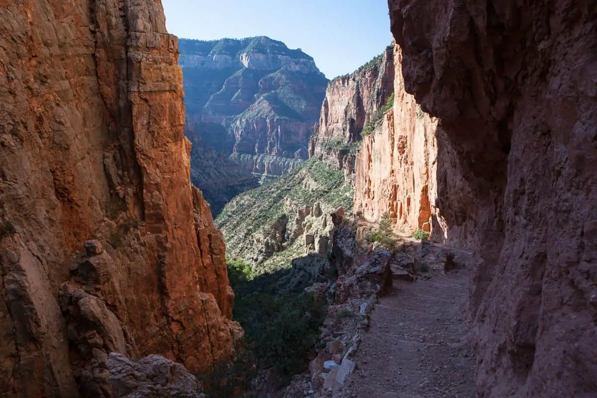
Grand Canyon Parashant National Monument Hiking Trail #1. Bright Angel Point Trail
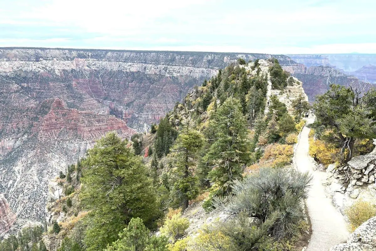
The Bright Angel Point hiking trail is one of the shorter, easier hiking trails. It takes about a half an hour to complete and is absolutely invigorating to hike. It is a more family oriented trail and is much safer than some of the others. It is less than a mile long and heavily used. The Bright Angel Point trail is located near North Rim, Arizona. The wildlife is amazing and the views are just absolutely breathtaking. If you’ve never hiked in the Grand Canyon before the Bright Angel Point trail is an excellent place to start.
Length: 0.9 mi
Elevation gain: 144 ft
Route type: Out & back
Kid friendly, Hiking, Nature trips, Walking, Partially paved, Views, Wildlife, Fee, No dogs
Grand Canyon Parashant National Monument Hiking Trail #2. Uncle Jim’s Trail
The Uncle Jim Trail is another of the easier trails, but is a little longer. The Uncle Jim Trail is 4.7 miles long and is moderately trafficked. The Uncle Jim Trail is located near North Rim, Arizona and is best for use from May through October. I found that this trail is great for riding horses on. It is so peaceful and relaxing. Here you can enjoy all nature has to offer as the forest is just full of plant and wildlife. I totally loved watching birds on this trail as there is such a vast variety to observe.
Length: 4.7 mi
Elevation gain: 731 ft
Route type: Loop
Kid friendly, Backpacking, Camping, Hiking, Horseback riding, Nature trips, Walking, Bird watching, Running, Forest,
Wildflowers, Wildlife, Rocky, No dogs
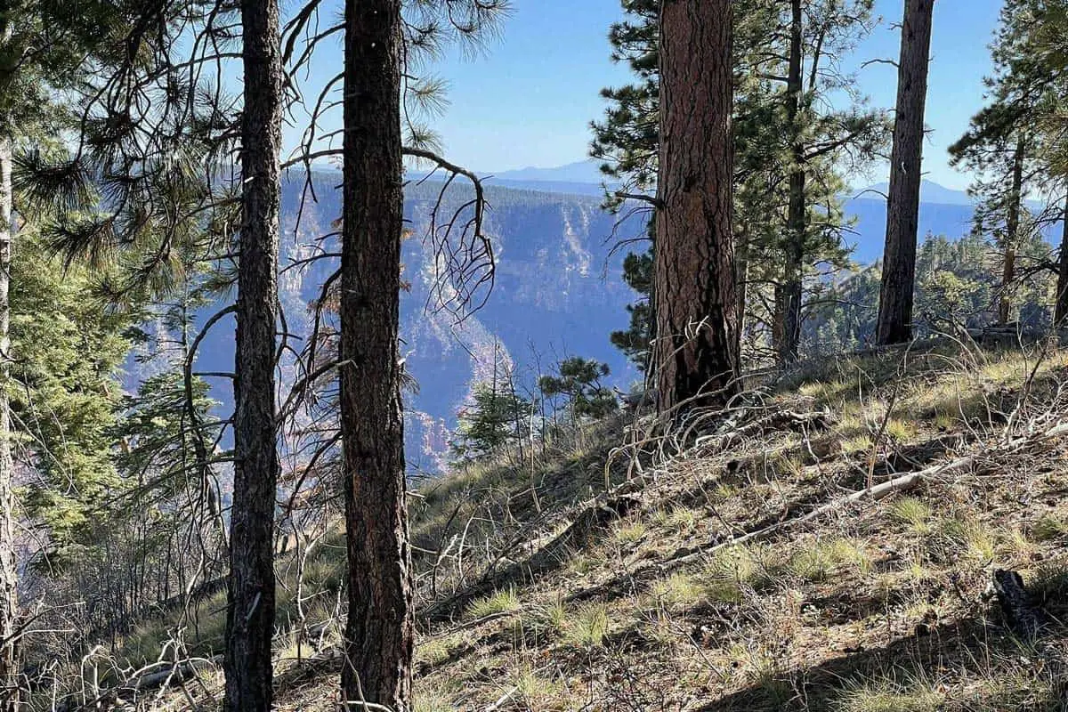
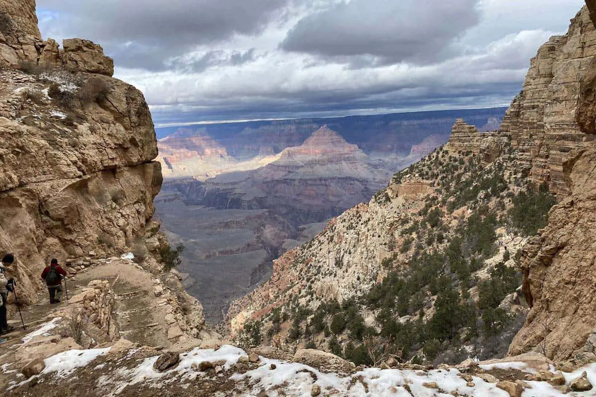
Grand Canyon Parashant National Monument Hiking Trail #3. The North Kaibab Trail
The North Kaibab Trail is an exquisite journey down to the Colorado River. This 28.0 mile long trail is full of adventure and excitement as it enters the Grand Canyon from the North Rim. I was so impressed by this trail for two reasons. The first, the Supai Tunnel, and the second, Roaring Springs. I highly recommend it!
Length: 28.0 mi
Elevation gain: 6,866 ft
Route type: Out & back
Backpacking, Camping, Hiking, Nature trips, Bird watching, Running, Cave, River, Views, Waterfall, Wildflowers,
Wildlife, Rocky, No shade, Historic site, Fee, No dogs
Grand Canyon Parashant National Monument Hiking Trail #4. The Monument Canyon Trail
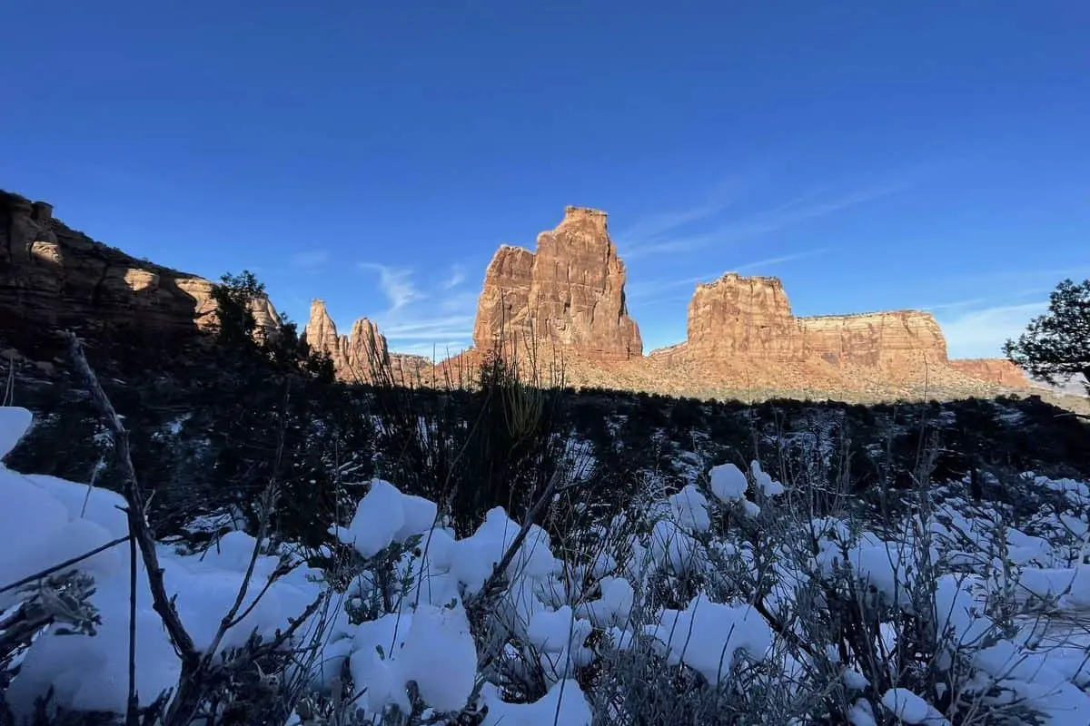
The Monument Canyon Trail is moderate in difficulty. It isn’t one of the hardest trails, but it isn’t one of the easiest either. The Monument Canyon Trail is 11.6 miles long. It is one of the more well used trails. The Monument Canyon Trail is located near Grand Junction, Colorado. It is known for several varieties of beautiful wild flowers which seem to grow abundantly. This trail is accessible all year for runners, rock climbers, and nature enthusiasts. It is a great work out and will get your soul in touch with nature. I found it to be Heaven on Earth as did many of those I encountered while hiking it. What an experience!
Length: 11.6 mi
Elevation gain: 1,873 ft
Route type: Out & back
Hiking, Nature trips, Rock climbing, Running, Views, Wildflowers, Wildlife, Rocky, Fee, No dogs
Grand Canyon Parashant National Monument Hiking Trail #5. The South Kaibab Trail
The South Kaibab Trail to Cedar Ridge is another moderate trail. I found this trail to be closer to a hard trail and I suggest you are physically fit or really determined to hike it. However the views here are simply stunning as is the scenery. The South Kaibab trail is an incredible 2.8 miles long. It’s exhilarating to say the least! Make sure to bring your camera as you’ll likely see some amazing things you’ll never see again!
Length: 2.8 mi
Elevation gain: 1,102 ft
Route type: Out & back
Hiking, Cave, Forest, Views, Wildflowers, Wildlife, Rocky, Fee, No dogs
Things To Remember While Visiting the Grand Canyon Parashant National Monument
The Grand Canyon Parashant National Monument is incredible, but it can also be dangerous. Make sure to learn about the trails you choose before embarking on your journey. Also be sure to have plenty of water, and to avoid times of high heat. Always have a map and compass if you do not have a guide. It is easy to get lost in the vast terrain. If you really plan to do some deep exploring let someone know your intentions so if you do happen to get lost someone will come try to find you. With that said I hope you enjoy this amazing area as much as I did. I will cherish the memories I made there for life and maybe beyond! Be sure to bring a camera! There are so many things to see you’ll certainly want to capture them all!
You May Want to Join Our Boondocking Group on Facebook For More Information
You May Want to Join Our Campfire Recipes Group on Facebook For More Information