
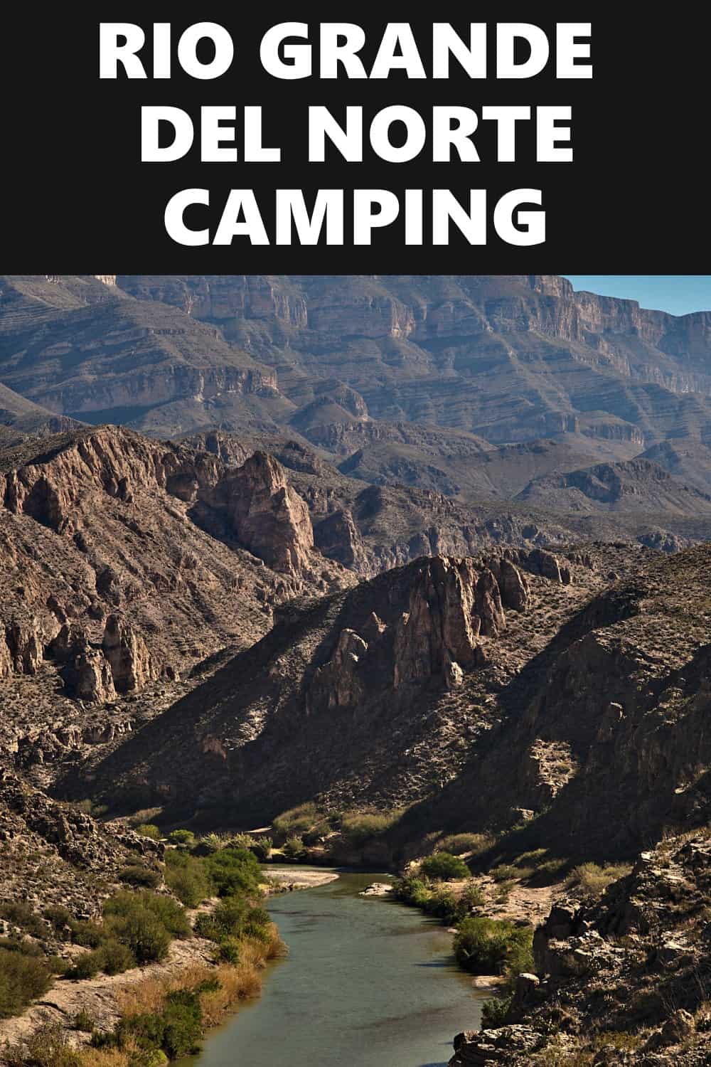
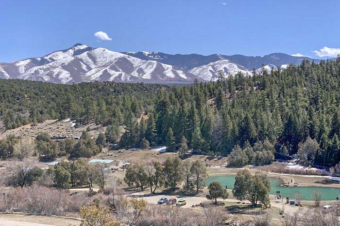
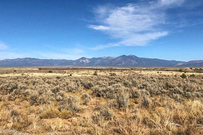
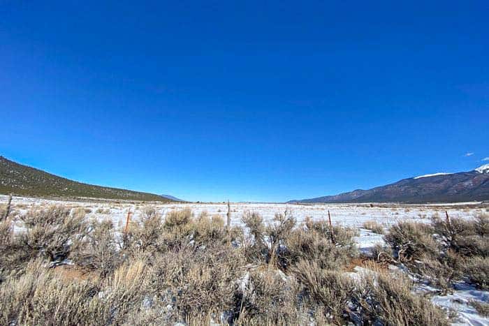
The Rio Grande del Norte National Monument in Taos County, New Mexico is a 380 square mile piece of land declared a national monument by President Obama in 2013. The monument is comprised of parts of the Taos Plateau volcanic field. When we visited the monument, we got to see the Ute mountain with heights of 30 890 feet.
We also had a swim in the Carge Springs which outflow from flooded lava tubes. We had a lot of fun rafting and boating in the rapids, which varied between Class II and IV, only with a guide. Most of the trails were perfect for mountain biking and hiking as we enjoyed the scenery.
Want more ideas to round-out your trip to New Mexico?
A lot of great ideas are in these posts!
- 14 Free Rio Grande del Norte Boondocking (Updated 2022)
- 141 Best New Mexico Boondocking Spots Plus Maps
- 17 White Sands National Park Boondocking & Free Camping Sites
- 12 Top Las Cruces Free Camping and El Paso Boondocking Stops
- 9 Best El Morro National Monument Boondocking Spots
- 16 Gila Cliff Dwellings Monument Boondocking (Updated 2022)
In the Red River and the Rio Grande, you get the chance to fish for rainbow and brown trout, and hunting is also allowed at the monument, subject to game regulations. The monument also proves to be a good place for camping as there are five camping grounds, with one being by the river.
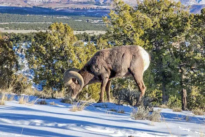
The Rio Grande del Norte National monument is home to Elk, Mule, Deer, Cougars, Coyotes, Bear and a bunch of other animals as the monument acts as an essential area for wildlife who use it as a winter corridor between the mountains.
History of the Rio Grande del Norte National Monument.
The Rio Grande Valley has been inhabited by the Jicarilla Apache, the Utes, as well as the Taos Pueblo and Picuns Pueblo since the archaic period. Proof of their habitats lies in the petroglyphs found on the rock surfaces, and the stone tool remains that have been unearthed in the mountains. The San Antonio Mountains acted as a good source for dacite, used for tool building.
In the 1800s, the Spanish and the English began settling in the valley. The Spanish began to enslave the Pueblo tribes and forced them to work in the gold mines.
This led to the Pueblo revolt in 1680, where the Pueblo expelled thousands of Spanish settlers from the valley.
The Spanish undeterred returned later but eventually lost the territory to Mexico in the Mexican war for independence. However, the Mexican government gave up this territory to the USA in the Treaty of Guadalupe Hidalgo in 1848 after the Mexican-American war.
In the 19th century, the region became popular with French settlers. The town of Questa became inhabited by French fur trappers who decided to stay in the area even after the fur trade ended. The arrival of the Denver and the Rio Grande railroad in 1870 made the region an essential stopping point on the rail line. Ranching and other agricultural activities remain the primary source of livelihood in the area.
The Rio Grande was one of the eight rivers to be designated as a Wild and Scenic river in 1968. The Rio Grande del Norte National monument, however, was only designated as such by President Obama in 2013. Portions of the monument were designated as wilderness areas under the bipartisan John D Dingell Jr Conservation, Management and Recreation act in 2019.
14 Free Rio Grande del Norte National Monument Boondocking Locations
check out our video
1. Rio Grande del Norte National Monument Boondocking – Sublette
Address
Tierra Amarilla, New Mexico
GPS: 36.990354, -106.227828
Elevation: 9370′
Management: National Forest Service
This Rio Grande del Norte National Monument boondocking area is by the old railroad stop of Sublette NM. This is on Carson National Forest lands.
Best Review:
From the Antonito CO Cumbres Toltec train station drive roughly 10 miles west. Turn left on to county road D.5 and then hang a right about a half mile down the road. Hang a left a short distance later and stay straight on this road until you get close to the waypoint. There’s numerous dispersed camping sites in this area.

2. Rio Grande del Norte National Monument Boondocking Locations – Rio de Los Pinos Campground
Address
Tierra Amarilla, New Mexico
GPS: 36.9549, -106.1749
Elevation: 8346′
Management: National Forest Service
The road in is Gravel and 8 miles from a paved road. There are 6-15 campsites at this location. You may stay 14 days at Rio de Los Pinos Campground. 4 developed campsites + dispersed camping at 8000′ with superb river fishing access just west of NM Game & Fish Recreation Area
Best Review:
There are 2 areas to camp at this Rio Grande del Norte National Monument boondocking free campsite area, the first is managed by the Rio de los Pinos Wildlife Management Area. There are at least six “parking areas” to camp for free. Great for larger rigs, not as ideal for tent camping.
The second area is 15 miles in on a decent gravel/dirt road and is managed by the Carson National Forest. These are great sites next to the river. There are 2 vault toilets (they were locked in early October in 2020), and a handful of sites with picnic tables, maybe 8. The fire rings are handmade out of stone.
3. Rio Grande del Norte National Monument Camping Spots – Rio de los Pinos SWFA
Address
Los Pinos River Access Road
Tierra Amarilla, New Mexico
GPS: 36.953003, -106.120069
Elevation: 8156′
Management: State Park
This Rio Grande del Norte National Monument boondocking area is a free dispersed campsite. This campsite does not use a reservation system. First come, first served. This is a high elevation location.
Best Review:
There are 2 areas to camp here, the first is managed by the Rio de los Pinos Wildlife Management Area. There are at least six “parking areas” to camp for free. Great for larger rigs, not as ideal for tent camping.
4. Rio Grande del Norte National Monument RV Parking – Laguna Larga
Address
Forest Road 78A
Tierra Amarilla, New Mexico
GPS: 36.884203, -106.107326
Elevation: 9004′
Management: National Forest Service
There are 1-5 campsites at this Rio Grande del Norte National Monument boondocking free campsite. You may stay 14 days at Laguna Larga. Four dispersed campsites are set on fishing water’s edge at 9000′, dispersed camping elsewhere around lake.
Best Review:
None
5. Rio Grande del Norte National Monument Hiking – San Antonio Mountain
Address
Tres Piedras, New Mexico
GPS: 36.919008, -105.986313
Management: Bureau of Land Management
The road into this Rio Grande del Norte National Monument boondocking area is Dirt and 500 Feet miles from a paved road. San Antonio Mountain is open March to November. There are 1-5 campsites at this location and the maximum RV length is unlimited. You may stay 14 Days at San Antonio Mountain.
Best Review:
Beautiful views of San Antonio mountain or continue up 118 for possibly more camping. Very remote, no service. The road was super rough and washed out when I went, but it had just rained. Signs advise no passenger cars continue beyond the staging area.
6. Rio Grande del Norte National Monument Boondocking – Antonito Spray Park
Address
101, 199 E 3rd Ave, Antonito, CO 81120
Antonito, Colorado
GPS: 37.074183, -106.00804
Elevation: 7887′
Management: County Park
The road into this Rio Grande del Norte National Monument boondocking free campsite is Paved. Antonito Spray Park is open Year Round. There are 6-15 campsites at this location and the maximum RV length is unlimited.
Best Review:
This is a small city park that allows parking behind it, on the dirt road 3rd ave. A short walk from downtown and Cano’s castle, but there isn’t much else to see around town.
7. Rio Grande del Norte National Monument Boondocking Locations – Elk Creek Trail
Address
Forest Road 128
Antonito, Colorado
GPS: 37.119511, -106.377123
Elevation: 8812′
Management: National Forest Service
The road into this Rio Grande del Norte National Monument boondocking area is Dirt. The maximum RV length at Elk Creek Trail is unlimited. Free dispersed camping in a big open area with lots of sun and room for any sized rig. No Verizon service.
Best Review:
A great boondocking spot! Stayed here May 19th and 20th. Arrived Wednesday night and had the place to myself. Thursday night there were three additional campers. Judging by the firings, it will get much busier as the summer progresses. There is no Verizon service at the camp. The nearest service was in the area of the town of Magote, about 15 miles away. I will definitely be back!
8. Paid Site – Rio Grande del Norte National Monument Camping Spots – San Luis Park at Sanchez Stabilizing Reservoir
Address
Sanford, Colorado
GPS: 37.169564, -105.516527
Elevation: 7825′
Management: National Forest Service
Rio Grande del Norte National Monument boondocking free campsite is a little park on the side of the road. Can accommodate multiple RVs. Good for a quick stop – overnight RV parking. Vault toilet.
Best Review:
None
9. Paid Site – Rio Grande del Norte National Monument RV Parking – Trout Lakes Campground
Address
FR 125
Tierra Amarilla, New Mexico
GPS: 36.606389, -106.378942
Elevation: 9301′
Management: National Forest Service
The road into this Rio Grande del Norte National Monument boondocking area is Dirt and 11 miles from a paved road. Trout Lakes Campground is open End of May. There are 1-5 campsites at this location and the maximum RV length is 15 feet. You may stay N/A at Trout Lakes Campground.
Best Review:
Good little site. Got 1 bar on Verizon, but 1/2 mile back down the forest road, I got 3 bars. The road up here is super-slick when wet. Between that and rocks and washouts, a 4wd is probably smart unless it’s been very, very dry. Lots of dispersed camping along the road on the way up, too. I can’t speak to the fishing.
10. Paid Site – Rio Grande del Norte National Monument Hiking – Canjilon Creek
Address
Forest Road 130
Canjilon, New Mexico
GPS: 36.543393, -106.317381
Elevation: 9350′
Management: National Forest Service
The road into this Rio Grande del Norte National Monument boondocking free campsiteis Paved. Canjilon Creek is open seasonally. There are 6-15 campsites at this location and the maximum RV length is 25 feet. You may stay 14 days at Canjilon Creek. This campsite is located within the Carson National Forest’s Canjilon Ranger District. This is a high elevation location.
Best Review:
None
11. Paid Site – Rio Grande del Norte National Monument Boondocking – El Rito Creek
Address
County Road 437
Vallecitos, New Mexico
GPS: 36.579431, -106.168588
Elevation: 8009′
Management: National Forest Service
The Rio Grande del Norte National Monument boondocking area at El Rito Creek is open Apr-Nov. This free campsite is located within the Carson National Forest’s El Rito Ranger District. This is a high elevation location.
Best Review:
None
12. Paid Site – Rio Grande del Norte National Monument Camping Spots – Tres Piedras
Address
Tres Piedras, New Mexico
GPS: 36.655331, -105.977997
Elevation: 8240′
Management: National Forest Service
The road into this Rio Grande del Norte National Monument boondocking free campsite is Dirt and 0.25 miles from a paved road. Tres Piedras is open Year Round. There are 6-15 campsites at this location. You may stay 14 at Tres Piedras. Open Ponderosa forest at the foot of the largest of the rock formations in Tres Piedras.
Best Review:
I was in the area of these sites and found some others by taking Forest Road 64J which is less than a mile up US 64. You’ll see a big green water tank as soon as you turn on to FR 64J. The road veers to the left of the water tank and there are several dispersed sites with aged rock and concrete grill pits. Many of the trees in the area are cut down with most others marked to be cut down. Not sure what the plan is for the area.
13. Rio Grande del Norte National Monument Boondocking – Mesa Public Access near Taos, NM
Address
Tres Piedras, New Mexico
GPS: 36.55611, -105.77014
Elevation: 7169′
Management: Bureau of Land Management
The road into this Rio Grande del Norte National Monument boondocking area is Dirt. Mesa Public Access near Taos, NM is open year round. You may stay 14 days at Mesa Public Access near Taos, NM. Rutted dirt road with pullouts.
Best Review:
Happened to find this when El Aguaje campground was closed. It’s a beautiful place. Found a flat spot to camp with great views not too far from the road. A little bit of broken glass, but not a ton of trash like some places. I set up my tent, but the wind picked up a lot as night fell .
14. Rio Grande del Norte National Monument Boondocking Locations – Cebolla Mesa
Address
Forest Road #9
Questa, New Mexico
GPS: 36.640555, -105.684872
Elevation: 7382′
Management: National Forest Service
The road into this Rio Grande del Norte National Monument boondocking free campsite is Dirt and 3.4 miles from a paved road. Cebolla Mesa is open May – October. There are 1-5 campsites at this location and the maximum RV length is 35 feet. Cebolla Mesa is in the Carson National Forest.
Best Review:
Perfect for a free spot! Gorgeous views all around, toilet ( lock still broke), picnic tables and fire pits with grills. Spots are walk in, but not difficult like some are. Often people show up but few camp out and those generally for one night. A must-see site and there are spots beyond those first seen, so probably 8-10 spots total. Got pretty good signal at my spot, stayed two weeks.
Top 10 Trails to Hike in the Rio Grande del Norte National Monument
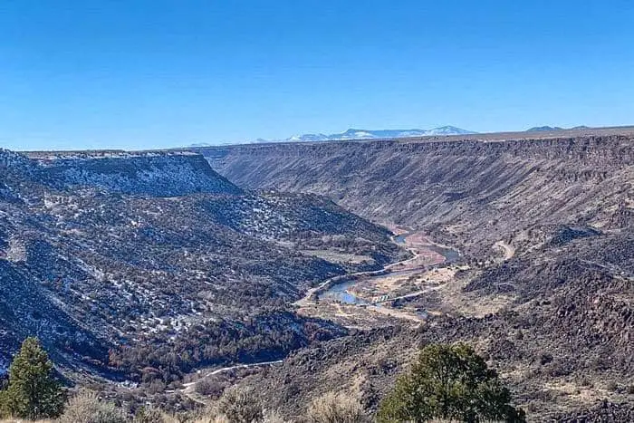
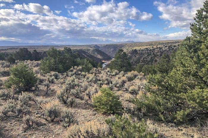
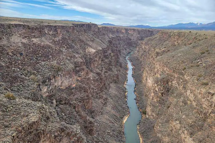
Begin your journey with a trip to the Taos Gorge Bridge, the seventh tallest bridge in the U.S. At the bridge grounds, you can walk along a short section of the Rim Trail to learn about its dynamic geological story while soaking in the incredible views of the Rio Grande Rift and the river, of the same name, below.
From there, you will voyage into the Rio Grande Del Norte National Monument for an interpretive guided experience. This land displays evidence of the ancient peoples’ regional inhabitance with petroglyphs, prehistoric dwellings sites and other archeological discoveries, and in so doing, previews Taos Pueblo’s long ancestral connection to the land.
Rio Grande del Norte National Monument Hiking #1. Black Rock Hot Springs Trail
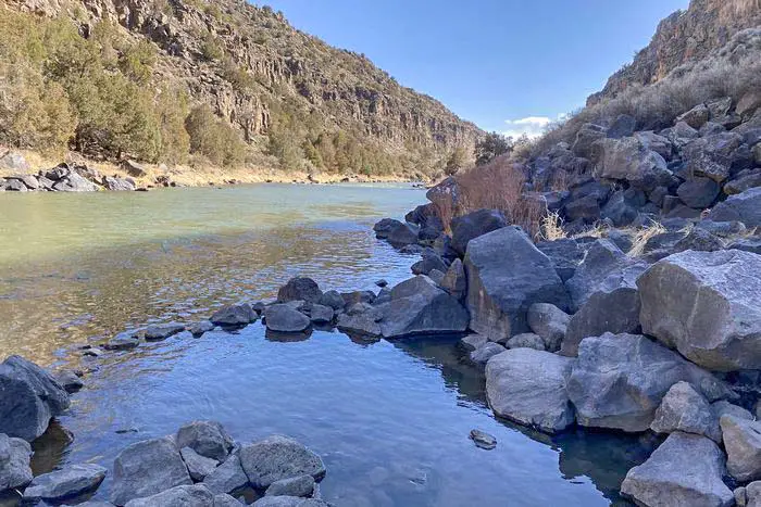
This trailer was relatively easy for us to hike on, although it was very rocky and had a very steep descent towards springs. We had a swim in the springs, where the main pool had a temperature of about 99 degrees Fahrenheit, which was kind of perfect. The adjacent pools were not as warm as they were mixed with the river water. The Pools had a depth of about three to four feet and could hold up to five adults. It was clothing optional, and many locals did dive into the pools naked.
Length: 0.3 mi
Elevation gain: 68 ft
Route type: Out & back
Hiking, Bird watching, Dog friendly, Hot springs, River, Views, Wildlife, Scramble
Rio Grande del Norte National Monument Hiking #2. Trader’s Trail
This was a quick, easy hike as we enjoyed the long mountain views of the Wheeler Peak and the Eastern ranges of Taos. The pictures on this trail are not as appealing as those on the other trails, not to mention the large amounts of dog poop on the first half-mile of the trail. The view of the desert did provide us with some fantastic opportunities to take pictures though.
Length: 3.3 mi
Elevation gain: 337 ft
Route type: Out & back
Hiking, Walking, Running, No shade
Rio Grande del Norte National Monument Hiking #3. The Rift Valley Loop Trails
The 7.2km trail is mostly flat, so it was not as challenging as we hoped. We did get to see some beautiful sagebrush desert, prickly pear, Indian brush, and some stripped Whiptail lizards. Apart from the plants and the animals, there was a fantastic view of the Gorge. This trail was not challenging at all, so if you are searching for a challenge, we recommend you hike other trails at the Rio Grande Del Norte National Monument.
Length: 10.3 mi
Elevation gain: 879 ft
Route type: Loop
Hiking, Horseback riding, Mountain biking, Walking, Running, Dog friendly, Views, Wildlife, Muddy, Snow
Rio Grande del Norte National Monument Hiking #4. Pescado Trail
We began this trail at the entrance Pay Station. The trail was flat for the first mile, so it was an easy hike. From then on, there was a steep descent through the Ponderosa, where we saw some pretty rock formations. There was a picnic table 10 minutes away from the parking lot where we took a short break before soldiering on. The trail was splendid as it was shaded, and we got to see all sorts of flowers and birds.
Length: 3.4 mi
Elevation gain: 728 ft
Route type: Out & back
Fishing, Hiking, Forest, River, Views
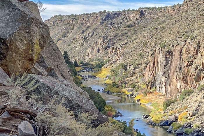
Rio Grande del Norte National Monument Hiking #5. North Hondo Ridge Trail
We hiked this trail in the winter, so we had to do it counterclockwise to avoid the winds, which blew a little strong. There was no snow on the trail, and had very little shade. It did provide us with a great view of the Rio Grande and the surrounding mountains.
Length: 3.5 mi
Elevation gain: 334 ft
Route type: Loop
Dogs on leash, Hiking, Mountain biking, Walking, Bird watching, Running, Views
Rio Grande del Norte National Monument Hiking #6. Chiflo Trail
We walked this trail as we headed down to the river from Mesa. It was a lovely walk even though it was in the snow. The trail did have two picnic shelters, one below the Rim and one by the river. The water in the river had a relatively slow current, so we decided to go for a quick dip.
Length: 0.7 mi
Elevation gain: 334 ft
Route type: Out & bac
Hiking, Walking, Bird watching, Running, Forest, River, Views
Rio Grande del Norte National Monument Hiking #7. La Junta Trail to Lookout Point
We had a fantastic time hiking this trail as it was primarily flat with a few ups and downs. The view of the river below was incredible, not to mention the beautiful rocks. The trail was a little chilly as it was exposed to the wind. There were a few mountain bikers along the way, but the trail was generally empty. It was well marked; hence it was pretty easy to follow.
Length: 0.3 mi
Elevation gain: 9 ft
Route type: Out & back
Dogs on leash, Wheelchair friendly, Kid friendly, Stroller friendly, Backpacking, Camping, Hiking, Walking, Paved, River, Views, Wildflowers, Wildlife, No shade.
8. West Rim Petaca Point Trail
The trail has no shade or coverage, so it is best to avoid it during summer. Part of the trail is along the service road, and it does not go along the Rim, so we did not get to experience the views of the Gorge until we reached the Point. The wait was worth it, though, as we had a 360-degree view of the surrounding mountains and the Mesa once we arrived at the Point.
Length: 7.8 mi
Elevation gain: 403 ft
Route type: Out & back
Backpacking, Hiking, Views, Wildlife, No shade
Rio Grande del Norte National Monument Hiking #9. La Vista de Questa Trail
We hiked this trail in the afternoon, and it was a pretty nice walk. The first mile was flat and had little to no shade. We had some lunch on the lower observation point and proceeded to the upper observation Point, where there was a bench to rest on while we enjoyed the view. The trail did get steep in some parts, but it was not a challenging climb overall. We did not encounter any people all through, so it is a good trail if you want to avoid crowds.
Length: 3.8 mi
Elevation gain: 629 ft
Route type: Loop
Dogs on leash, Kid friendly, Hiking, Walking, Views, Wildflowers, Wildlife, No shade
Rio Grande del Norte National Monument Hiking #10. Rio Grande Gorge West Rim Trail
We decided to make this trail in the morning as the vendors on the trailhead were setting up their tables to sell their crafts. This trail has picnic tables overlooking the Gorge, which was a good place for us to sit and refresh. The trail was relatively easy, and we enjoyed the fresh air and some great views. There were some benches along the way where we took some much-needed breaks before moving on.
Length: 3.7 mi
Elevation gain: 236 ft
Route type: Out & back
Dogs on leash, Kid friendly, Hiking, Horseback riding, Mountain biking, Running, No shade
The Rio Grande Del Norte National Monument is a delightful place to be if you love hiking. The sheer number of trails provides you with varying options. It is also a perfect place for mountain bikers, and if you a looking for white water raft, they have got you sorted too.
Activities in the Rio Grande Del Norte National Monument.
1. Fishing -The Rio Grande River is one of Colorado’s largest and most popular rivers. It is a fun river to fish in as it has spectacular access and holds some large trout such as the Truchas Grandes. The campgrounds along the rivers of the Rio Grande del Norte National monument make it a good place to spend a few days and fish as you relax and enjoy the high-altitude scenery.
2. White Water Rafting – At the Rio Grande del Norte National Monument, White water rafting is the most enjoyable outdoor activity in northern New Mexico during the spring and summer months. The adventure starts at the Colorado border, to the remote Razor Blades section, to the Iconic Taos box canyon, and finally ends at the Rio Grande del Norte Racecourse. The Rio Grande Del Norte National Monument offers family floats and world-class white water rafting experiences.
3. Mountain Biking and Hiking – The Rio Grande del Norte National Monument has excellent trails where you can take your bike for a ride and have a good time. Hikers can also enjoy these fantastic trails.
You May Want to Join Our Boondocking Group on Facebook For More Information
You May Want to Join Our Campfire Recipes Group on Facebook For More Information