The Arches National Park is one of the great parks in the world due to its eye-catching features. It’s located in Utah, United States. The park has several things that give you all the reasons to visit it. Some of these include its iconic delicate textbook Utah arch. The park contains natural sandstone in the largest number in the world. It is a textbook Utah the arches possess contradicting qualities in terms of coarseness, height, curvature, and balance.
Visiting this park is affordable, as it offers little effort to accessibility, a big payoff, and only a few areas such as the Fiery Furnaces that require access permits. The park offers a lot, to hikers, whitewater rafter, photographers, and more.
The Arches National Park has many notable features- balanced rock, delicate arch, dark angel, devils garden trail, courthouse towers, landscape arch, double arch, wall arch, fiery furnace, petrified arch, and more. It’s a great place for bicycling, backpacking, touring, camping, canyoneering, hiking, rock climbing, etc.
Want more ideas to round-out your trip to Utah?
A lot of great ideas are in these posts!
- 24 Amazing Arches National Park Hiking Trails – Easy, Moderate, Hard
- 19 Great NE Utah Boondocking Spots With Maps
- 32 Free North-Central Utah Boondocking Areas Along With Maps
- 24 Top NW Utah Boondocking Locations Including Maps
- 51 Amazing East-Central Utah Boondocking Campsites And Maps
- 33 Best Central Utah Boondocking Sites Also Maps
- 21 Favorite West-Central Utah Boondocking Camp Sites Plus Maps
- 36 Free SE Utah Boondocking Camping Sites And Maps
- 43 Amazing South-Central Utah Boondocking Campgrounds With Maps
- 54 Top SW Utah Boondocking Camping Areas Including Maps
The Arches National Park was established back in April 1929 and was designated as a national monument. The park is located in the southern region of Utah, in the United States. Later in 1971, President Richard Nixon through congress-signed legislation reduced its area of enclosure significantly, and its status changed into a national park. The park covers a total area of 76,679 acres.
For thousands of years, the area now under the Arches national park was inhabited by Native Americans. The region attracted a huge number of researchers, especially on the monument idea. To support the idea, a polar explorer and a geologist from the University of Michigan- Laurence assisted in studying the geology of this scenic area. The Arches national park has natural sandstone arches of more than two thousand.
In 1980, there was an attempt made by Vandals of defacing the park’s ancient petroglyphs using kitchen cleaners that were said to be abrasive. In this situation, the damage was to be cleared by John Asmus using laser technology. The Arches national park is found on top of a weathered salt bed. The rock bed has undergone extreme climatic changes a long time ago.
Free and Paid Camping Options For the Arches National Park
The Arches National Park offers admission for seven days. However, you are going to incur some costs here and there during your visit. For instance, when it comes to the park entrance fees: private vehicles are charged a fee of $30 and should have a capacity of 15 passengers or less. Here the cost is for the non-commercial vehicle and its occupants. A motorcycle is charged a fee of $25, for the rider and the private motorcycle. When you are a pedestrian, hiker, bicyclist, or any other person without a car, you are admitted at a fee of $15. Only individuals with 15 years and below are admitted for free.
The Arches national park camping fee varies depending on a particular camping ground. For Devils garden campground, one to ten campers attracts a fee of $25 per night in the individual site. If you and the team want to camp at the Canyon Wren group site, the fee varies depending on the number of campers. Eleven to sixteen campers are charged $75 per night, 17 to 22 campers cost $100 per night, and the list goes on. For the Juniper group site, a team of 11 to 22 campers pays a fee of $100 per night. The fee increases with an increase in the number of campers.
Top 15 Boondocking Sites for Arches National Park
check out our video
1. Arches National Park Free Campsites and Boondocking – Dalton Wells Camping Area
Address
Moab, Utah
GPS: 38.717797, -109.689383
Elevation: 4396′
Management: Bureau of Land Management
The road in is 4×4. Dalton Wells Camping Area is open year round. There are 6-15 campsites at this location and the maximum RV length is unlimited. You may stay 14 days at Dalton Wells Camping Area. A free camping area to the north of Arches National Park and Moab. Plenty of spots.
Best Review:
4×4 or front wheel drive suggested. There is a sandy wash that you must cross to get to the camping area. Camping is not allowed within 1/2 mile of highway 191, well past the wash. The camping areas are flat and open with full sun. There are lots of roads and rails for jeeps and OHV here. Decent Verizon 4G. No ATT data w/o booster.

2. Arches National Park Free Campgrounds and Boondocking – Willow Springs Road
Address
Willow Springs Road
Moab, Utah
GPS: 38.696832, -109.6981
Elevation: 4430′
Management: Bureau of Land Management
The road in is Dirt. Plenty off pullouts and places to camp off Willow Springs Road (BLM 378)… it is a dirt road but our sedan did just fine getting down in a little ways from 191.
Best Review:
None
3. Arches National Park Free Campsites and Boondocking – Cotter Mine Campsites
Address
Moab, Utah
GPS: 38.698374, -109.708278
Elevation: 4688′
Management: Bureau of Land Management
The road in is Gravel. There are 6-15 campsites at this location and the maximum RV length is unlimited. You may stay 14 days at Cotter Mine Campsites.
Best Review:
Free designated campsites along Cotter Mine Road. This road connects to the parking lot indicated by the Mill Creek campsite. Each end of Cotter Mine Rd has an info sign with a map showing where the campsites are. You can only camp in sites with a tent symbol on a stake and you can’t build new fire rings. I chose the second from the south because it’s isolated from the other sites and is set back from the gravel road and has a panoramic view. Bare gravel, no plants, but hey… it’s MOAB, not Seattle!
4. Arches National Park Free Campgrounds and Boondocking – Klondike Bluffs Trail Rd
Address
38.74093452196912, -109.73388938084946
Moab, Utah
GPS: 38.75803, -109.7255
Elevation: 4636′
Management: Bureau of Land Management
The road in is Dirt. Klondike Bluffs Trail Rd is open Year round. There are 30 or more campsites at this location and the maximum RV length is unlimited. You may stay 14 days at Klondike Bluffs Trail Rd. Starting at the Colorado River, drive 15 miles north from Moab.
Best Review:
This is a great open area to stay; we stayed for four nights. There is a trail head near the end of the road. One of the trails leads to dinosaur tracks. There are also many other trails to hike on; they are also mountain biking trails. There were only two bikers during our hike. We parked on the east side of a steep hill so we could be in the afternoon shade. The La Sal Mountain range can be seen from our spot. Beware of the ruts in parts of the road and on the way to certain campsites. The area is roughly 20 miles from downtown Moab; about 15 miles from the entrance to Arches National Park. We used a WeBoost to use our cell phones and laptops.
5. Arches National Park Free Campsites and Boondocking – Gemini Bridges Campsites
Address
Gemini Bridges Road
Moab, Utah
GPS: 38.612202, -109.665496
Elevation: 4669′
Management: Bureau of Land Management
The road in is 4×4. There are 1-5 campsites at this location and the maximum RV length is 25 feet. You may stay 14 days at Gemini Bridges Campsites 1-5. Campsites 1-5 are clustered together in a beautiful red rock canyon, but they well spaced out with lots of junipers between them.
Best Review:
Only one campsite was occupied when I visited. The campsites are little more than a clear, flat spot with a rock fire ring. There are no facilities. You must pack your trash out! You must bring everything that you will need, You are required to have portable toilet to camp here. Each campsite can hold 2-3 vehicles. The ground is a fine sand. The road from highway 191 is an intimidating high clearance road that only rugged vehicles should try to traverse. After a couple of miles, the road tames. This area is a Bighorn birthing area and dogs must be leashed. No cellular signal at the campsites.
6. Arches National Park Free Campgrounds and Boondocking – Castleton Tower’s Climbers Campsite
Address
Moab, Utah
GPS: 38.642319, -109.376765
Elevation: 4915′
Management: Utah Open Lands Conservation Association
The road in is Gravel. There are 1-5 campsites at this location and the maximum RV length is 35 feet.
Best Review:
One of my favorite spots in the Moab area. Located right off of La Sal loop road in Castle Valley. This is a climbers campsite for the Tower, but is technically open to everyone. You don’t have to be an expert climber to hike the trail that takes you right up to the base of the Tower. Bring your camera, Amazing views. There is about 4 sites here with plenty of urban sprawl. Its a free site but they do ask for donations. A pit toilet, no water, no fires allowed. Controlled by Utah Open Lands Conservation Association.
7. Arches National Park Free Campsites and Boondocking – Bartlett Wash Camping
Address
Utah
GPS: 38.717671, -109.785491
Elevation: 4636′
Management: Bureau of Land Management
The road in is Gravel. There are 1-5 campsites at this location and the maximum RV length is 35 feet. Killer little site off the beaten path. Bike paths and hiking paths right at the start of the campsites. About 3 camping sites and a parking site that could be used as overflow.
Best Review:
Stayed about 3 nights in early May, 2019. Camp is right along the road where a fair amount of off road traffic accesses the trails, but not noisy or dusty at night. Nice secluded spot with trees and beautiful rocks to hike and bicycle nearby. Walk in camp sites as well as adequate parking for an RV. If you have a trailer, DO NOT try to enter off 189 on BLM 343 from the south; enter from the north off 189 near the Canyonlands Airport on Blue Hills Rd to Mill Canyon Rd and then to Bartlett Washington Rd.
8. Arches National Park Free Campgrounds and Boondocking – North Klondike Trails, Moab, Utah
Address
Utah
GPS: 38.827396, -109.778821
Management: Bureau of Land Management
The road in is Dirt and 3 miles from a paved road. North Klondike Trails, Moab, Utah is open All year. There are 30 or more campsites at this location and the maximum RV length is 35 feet. You may stay 14 days at North Klondike Trails, Moab, Utah.
Best Review:
Lat 38.827 Long – 109.779 If you don’t mind being 5 miles North of Canyonland turn off, about 10 miles North of Moab off 191,there are acres of pretty quiet free BLM camping. This is also the entrance of the Dinosaurs, fossils entrance but you go straight instead of making a right. Nice dirt roads, no high clearance required and you can go in as far as you want. We stayed about a quarter mile from the highway. Been here a couple times and have only seen a couple cars go by. No facilities and the stay is most likely 14 days. It is a good stopover for us for a couple nights. Verizon is 4G 4~5 bars non boosted. [I don’t have one!]. By the way I unless really bad for many reasons I always rate a free campsite 5 stars! It’s free!
9. Arches National Park Free Campsites and Boondocking – US-191 and Copper Ridge JSR
Address
BLM 143
Moab, Utah
GPS: 38.82588, -109.78082
Elevation: 4662′
Management: Bureau of Land Management
Less than 0.2mi off the highway. Despite being very close to the road and the nearby RR tracks, this is reputedly a convenient overnight spot for those on the way.
Best Review:
Pulled a trailer in here and it was a bit rocky to get to some camping spots. A sedan might be able to do it if you are careful. High clearance vehicle is preferable but 4×4 is not necessary. I have T-Mobile and the internet was screaming fast out here for some reason. Was streaming movies each night! 🙂 I also took my telescope and the night sky is excellent for Astrophotography
10. Arches National Park Free Campgrounds and Boondocking – Capitol Reef Super Stash
Address
Moab, Utah
GPS: 38.72499, -109.30853
Elevation: 4747′
Management: Bureau of Land Management
Free BLM Dispersed Camping -> No Reservations
Best Review:
Our favorite place with incredible views of the valley. Depending on the time of the year 4×4 possible. I recommend a vehicle that has high clearance in case road is rutted out. There is NO ONE around except the sounds of nature.
11. Arches National Park Free Campsites and Boondocking – Small Pullout Off On BLM Rd 137
Address
Moab, Utah
GPS: 38.641008, -109.814553
Elevation: 5344′
Management: Bureau of Land Management
Small Pullout on left side of road if traveling North West down road in between both Lone Mesa campgrounds from highway 313. This is a small area with room for 3 or 4 sites. There is an unmarked trail that leads up the hill perpendicular to the road way. A small walk leads to the top to reveal 360 degree views of the area, privacy, large space and small fire pit.
12. Arches National Park Free Campgrounds and Boondocking – BLM 137
Address
BLM 137, Utah
Moab, Utah
GPS: 38.644005, -109.819677
Elevation: 5290′
Management: Bureau of Land Management
The road in is Gravel. You may stay 14 days at BLM 137. Turn off 313 near milepost 14, onto BLM 137. There is a sign for Lone Mesa Group Campground. Turn onto gravel road. Instead of turning right to Lone Mesa Campground continue down gravel road about a mile. You will see campsite on your left.
Best Review:
I stayed in the loop area with all the RVs. Good service! No facilities. It is in a desert environment, so a portable toilet system is needed. Quite crowded. Hed people park very close to me two nights in a row. Not the best place for privacy. The road was rough. I had to drive fairly slow in my prius, but made it without much issue. (Side note: other cars were booking it down the gravel road and rocks would fly everywhere, so keep a good distance from other cars). Good location between Arches and Canyonlands.
13. Arches National Park Free Campsites and Boondocking – Long Canyon Dispersed Camping
Address
Moab, Utah
GPS: 38.539848, -109.71217
Management: Bureau of Land Management
The road in is 4×4. There are 1-5 campsites at this location.
Best Review:
None
14. Arches National Park Free Campgrounds and Boondocking – Kokopelli’s Trail – Porcupine Rim
Address
Forest Road 4632
Moab, Utah
GPS: 38.575105, -109.347077
Elevation: 7408′
Management: Forest Service
The road in is Dirt. There are 1-5 campsites at this location and the maximum RV length is 35 feet. This campsite is at high elevation and one of the notable camping location along the Kokopelli Trail.
Best Review:
Great place with a great view. Google maps took me through sand flats rec area and they require a $5 entrance fee so just be aware of that. The road turns to dirt about a quarter of the way into sand flats and it can be wash boarded at times. The final leg to the sites would be ideal to have some clearance and I would definitely recommend good tires. This would be tricky to get to if rain is recent.
15. Arches National Park Free Campsites and Boondocking – Thompson Welcome Center
Address
I-70 exit 190
Thompson, Utah
GPS: 38.95127, -109.68373
Elevation: 5036′
Management: Rest Area
The road in is Paved. Thompson Welcome Center is open year round. There are 1-5 campsites at this location and the maximum RV length is unlimited. You may stay a couple of hours at Thompson Welcome Center. Westbound only.
Best Review:
The Welcome center is located in the small town of Thompson a few miles from the full-service town of Moab. This is world-famous Red rock country with two national parks, Arches and Canyonlands, and a state park, Dead Horse Point, within a short driving distance.
Top 10 Trails to Hike at the Arches National Park
A day of hiking in Arches National Park is one that pairs world-famous landmark views with a humbling sense of respect for the desolate stretches of sandstone formations. The park is one of Southern Utah’s most famous hiking destinations, with an easily accessible network of trails that often culminate right at the base of an impressive sandstone arch. Start building out your to-do list by exploring the park’s trails below, or keep planning by finding a a place to stay near the park.
1. DELICATE ARCH
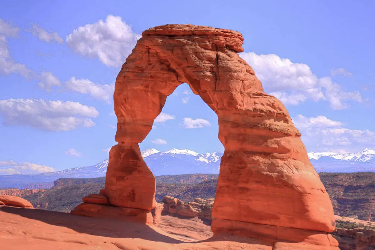
The trail to Delicate Arch is one of the most popular hikes in Arches National Park. It requires a 3-mile round trip hike to get up-close-and-personal to the arch, but the hike is worth it.
This hike is considered “difficult” because of the lack of shade and the potential for slippery rock in bad weather. There is also a steep cliff to traverse at the end right before you reach the arch.
There are easier options to view Delicate Arch – though, they are from a distance. Drive past the Wolfe Ranch parking lot to reach the upper and lower viewpoint areas.
The lower viewpoint is only 100 meters from the parking lot, while the upper viewpoint requires a 0.5-mile hike.
Length: 3.2 mi
Elevation gain: 629 ft
Route type: Out & back
Kid friendly, Hiking, Partially paved, Views, Wildflowers, Wildlife, Rocky, No shade, Fee, No dogs
2. DEVIL’S GARDEN LOOP
This primitive trail is a 7.2-mile loop that showcases 7 unique arches like Tunnel Arch, Pine Tree Arch, Navajo Arch, Partition Arch, Wall Arch, Double O Arch, and Landscape Arch.
Some people only hike up to Landscape Arch and turn around, but if you decide to continue on you will see a lot of unique arches in the park that many don’t experience.
Take plenty of water on a hot day, and if it’s been raining or snowing, consider another day. The rock can be extremely slippery when wet!
If you aren’t up for doing the entire 7.2-mile loop, the easy alternative is going to Landscape Arch and turning around.
This is a 2-mile out and back trail that is relatively flat and accessible to all levels of hikers!
Length: 1.7 mi
Elevation gain: 643 ft
Route type: Loop
Hiking, Mountain biking, Running, Views, Wildflowers, Wildlife
3. FIERY FURNACE
The Fiery Furnace trail gets you inside a maze of narrow canyons for an up-close look at the towering sandstone pillars and walls.
To do this hike, you must go on a ranger-led hike or obtain a permit. You can easily pick up a day-use permit at the visitors center.
Inside, they highly recommend you follow the marked trail signs because visitors frequently get lost in the sandstone labyrinth. Make sure to carry lots of water and prepare to spend a few hours exploring this hike in Arches National Park!
Length: 0.2 mi
Elevation gain: 13 ft
Route type: Out & back
Kid friendly, Walking, Views, Wildflowers, Wildlife, Fee, No dogs
4. DOUBLE ARCH

The trail to Double Arch is an easy 0.5-mile well-maintained loop, accessible from the parking lot of the Windows area.
When reaching Double Arch, you can climb up to peer on the other side of the arch, or explore the bowl underneath.
You can climb around in a sort of open-cave like structure for amazing views from above. Read about another arch in a cave on a hike to Soldiers Pass in Sedona!
This is less of a hike and more of a walk so you’ll find a lot of children and families here because of the convenience of the parking lot!
Length: 0.6 mi
Elevation gain: 95 ft
Route type: Out & back
Wheelchair friendly, Kid friendly, Stroller friendly, Hiking, Walking, Views, Wildflowers, Wildlife, No shade, Fee, No dogs
5. SAND DUNE AND BROKEN ARCH

The trail to Sand Dune Arch is a 0.3-mile trail through deep sand to reach the secluded arch. This is a great hike for all skill-levels, and visitors can walk right next to the tall sandstone walls.
To extend the trail, you can continue walking to Broken Arch, which makes the trip a 1.7-mile out and back loop. Interestingly, Broken Arch isn’t actually broken, though it has considerable wear.
These two arches are great options for easy and beautiful hikes to take in Arches National Park!
Length: 1.4 mi
Elevation gain: 154 ft
Route type: Out & back
Hiking, Walking, Running, Views, Wildlife, Scramble, Fee, No dogs
6. WINDOWS LOOP

This easy 1.2-mile loop connects three stunning arches in the park. This is one of the most popular loop hikes in Arches National Park because of the accessibility and relatively short trail, and the concentration of formations in one place.
If you’re not looking for a strenuous hike, or if you have a limited amount of time to spend in the park, make this area a priority!
Turret Arch is the smallest of the three, but it’s surrounded by a castle-like formation with stairs leading right under the arch, making it an appealing attraction.
From Turret Arch is a great view of both the North and South Windows. This place is also popular for night photographers.
The North and South Windows are easy to reach and you are able to stand under the huge arches.
Length: 0.7 mi
Elevation gain: 98 ft
Route type: Loop
Kid friendly, Hiking, Walking, Views, No dogs
7. LANDSCAPE ARCH

Spanning 306 feet long, Landscape Arch is the longest natural arch in the world!
This arch can be seen as part of the Devil’s Garden loop trail, and it is located at the end of the manicured trail – any farther and you’ll be taken on the long and strenuous 7-mile loop.
In 1991, a car-sized piece of rock fell from Landscape Arch in the night. This is a normal occurrence as erosion breaks down the arches in the park. However, you can no longer stand directly under the arch for obvious safety purposes.
Make sure to visit this arch in the park before erosion takes it for good!
Length: 1.9 mi
Elevation gain: 252 ft
Route type: Out & back
Kid friendly, Hiking, Walking, Partially paved, Views, Wildflowers, Fee, No dogs
8. SKYLINE ARCH

Skyline Arch is less than a half a mile from the trailhead (you can practically see it from the main road). The parking lot is actually just a pullout, enough for maybe 3-4 cars on either side.
The name of this Arch is self-explanatory – it’s on the skyline!
This hike can easily be paired with Landscape Arch because they are both located in the proximity of the Devil’s Garden Loop and are both short enough to accomplish within a few hours time.
Length: 0.4 mi
Elevation gain: 36 ft
Route type: Out & back
Kid friendly, Hiking, Walking, Views, Wildflowers, Wildlife, Rocky, No shade, Fee, No dogs
9. BALANCED ROCK

Balanced Rock is a formation that consists of a large boulder balancing on a smaller piece of mudstone. Eventually, the bottom will erode enough to topple over the top rock, but until then, enjoy the easy hike to the base!
The hike is a quick and painless 0.3-mile hike, which means you’ll see a lot of children and families taking the trek to the bottom of the pillar.
Very little physical exertion is required, but it’s fun to get up close to see this natural wonder.
Length: 0.3 mi
Elevation gain: 55 ft
Route type: Loop
Wheelchair friendly, Kid friendly, Stroller friendly, Walking, Partially paved, Fee, No dogs
10. Park Avenue
This 1-mile stretch at the beginning of the Arches National Park is sure to leave a lasting impression. The trail leads you through a small canyon full of unique sandstone towers.
All the monoliths have clever names and it’s fun to discover how those came to be.
Names like the Three Gossips, Tower of Babel, Sheep Rock, The Organ, and The Courthouse are sure to make your imagination run wild!

Length: 1.8 mi
Elevation gain: 298 ft
Route type: Out & back
Kid friendly, Hiking, Walking, Running, Views, Wildflowers, Wildlife, Fee, No dogs
How to Get To the Arches National Park
The park is located 30 minutes from Canyonlands national park. The region is accessible by car or air from Salt Lake City, Las Vegas, and Grand Junction.
No matter where you are from, there are two nearest airports recommended to use to Arches national park. One, you can use Grand Junction Regional airport that offers flights from Denver, Salt Lake City, Dallas, and Phoenix. From there, you can board a taxi or Uber to the park, an hour and a half drive. Second, you can use Salt Lake City International Airport which is a major airport offering direct flights to both domestic foreign destinations. Then a taxi will take you about three and half hours to the park.
In case you are driving, you will still manage to get to the Arches national park. If you are visiting the park from Salt Lake City, it is 230 miles away. Here drive to Las Vegas using I-15 S, then merge onto exit 258 towards Manti/Price I-15 S. From there, take exit 182 toward Moab (Crescent Junction) on your right. If you are coming from Las Vegas, 453 miles, drive to Salt Lake City via I-15 N then take exit 182( US-191 S) to Crescent Junction. From that point, follow the placed signs to the park.
Places and Things to Do and See
In Arches national park, there are several great places you can choose to stay while camping. Since the park has thousands of natural scenic features, it’s the best place to camp due to the availability of numerous activities to do. Below is a list of the best places to be when you visit Arches National Park:
1. Landscape Arch
Landscape Arch is located in the region called Devils Garden. It is the longest arch in North America, with a stretching measure of 306 feet. For you to view it well, you are supposed to take a 50 minutes hike flat from the trailhead of Devils Garden. You are given access to the arch in the park admission. The feature is amazing and worth the trek.
2. Balanced Rock
This feature is more iconic, forming the Arches Park’s top sights being a 128-foot boulder. The balanced rock is precariously attached on top of an eroding rock pedestal. Since the pedestal is thin, the rock looks like it is going to fall over. The sunset gives it a red-orange cast. You can trail easily to the rock base.
3. Fiery Furnace
This feature is more explored by adventurous people, as it consists of numerous narrow passageways. The passages are through the walls of towering sandstone. This region is not recommended for ordinary hiking because you can get lost easily, plus GPS cannot operate between those walls excellently. In that case, you are supposed to hike there with a ranger guide. This area is more demanding physically due to its irregular sandstone and the narrow ledges that are located above drop-offs.
Things to Do at the Big Arches National Park
The Big Arches National Park is a fascinating area to visit and explore. Therefore, you need to participate in some available active activities to have lasting memories. On your visit to Arches national park, ensure you go to areas such as;
1. Hiking
There are many and several hiking regions in the arches national park. You can do it from the trailhead of the Devils Garden to the Landscape arch. If you have enough stamina, you can continue to Partition and Double O arches.
2. Sightseeing
There is a wide range of popular features in the park that you can move around and observe. For instance, there are features such as; landscape arch, balanced rook, delicate arch, double arch, window section, and more.
3. Wildlife Viewing
The arches national park contains an abundance of wildlife in the numerous features available. Some of the animals in the park include the western rattlesnake, red fox, kangaroo rat, scrub jay, spadefoot toad, antelope, collared lizard, mule deer, and more. The list of some of the dominant plants includes Indian rice grass, Mormon tea, yucca, pinyon pine, Utah juniper, liverworts, lichen, bunch grasses, sacred datura, etc.
4. Camping
The Arches national park offers a favorable environment for camping either as an individual or as a group. Devils Garden Campground is famous for camping activities and provides the sites depending on the number of campers.
How Much Time Do You Need For Your Visit
The total amount of time you will spend inside the Arches national park depends on how much you get distracted as well as the activities you want to do. You can decide to spend several hours or the whole day driving through the park which is a 36 miles round trip.
However, if you want to explore the park well you can do it in more than 4 hours. The best way of exploring is by self-guide to enjoy the magnificent sceneries.
Accommodations and Dining Near the Arches National Park
The Arches National Park has affordable accommodations and dining places around it. The park has no commercial campgrounds or any hotel inside. However, a few miles from the park you will find lodgings and hotels offering quality services. Moab which is located near the park contains a huge array of such services.
Examples of dining and accommodation facilities are, Slick rock Campground, Holiday Inn Express, Portal RV Resort, Moab Valley RV Resort and Campground, Marriott Springhill Suites, and Fairfield Inn, Archway Inn, and more.
Best Time to Visit the Arches National Park
The best time for you to visit Arches National Park is when temperatures are between 60 -80 degrees on average. The best time falls in April, May, September, and October because temperatures are favorable. During summer, exploring the park is difficult because temperatures can go up to 100 degrees. While late summer is full of violent storm cells leading to flash floods. You can visit the Arches national park during winter despite the occasional ice and snow that makes trails slippery.
What to Pack for Your Visit to the Arches National Park
When visiting the Arches national park, you need to carry some essential items to make your tour comfy and memorable. The following items are critical to pack for your trip:
– Camera
– Sunglasses as well as a hat sunburn protection.
– Food and snacks
– Light clothing and footwear. It is important to carry with you light clothing for hiking and cold nights if you are camping.
– First aid
– Drinking water
You May Want to Join Our Boondocking Group on Facebook For More Information
You May Want to Join Our Campfire Recipes Group on Facebook For More Information